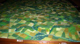
Gettysburg National Military Park is getting a new visitor center next year, and to make way for the new construction, the old center must be torn down. In the middle of the current center is a very popular exhibit called 'The Electric Map'. The map is the centerpiece of a small auditorium. The story of the battle is told with sequenced lights that appear to move around on the map. Some have said that the explanation of troop movements on the map explained the battle better than anything else. This exhibit has been around for a long time, and predates the Park Service at Gettysburg. The map was originally built sometime in the 1930s, and then went through a big overhaul in the 1960s. It had been operated privately until the National Park Service acquired everything in 1972. Up until the Park Service took over, the map was operated manually, but I've been told, that since 1972 it has been running on the same automated system. Gettysburg Ranger Eric Campbell told me that the exhibit is really loved by the public. "I'm sure the new exhibit will be great, but I'm sad to see this one go," he said.
The exhibit is so large, it is not at all easy to remove from the building. Because of the difficulty involved, there had even been talk about destroying the map along with the building. And while that may have been the last option, it stirred a lot of emotions in the Gettysburg community. In June, a citizen's group asked that the map not be destroyed, and park Superintendent John Latschar has agreed. The plan now is to cut the map into smaller pieces, apply shrink wrap, and put the pieces in storage somewhere in the park. There are no plans for the exhibit beyond that.
It is possible the map may not ever resurface, but at least this option leaves the door open for future alternatives, and doesn't destroy an exhibit that has been a visitor favorite for generations.


 Support Essential Coverage of Essential Places


Comments
Yes, this is rather sad to me. As a kid, the moving lights on the map made sense. It allowed me to visualize out on the battlefield what happened where. And other parks took notice of their popularity and effectiveness and made their own moving light displays -- Fort McHenry, Monocacy Battlefield, and others. I wish the Park Service would instead push to get rid of the McDonald's across the street. Chop it up, put it in shrink wrap, and save it for a future McDonald's museum! :-)
-- Jon Merryman
first it was the tower, now the map...SAD
I agree with Merryland.
At historical sites, it’s important to provide an understanding the event in historical context. Most of the Parks are very good at that.
Similarly, for a series of events at a historical site, it's important to provide an understanding of how and why those events unfolded. Who is where, what they knew, where they moved, and what happened as a result. I find 3D electrical maps extremely helpful in relating to the site. The electrical map at Gettysburg was one of those great aids.
In fact, at any of the large, sprawling Parks, a 3D map is always a focal point for visitors because it puts the Park in clear context.
I know the Gettysburg Visitor Center was in bad need of expansion/replacement. Will there be an equivalent in the new center?
The notion that the Park Service is doing away with this wonderful, informative map -- an indoor landmark in its own right -- makes me shake my head both in disbelief and in sadness. I don't think I could have made sense of "Killer Angels" had I not spent time lingering over that magical map. "Improvements" aren't always any improvement at all.
I've read this news with more than a slight twinge of regret; when I was a student at Gettysburg College, I found that the Electric Map was always a good first stop when family or friends visited and wanted to get a feel for the vast sprawl of the battlefield. I'm sure that the effect can be translated into this great digital age, but as the other folks have noted here, I will surely miss the old, technologically simpler presentation, and recall such effects as the little orange lights that were lit, as the lights in the auditorium dimmed, to simulate campfires behind the Union and Confederate lines at night . . .
And a quick side note . . . the historian Martin Duberman wrote a brief, one-act play about a fictional guy who was in charge of running the map, back in the 1970s, called "The Electric Map."
I saw the electric map on yesterday. I was sad to see on the internet that it would be going away. Having the map puts things into perspective and it gives some a view of what actually took place in Gettysburg.
It is never to late. Go to www.SaveTheElectricMap.com and take action. Email a friend.
I visited G'burg today and went in the new Visitors Center. There is *no equivalent* to the Electric Map there. It does a terrible job at providing a tactical perspective of the battle, something for which the Electric Map was perfect. The new Center is something like 20 times as big as the old one, yet they couldn't find room for the Electric Map? Unbelievable.