Piping plovers and sea turtles have halted traffic at Cape Hatteras National Seashore, lava flows and their gases have done the same at Hawaii Volcanoes National Park, and floods have shut down traffic at Olympic National Park and Mount Rainier National Park.
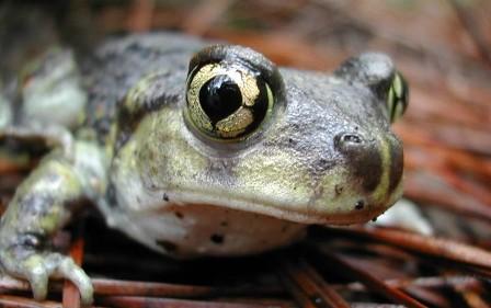
At Cape Cod National Seashore, a tiny toad has the power to divert traffic.
From late April through October the eastern spadefoot toad community that calls the landscape around the Province Lands Road in the seashore home tends to move about on rainy nights when the temperature rises to 48 and above. They go in search of breeding habitat in shallow ponds that form near the road, as well as to feed in the uplands. To help these toads, which are listed as "threatened" by the Commonwealth of Massachusetts, survive road crossings, seashore crews on occasion will detour traffic.
Now, while this species of toads is not rare in the Province Lands, this is one of their last strongholds in New England. Heavy mortality from vehicles, over the long term, could cause this population to decline.
To lessen vehicle impacts on the toads, the seashore officials will occasionally close Province Lands Road from just past (north of) the entrance to Herring Cove Beach to the intersection with Race Point Road. These closures will only occur at night, during or immediately after heavy rain, and will be infrequent.
Herring Cove Beach will remain accessible from Route 6 and Race Point Road will be unaffected, allowing continued access to Race Point Beach, Provincetown Airport, Point Ranger Station, and the over-sand corridor.
“The spadefoot toad migration is one of the many increasingly rare natural phenomena still to be found in the National Seashore," said Superintendent George Price. "We’re pleased that we’ve found a way to allow spadefoot toads to survive the trip to and from their breeding ponds, while still maintaining visitor access to Herring Cove and the Race Point area.”
The detours will be managed by signs and traffic control devices. Please drive slowly, to protect your own safety as well as park wildlife.


 Support Essential Coverage of Essential Places


Add comment