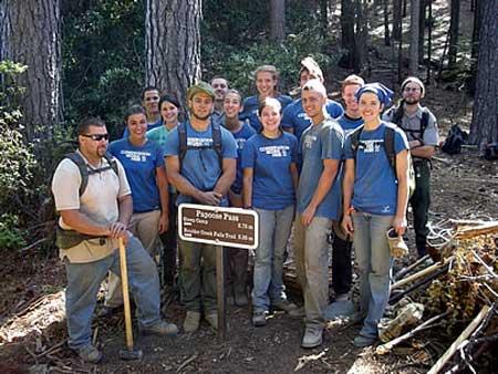
How many hours of hard work by volunteers and student interns does it take to build a trail? In the mountains of Whiskeytown National Recreation Area, the answer is: a lot. Visitors can now enjoy the result, following a ceremony which included the driving of a bronze spike to celebrate completion of the project.
Many people who are familiar with Whiskeytown National Recreation Area in northern California associate the site with water recreation, but the park has lots more to offer, including "cool rugged canyons, forests, streams and waterfalls."
A nice system of trails offers a variety of hikes in the park, and those opportunities have just gotten a lot better.
A ceremony was held earlier this month to mark completion of five miles of new trail through the heart of the park. The route connects the East side trails of Whiskeytown NRA with lands on the west side of the park, and was completed this summer by volunteer groups and Student Conservation Association (SCA) summer interns.
The trail passes over Papoose Gulch on the shoulder of Shasta Bally Mountain. You can download a park map and trail guides from this site. Check with the visitor center before you use the new trail, since it's too new to appear on the on-line map and guides.
Work on the project has been underway since the summer of 2007. A 16-person SCA crew of summer interns constructed over two miles of new trail through rugged Papoose Pass this summer.
SCA Western Regional Director Jay Watson and National Park Service Pacific West Deputy Regional Director George Turnbull were on hand to witness the placement of a bronze spike in a granite boulder, symbolizing the connection of the park's eastern trail system with its distant western trails.
Turnbull and Watson thanked the crowd of volunteers who assisted in the trail project and the SCAs who have contributed close to 10,000 hours of labor to this trail project over the past three years.
Park Superintendent Jim Milestone noted," Many citizens of Redding have volunteered their Saturday mornings over the past two years" to help make the finished trail a reality. Milestone recognized the Redding Mountain Bike Club, the Lemurian Bike Race and the Friends of Whiskeytown for significant contributions through grants or labor, and additional grants were provided by the Redding Foundation and McConnell Foundation.
Visitors didn't waste any time taking advantage of the new route: in conjunction with the ceremony, a ranger led some 25 hikers over Papoose Pass for a complete tour of the new trail section.
When the area's trail system is completed, will be possible to hike from the Sundial Bridge in Redding all the way to the Trinity Alps Wilderness Area.
The park website includes driving directions to the park and maps of the area.


 Support Essential Coverage of Essential Places


Comments
Let's not forget that many of the Whiskeytown trails are managed for shared use by hikers, bikers and equestrians. The Redding Mountain Bike Club was a key player in providing the resources to build Shasta-Trinity trail. Park Superintendent Jim Milestone recognized the Redding mountain bikers at the recent opening ceremonies and called their involvement "instrumental" in the park's volunteer efforts.
Thanks for pointing that out, Mark. Actually, we left that out intentionally to see if you were still reading the Traveler;-)
Is there a good map showing the trailheads in and out of the park ect.
Californiakayaker: For up to date information about new trails/segments and conditions, contact the park directly (phone 530-242-3400). To download a park map showing trails, visit this site. (There is also a HUGE (860 MB) pdf map of Whiskeytown at this site.) For Whiskeytown NRA trails information, visit this site and click on the trail you’re interested in. There is a comprehensive “All Trails Guide” at this site. Have fun.