It was President Reagan’s favorite joke and it goes like this.
A psychiatrist was observing two little boys in a room full of horse manure. The first one was very upset with all the dirt and filth. The second little boy clambered to the top of the pile, dropped to all fours, and began digging.
“What do you think you’re doing?” the psychiatrist asked.
The happy child replied, “With all this poop there must be a pony in here somewhere.”
And I felt exactly like the optimistic boy as Lenny and I scouted the hike on the Appalachian Trail we're going to lead at the Appalachian Trail Conservancy Biennial Conference Virginia Journeys. The area is famous for its feral ponies and I was happy to see the droppings.
This hike on the A.T. in southwest Virginia goes from Massey Gap in Grayson Highlands State Par to Elk Gardens (8.9 miles, 1,500 ft. of cumulative ascent). After placing a car at Elk Gardens, we drive to Massey Gap and try to find the A.T. We look at the map yet again and realize that we need to take the connecting Rhododendron Trail for a half-mile, and then pick up the A.T. southbound.
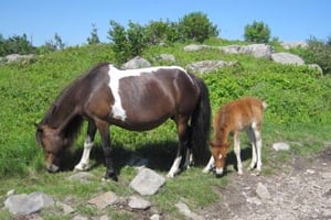
The trail crosses open meadows. Right now purple Catawba rhododendrons and flaming azaleas are in bloom. Mountain laurel will open up in a couple of weeks. Gold finches flit through the bushes. Hay has been left for the wild ponies. Soon the A.T. leaves Grayson Highlands and is back in Mt. Rogers Recreation Area. We come up two groups of ponies, including nursing foals.

Feral ponies graze along the Appalachian Trail. Photo by Danny Bernstein.
These ponies were introduced and now run wild. If the herd gets too large, the park sells them at an auction in September. Unfortunately, a careless and slow hiker has let his dog run ahead and disturb the ponies. In response, the ponies rear up their hind legs to kick the dog, but the dog runs away. The dog disturbs photographers more than the ponies. The trail climbs on rocky steps and goes through Fatman Squeeze Tunnel, a narrow passage way through rocks. Finally we reach Rhododendron Gap at 5,440 feet, and find a magnificent view. We're rewarded by a flat stretch, a boulevard of beech and spruce trees.
Bluets, tiny blue flowers, carpet the ground. It's a good area for camping, though there's no water on the ridge. Open meadows, "balds," are not natural; they were created by logging, grazing, and fire. Now the U.S. Forest Service keeps the land open by the same methods. Grazing wild ponies help as well.
Further down at Thomas Knob Shelter, we meet two guys on an overnight backpack. One is dreaming of doing the A.T. in a couple of years when he retires. "You can do it," I tell him. "One step at a time."
The trail enters the Lewis Fork Wilderness Area. All sorts of restrictions apply to a wilderness area, including that the group size can't be more than 10. The hiking gurus at the ATC conference have taken that into account. We'll lead a southbound group of hikers and two other volunteers will lead a northbound group.
Soon we get to the spur trail up to Mt. Rogers, the highest point in Virginia. There's no view at the top but it's a popular destination, nevertheless. A group of college students from College of Lake County in Northern Illinois are on a two-week trip studying physical education, biology and English. They congregate on top of the mountain to eat lunch, though several students still struggle to get to the peak. They tell me that they're hiking every day and have to journal and reflect on their hikes.
For English they also read A Walk in the Woods by Bill Bryson. The author didn't finish the A.T. and annoyed all of us that did, but it's a famous and funny book.
You won't find solitude on this section of the A.T., but it's a spectacular section even if you just go a mile out and a mile back. We keep meeting A.T. thru-hikers and other long-distance hikers, which is always a highlight for me. By the end of May, when we did this hike, the thru-hikers that we meet are at the tail end of the wave of Northbounders.
One retiree tells us that he knows that he's slow and that he'll have to flip-flop at some point. Hikers do a flip-flop when they think that they won't be able to make it to Katahdin in Maine before bad weather sets in. So they leave the trail, take a bus to Mt. Katahdin, and start walking south to where they've left off. It's a way to stretch out the hiking season. After the turn-off to Mt. Rogers, the trail goes into the woods and keeps descending. It comes out at Elk Garden, another beautiful open field.

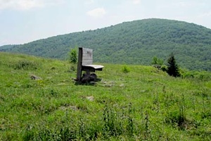
A bench for a rest awaits those who make it to Elk Garden. Danny Bernstein photo.
Here a hiking group had erected a bench at the top of the meadow in memory of one of their fellow hikers. Lenny and I sit for a couple of minutes and then continue down to VA 600 and our car. There are no elk in Elk Garden. As signs explain, elk were driven to extinction here as forests were logged and cleared for farming. Hunting also contributed to their demise. Rocky Mountain elk, a close relative to the extinct eastern elk, have been introduced in eastern Kentucky and some have made their way to southwest Virginia. The same elk species was brought back to Great Smoky Mountains National Park in 2001 and 2002.
As we drive back to Massey Gardens to pick up our first car, we see two cows coming up a trail and about to cross the road. They are frightened by the cars and scuttle down into the forest too quickly for me to take a picture.


 Support Essential Coverage of Essential Places


Comments
One of my favorite sections of my 2002 thru hike.
"Steamboat"