
Winter and spring are popular seasons for visiting Saguaro National Park, and for good reason. It's a great time of the year to enjoy the Arizona desert, and two "roads less traveled" and a variety of trails offer access to fine desert scenery.
Saguaro's two separate units straddle the city of Tucson to the east and west, and although there are similarities in the experiences and resources in both areas, there are some distinct differences as well. Not familiar with the park and want to sample its treasures? Here's a quick primer on scenic drives and hikes.
If your time to sample the park is limited'and that would be a shame'you'll need to pick one of the two units, since driving time alone between the pair can take about an hour, depending on your route and traffic. That said, if you must choose, I'd opt for the Tucson Mountain District (Saguaro West).
My impression from a recent visit is that the density of the signature saguaro cacti is higher in this unit; this district's Red Hills Visitor Center has better facilities for a fine interpretive program; and if you can allot the time, the nearby Arizona-Sonora Desert Museum offers an outstanding introduction to the plants, animals and ecology of the area.
If you want the combination of an easy walk and excellent close-up view of mature saguaros and other desert plants, the half-mile Desert Discovery Trail is located one mile northwest of the Red Hills Visitor Center on Kinney Road. This is also a great place for sunset photos that frame mature, multi-armed examples of the giant cacti.
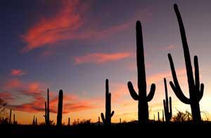
The Desert Discovery Trail is a fine spot for sunset views and photos as well an easy daytime stroll.
The unpaved Bajada Loop Drive in this unit of the park qualifies as a true park back road, but unless you're uneasy about getting off the blacktop, this is a fine trip, even in a passenger car.
Parts of the trip are one-way; others permit two-way traffic, so you can drive it as a continuous five-mile loop or just sample a short section. Pick up a map and a copy of the park's excellent newspaper, the Saguaro Sentinel, at the nearby visitor center before your drive.
Do be aware that the road can be dusty, and although it's a "good" dirt road, sections of it will rattle your teeth a bit if you try to crowd the speed limit. You came for the scenery, so just take your time and enjoy it!
There are plenty of hiking opportunities along this drive, but two short hikes are especially worthy of mention.
The Valley View Overlook Trail begins about 1.3 miles along the Bajada Loop Drive, covers just under a mile, and is rated by the park as "easy to moderate." It does require some slight up and down grades and negotiating a lot of stone waterbars and steps while crossing two washes (normally dry streambeds) , but it has some excellent scenery and views.
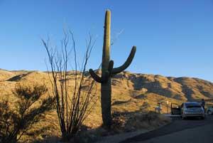
If you want to include a peek at ancient petroglyphs during a short hike, the Signal Hill Trail, at the 3.3 mile point on the Loop Drive, is a half-mile round trip, and is considered "easy," as long as you don't mind some steps and an easy grade.

The Signal Hill Trail includes views of ancient petroglyphs
A picnic area at the trailhead offers tables and shelters.
A second picnic area, the Ez-Kim-in-Zin, was featured last week in the Traveler as a candidate for the "most scenic picnic area in a park." It's accessed via the unpaved Golden Gate Road, which connects with and forms part of the Bajada Loop Drive. Again, a map is useful to avoid missing a turn. You can download one here that shows both the roads and key trails, and this brochure offers a fine summary of popular trails in the distict.
There are several main routes between the Tuscon Mountain District (Saquaro West) and town, but if you don't mind some extra twists and turns, take the Gates Pass Road either going or coming. Gates Pass Road is the western extension of Speedway Boulevard in Tucson, and the drive to the park offers some good scenery. You'll find driving directions to both units of the park at this link.
If you're staying on the east side of town and only have time for a visit to one section of the park, or if you want to keep your scenic drives on the pavement, by all means take a drive out to the Rincon Mountain District (Saguaro East).
That side of the park includes the Cactus Forest Scenic Loop Drive, an eight-mile paved route that provides access to a variety of trails. Parts of the drive are one-way and can be driven as a single loop, although some two-way sections offer quicker access for those headed specifically to a picnic area and several trailheads.
The drive is a winding one, so trailers longer than 35 feet or vehicles wider than 8 feet are not permitted. If you take the entire loop drive, don't despair if you don't see many large saguaros during the first couple of miles'the views will improve in the later half of the trip.
If you prefer to keep your scenic driving on the pavement, try the park's Rincon Mountain (East) District.
Those interested in an easy stroll and a quick introduction to desert plants will find both on the Desert Ecology Trail, a paved, one-quarter- mile loop adjacent to the road. Near the end of the drive, and not far from the Javelina Picnic Area, the Freeman Homestead Trail offers a 1-mile round trip, easy grades with some stone steps and signs suggesting activities for children. It offers some of the best close-up views in "Saguaro East "of the mature cacti that are the signature plant of the park.
The Rincon Mountain District also offers plenty of other trails for longer day hikes as well as trips into the high-country wilderness. A visitor center near the park entrance includes a slide show, exhibits and information. As is true of any desert terrain, you'll find the landscape'and your photos'a bit more interesting in the morning or late afternoon, when shadows accent the terrain and the light isn't as harsh.
Keep in mind, though, that the scenic drives in both units close daily at sunset, and even though you're not far from town, don't forget this is the desert, and common-sense safety guidelines should always prevail. Review these tips from the park staff before a hike or drive. You'll find more information to help plan a visit on the park website.


Comments
I lived in Tucson during 1986, and one of my favorite memories of that time is our midnight full-moon bike rides around Rincon's Loop Drive. But I agree with Jim that there are quite a few great hikes in both units, and this is a great time of year for them. Sadly, my time there was summer and fall, so hiking would've been an unpleasant option on most of those days!