When we're looking for information on virtually any subject, a key resource in today's world is the Internet. The challenge, of course, is figuring out where to find a specific item in the sometimes confusing cyber-tangle known as the "web." It's a bit like a radio commercial I heard years ago for an emporium in a small town in Texas: "We're the store of a thousand wonders; you wonder if we've got it, and we wonder where we put it."
That situation applies at times to the vast array of information available on the official National Park Service website, www.nps.gov, so here's a tip: tucked away on those pages are some items of potential value to anyone planning a park visit or for those who just love looking at maps.
"Find a National Park Service Map" offers free access to a variety of park maps, and you can search for them in several ways: use a drop-down of park names in alphabetical order, click on the state or U. S. territory in which the park is located, or use a drop-down list showing the parks found in each state or territory.
It's important to note that this site is not an effort to produce new maps specifically for on-line use, but rather an attempt to make years of NPS cartographic work more readily available to the public. Many of these maps and other images are the same versions you'll find in the printed version of park brochures.
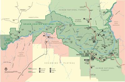
In addition to park-specific maps for the majority of sites in the NPS system and more detailed maps of specific areas within a park, such as this one of Yosemite Valley, you'll also find a variety of other maps, such as the "National Trails System Map and Guide" and the "National Park System Map - Four Color, No Relief," which is described as "a basic outline map of NPS System with dots representing parks."

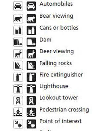
The site includes information about cartographic symbols and patterns used on NPS maps. Image from National Park Service.
Maps are fascinating documents for quite a few people, and "map geeks" will find lots to like on the site. Wondering about some of those symbols and patterns used on park maps? You'll find an explanation of standard cartographic symbols and patterns at this link. Amateur or professional cartographers will find a wealth of ideas and tutorials from both NPS and other sources at "Ideas and Techniques for Relief Maps."
General park fans will likely find items of interest at this "Gallery of National Park Bird's-eye Views," which includes a variety of images of specific features in NPS areas prepared by both NPS employees and contractors working for the agency. These images, such as the depiction of Garfield Peak in Crater Lake National Park, have been used in various NPS publications and exhibits at parks around the country.
Most of the maps on this site are available in both the Adobe Acrobat .pdf and Adobe Illustrator formats; an Adobe Photoshop version is also available for some documents. If you don't already have it installed, you'll need a copy of the free Adobe Reader software on your computer to view the .pdf publications.
It's also very important to note the size of the file listed for each map before you click that mouse; some of the files are quite large, so depending upon the speed of your internet connection, you may need to be patient. One tip: unless you have a very fast connection, don't try to multitask and download more than one of these maps at a time. Tips for printing oversized maps on standard computer printers are available on the site.
Responding to the shift to portable digital formats, the NPS is beginning to offer some map-related apps for both Apple iPads and smartphones. Those apps are not part of the "Find a National Park Service Map" site, but you'll find one example of such apps from Boston National Historical Park here. That free app allows visitors to "listen to ranger talks, follow guided tours, pinpoint their location on a map, and get live updates about park events," and it's available by searching for "NPS Boston" on the Apple App Store or Google Marketplace.
"Find a National Park Service Map" pulls together in one location maps and cartographic information previously created by the Harper's Ferry Center (HFC) which is the home of the "media specialists" for the NPS. It's a potentially useful site for researching information about a park or for planning a trip, although you'll almost certainly need a full-size printed version for practical usability away from your computer.
The site will be especially appealing to those who simply enjoy maps and the opportunity for a vicarious visit to special places around the country. Unfortunately, there were a few broken links when I tested the site recently, such as those for the "American Revolution at a Glance" maps.
Such on-line glitches aren't limited to this site, and they are an example of the pros and cons of providing information on the Internet. Creating and maintaining any on-line presence requires staff and money, both of which are in short supply at times'both in and out of government.


 Support Essential Coverage of Essential Places


Comments
I must be a map geek. I use Find a Park regularly when I am searching an area by state to see what Parks are near by that I might visit. I enjoyed the link to the Bird's eye View in this article...very nice.