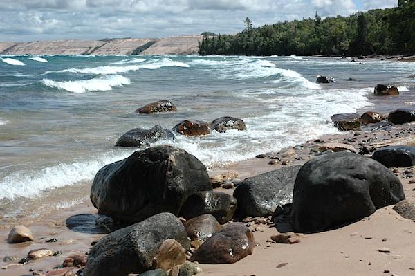
Twelvemile Beach at Au Sable Point with Grand Sable Dunes in the distance/NPS, Greg Bruff
Pictured Rocks National Lakeshore, where Lake Superior's stupendous power pounds Michigan's craggy shore, is a tremendous place to kayak. But plan for a few extra days unless you have a really favorable weather report.
Pictured Rocks runs along 40 miles of shoreline northeast of Munising. Cliffs of Cambrian sandstone rise from the lake's clear, cold waters -- some more than 200 feet above lake level. There are rocks on one side and one-hundred miles of open lake on the other. That makes for some dicey paddling when the wind whips out of the north or northwest, but, thankfully, there's plenty to do in the meantime. My trip to the park illustrates the point.
Our first day, my wife, Susan, and I paddled from Munising out to Grand Island National Recreation Area. While it's not part of the national park, it's still a terrific place to paddle, dawdle in sea caves, and camp on the beach.
The second day, aware of impending rough weather, we struck camp and beat a hasty bearing to the cliffs of Pictured Rocks. We intercepted the shore near Miner's Castle, an imposing headland, and followed the cliffs to the northeast. These tall, massive cliffs, pock-marked by indentations and rock pillars, are interrupted by pocket beaches. A nifty hole in a cliff spouted water as waves slapped its face.
These cliffs are named for the deposits of minerals that leach from the cliffs to stain their lake-ward face. The sandstone is predominantly a rich buckskin color, with vertical traces of bright orange, lurid purple, rust brown, and even indigo and turquoise.
Bobbing on the building waves, we weaved and sloshed drunkenly through the massive sea arch at the point known as Lover's Leap. (Longago tourists or local boosters dusted off their best Victorian cliches, hence Lover's Leap, Indian Head, and Bridal Veil Falls.) We continued to Grand Portal Point, a foreboding, for boating, knuckle of sandstone pointing north toward Ontario.
Well, enough fun for the day. Rather than hang out fully exposed to the open lake, we retraced our way back toward Munising.
The next morning, six-foot waves filled the lake all the way to Canada, beating the base of the cliffs mercilessly. There'd be no paddling on the big lake that day -- or the next, as it turned out. But we found other things to do. Some 90 miles of trail wind through 73,000 acres at Pictured Rocks. Much of the mileage follows the high cliffs above the lakes. We hiked to the precipice of Spray Falls, where Spray Creek launches into thin air in a free fall to the lake, and we walked White Pine Trail beneath mammoth beeches and hemlock. We were barely able to clasp our arms around a hemlock -- at least 10 feet around.
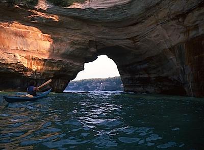
Exploring Pictured Rocks National Lakeshore by kayak can involve negotiating arches Lake Superior has carved into the landscape/Greg Breining
Susan left for home, and the next day, when the wind finally abated, I left my camp on Little Beaver Lake and paddled along a short channel into Beaver Lake and then down sandy, crystal-clear Beaver Creek. After portaging a massive logjam, I reentered the stream and bobbed onto Lake Superior.
The cliffs were behind me as I paddled east, but more than half of Pictured Rocks' shoreline still lay ahead of me. I made an astonishing discovery: the namesake cliffs were only part of the attraction. I paddled along the endless sand of Twelvemile Beach, which was even more enjoyable. Through late morning and early afternoon, I paddled, stopped, and lounged whenever I wanted.
The Grand Sable Dunes became visible as I rounded the point, revealing the white cylinder of Au Sable Light. Huge sand hills sloped up more than 200 feet from the water to form a big slanted beach.
I vowed that next time I came to Pictured Rocks, I'd take a quick look at the rocks and spend the rest of my time at the beach, perfect for its beauty and solitude.
If you go:
The best time to paddle Pictured Rocks is during July and August, when water is at its warmest and weather most likely to be calm. Winds rise in September, but you'll have more privacy. Except on the warmest, calmest days, you'll want to wear a life vest and a wetsuit or drysuit. Keep an eye out for the tour boats that bring tourists to see the cliffs.
If you don't have gear or experience, go with an outfitter. Paddling Michigan/Uncle Ducky Outfitters, 1331 West M28, Munising, MI 49862. 877-228-5447.
For trip information, check Pictured Rocks National Lakeshore, P.O. Box 40, Munising, MI 49862-0040. 906-387-3700. A backcountry permit is required to stay overnight in Pictured Rocks. Permits must be obtained in person and not more than one day before your departure. For access points and lakeshore campsites suitable for kayaking, see Backcountry Trip Planner.


Add comment