
The Lewis Channel Trail offers a great afternoon's hike/Kurt Repanshek
Late September and early October, they say, are the best times to while your day away hoping to hook into one of the brown trout that call Shoshone Lake in Yellowstone National Park home. And one of the best ways to reach the lake for some fishing is via the Lewis Channel Trail.
You can reach the lake by canoe or kayak, but that requires paddling the length of Lewis Lake and then paddling and pulling your boat up the Lewis River Channel. It's so much easier, quicker, and dryer to park your rig at the trailhead for both the Lewis Channel Trail and the Dogshead Trail and walk to the top of the channel. Whether you take the Lewis Channel Trail or the Dogshead Trail depends on how much time you have, or how anxious you are to wet your fly. The Lewis Channel Trail runs 7 miles from trailhead to Shoshone Lake, while the Dogshead Trail, which leaves from the same trailhead, takes a more direct route and arrives on the lakeshore in about 4.5 miles.
On a cold, drizzly late August day we decided to opt for the Lewis Channel Trail, as we wanted to exercise our legs a bit more than the Dogshead Trail would allow. Of course, the fact that the Lewis Channel Trail skirts the length of the channel factored in, too, as we were planning to revisit it via canoe.
From the trailhead on the left side of the road not too far north of the Lewis Lake Campground we headed west through the relatively flat lodgepole pine forest. It wasn't long before we passed a lily-pad cloaked pool just north of the lake, and then found ourselves at the channel. From there the trail swings about 90 degrees to the right and parallels the channel all the way to Shoshone Lake. Much of the trail passes through mature forest, though there are some areas where past burns have given way to "doghair" stands of pines, a name drawn from the extremely dense plantings that evolve from the way lodgepole pine cones dispense their seeds after fires melt their sticky casings.
As the trail runs north towards Shoshone Lake, it provides sweeping overlooks of the Lewis River Channel (and any boat traffic). With cooler fall weather here, and better fishing prospects, either one of these trails are great options for a day in the park. You can, of course, combine the two for a loop hike of roughly 11 miles.
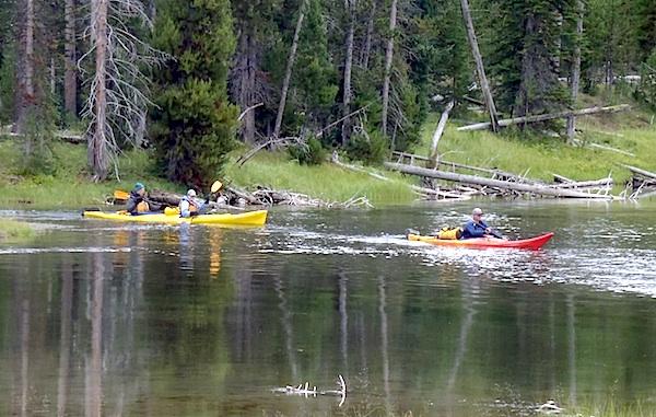
Navigating the Lewis River Channel is a must if you want to paddle Shoshone Lake/Kurt Repanshek


Comments
Wrong thread
Kurt--following the earthquake that struck Yellowstone in 1959, I hiked into Shoshone Lake via the Dogshead Trail to visit a fellow ranger who was stationed at Shoshone. While there in his little cabin, we felt a rumbling and thought it was another aftershock. Much to our surprise, it was an eruption of Twin Geyser. (I am almost sure I have that name right but a Google check showed there was a Twin Geyser in the West Thumb Geyser Basin. Since I was stationed at the West Thumb Ranger Station--pre Grant Village--I may have the name confused. I will do further checking.) Later investigations indicated that we were only the 6th and 7th reported observers of this geyser erupting. I have no idea whether it has ever erupted agaIn, but if so, I hope someone was there to observe it. The water came from two cones and about 15 feet in the air, the columns joined. It was one of many memorable experiences in Yellowstone.
Rick
Sorry, the correct name is Union Geyser.
Rick