
Editor's note: Last fall, Colleen Miniuk-Sperry took her paddleboard to Lake Powell, in Glen Canyon National Recreation Area, one of the many units of the National Park System where SUPing is allowed, to explore the NRA for three days with her mother providing support in a kayak.
“If everyone knew just how beautiful it is, everyone would be out here,” my 64-year-old mother, Jacque, declared as she gently and gracefully stroked the muddy Colorado River with her kayak paddle. “Just think, we’ll get to see amazing sights only a few people have—or ever will—see on this adventure,” I responded with a smile from my 14-foot inflatable Stand Up Paddleboard.
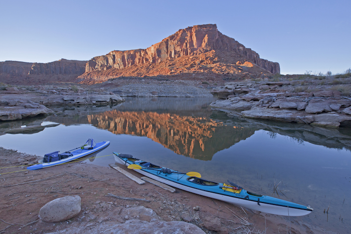
Merely one hour before, we left my father, my best friend, cell phone service, and daily to-do lists on the rocky shores of the remote Dirty Devil River launch area (along Highway 95 in Utah) at the northernmost end of Lake Powell. In the four days ahead, we intended to paddle approximately 47 miles of Lake Powell’s main artery—from Hite to Halls Crossing— pulsing through the vast 1.25 million acres comprising the Glen Canyon National Recreation Area in Utah.
Although controversy has surrounded North America’s second-largest manmade reservoir since the completion of the Glen Canyon Dam in 1963 (which impeded the Colorado River’s flow), we wanted to experience this pristine landscape not how it was, not how it will be, but rather just how Glen Canyon appears today. After all, the sinuous canyons, undulating waves, and croaking coots do not hold any political views. We saw no reason why we needed to possess them either while we paddled in their picturesque home.

Jacque Miniuk kayaks past striated sandstone cliffs called The Palisades on the Colorado River/Lake Powell in Glen Canyon National Recreation Area, Utah/Colleen Miniuk-Sperry
Turbid waves tickled ochre-colored, 600-foot-tall sandstone cliffs as a squawking great blue heron soaring beneath a clear blue November sky welcomed us into the wild—and into the canyon’s embrace. Thanks to the combination of Lake Powell’s lower water level (around 3,605 feet elevation vs. full pool elevation of 3,700 feet) and the high incoming Colorado and Dirty Devil rivers’ flow (about 107 percent above average), a fast-moving current pushed us effortlessly past the deserted Hite marina and a staggering narrow corridor of rugged bluffs called The Palisades. My DeLorme InReach clocked our speed at an impressive 5.7 miles per hour!
As we passed the mouth of White Canyon, an oddity appeared in the water in front of my board and spanned my entire peripheral vision. Using my paddle as a brake, I stopped on the definitive line where the opaque brown silty flow of the Colorado River conceded its inevitable fate and melted into the crystal-clear jade-green waters of Lake Powell. I quickly dipped my left foot into the chocolate milk beneath my board as if to thank the river for carrying us this far. Then, I dropped my right foot into the verdurous water to introduce myself to the lake.
“Ma, you have to see this!” I exclaimed, pointing to the phenomenon with my paddle. “The river! It gives up right here!”
Without the benefit of the river’s current—and with the addition of a southwesterly breeze—our progress slowed, but our unhurried pace allowed us to connect more deeply with our ever-changing surroundings. We contemplated the intense ruckus caused after house-sized boulders tumbled off the cliffs and came to rest on the shore below ages ago. We observed two bald eagles resting on a thin cliff ledge. When air bubbles rose to the water’s surface, we wondered if historic relics were gasping for air from the bottom of the drowned canyon. Filled with gratifying wonder and amazement, we pulled onto a sandy spit in Fourmile Canyon to camp as the day’s sun dropped behind serrated spires.
20% off Yakima Roof Racks and Accessories on Closeout. Shop Now at nrs.com!

A nearly full moon took its place, illuminating the tips of monolithic buttes until thin cirrus clouds dimmed the light in the still of the night. The evening’s weather forecasts suggested a cold front (with high winds expected to top out around 30 mph) would arrive the following afternoon.
We woke a few ticks after 6 a.m. to threatening clouds hovering in the east. When we re-entered the main channel, we met a nonchalant breeze. However, as soon as we turned west, it abruptly transformed into an onslaught of unrelenting crosswinds. We looked like happy dogs sticking our heads out of a fast-moving car window. I pointed toward a distant peak called The Horn and shouted over the wind’s howls to Jacque, “GO TOWARDS THAT POINT. I’LL MEET YOU THERE!”
She nodded and then propelled herself to the southern shoreline, bobbing across two-foot whitecaps. To gain more control over my board’s direction, I sat down on my SUP’s “loveseat” and tugged my paddle through what felt like wet cement.
After rounding The Horn, a fierce headwind roared against the sheer sandstone walls and brought both our vessels to a halt despite rowing with all our strength. Tumbleweed bounced off the shore and skipped across the water’s surface. Spray drifted in the air, spinning ghostly apparitions.

The full moon illuminates the sandstone cliffs near Cedar Canyon (mile 113) under a sky full of stars. Viewed from our Day 3 camp on Lake Powell in Glen Canyon NRA/Colleen Miniuk-Sperry
We took spontaneous refuge on a 300-foot-diameter island covered in cobble, driftwood, and tumbleweed at the western tip of The Horn. As we waited for the feisty squall to pass, we became “Thing-Finders” like my favorite childhood book character, Pippi Longstocking. We found a wheel-shaped slice of petrified wood, studied bizarre driftwood patterns, and marveled at different colored rocks. Intensifying winds and a hesitant drizzle—paired with a million-dollar view of striated stone monuments around us—made our decision to sleep overnight on what we affectionately called “Gilligan’s Island” a simple one.
A calm breeze gently flapping against our tent’s rain fly brought us out of our morning slumber. We hastily downed breakfast, packed our gear, and launched to take advantage of the more favorable conditions. After paddling about two miles into a light headwind, we reached Red Canyon’s bay. The winds suddenly ceased, and the water turned to glass. We entered a euphoric dream.
I looked towards Blue Notch Canyon to see light, shadow, and a palette of pastel colors dancing an elegant tango from mesa to mesa, bluff to bluff, as if the late famed Western painter Thomas Moran was brushing the scene to life right before our eyes. The sun peeked out from clearing clouds, spotlighting individual alcoves and arches hidden among the jigsaw-puzzle patterns on stoic rock faces. Mesmerizing ribbons of waves streamed from the bow of my board, which was the only way I knew I was still moving.
“It’s like paddling through silk,” Jacque whispered above nature’s silent song.

Jacque Miniuk paddles out of Good Hope Bay on Lake Powell in the Glen Canyon National Recreation Area, Utah/Colleen Miniuk-Sperry
Before noon we glided into Good Hope Bay, where we waved to the only four boats we encountered all trip. Although we had reached our intended stopping point for the day, we agreed the sublime conditions were too delicious to stop. We continued winding six additional scenic miles until we found a small beach near the mouth of Cedar Canyon to call home for the night. With stars erupting onto a black velvet sky, we celebrated our glorious 15-mile triumph—and Thanksgiving Day– by mowing down freeze-dried dinners and toasting a glass of wine.
As we concluded our adventure at Halls Crossing the following day, I contracted a severe case of “canyonitus,” a term folk-singer, writer, and Glen Canyon explorer Katie Lee used in her book, All My Rivers are Gone, to describe the infallible allure of this magical place. Hungry for more, I began planning a future trip to paddle the entire 147-mile length of Lake Powell.


Comments
beautifully written! Bravo