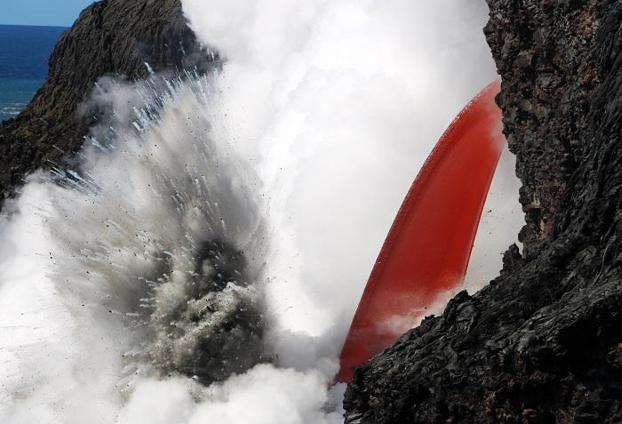
An open lava stream poured out of the lava tube, perched high on the sea cliff, and into the ocean on January 28 at Hawai'i Volcanoes National Park/USGS
The spectacular lava “firehose” that formed after a lava delta crashed into the ocean at Hawai‘i Volcanoes National Park on New Year’s Eve disappeared on Thursday when another chunk of newly created land broke off into the sea.
Although no one was injured, geologists from the Hawaiian Volcano Observatory arrived to the Kamokuna ocean entry site just minutes before the sea cliff collapsed without warning at about 12:55 p.m. Thursday, “generating a noticeable, but not unusually large, wave propagating outward from the rockfall location.” Another collapse occurred at 4 p.m. On Saturday, the HVO said the dimensions of the collapsed block had not been documented, but it was “significantly larger” than a 98-by-16-foot portion of block that remained.
The “firehose” was no longer visible, but lava spatter and black sand flying through the steam plume indicated that lava was still flowing into the ocean and interacting explosively with seawater. Just below the left side of the steam cloud, a small shelf of the Kamokuna lava delta that survived the 26-acre New Year's Eve collapse could be seen.

A small block of rock (left) remained at the eastern end of the crack after a collapse on February 2/USGS
The U.S. Geological Survey scientists had hiked to the area to assess a crack running parallel to the sea cliff about 16 to 33 feet behind the stream of lava that first showed up in a thermal image taken January 25. The geologists determined that the temperature within the eastern end of the crack was about 428 degrees Fahrenheit. Ground inspection on January 28 found the crack to be about 1 foot wide, but four days later, it had widened to a gap of about 2.5 feet.
In between, the HVO noted that “the interaction of molten lava flowing into cool seawater caused pulsating littoral explosions that threw spatter (fragments of molten lava) high into the air. Some of these incandescent clasts fell on top of the sea cliff behind the ocean entry, forming a small spatter cone. During one exceptionally large burst, spatter was thrown about twice the height of the sea cliff.”
This portion of the sea cliff was deemed “highly unstable,” and prompted Hawai‘i Volcanoes to move its viewing area on January 30 for safety reasons.
“The seaward block bounded by this crack was visibly moving up to 1 cm (about 1/2 inch), possibly in response to explosions below the ocean entry as hot lava mixed with cool ocean water,” the HVO wrote. “In addition, ground shaking could be felt up to several hundred meters (yards) away.”

This thermal image from January 25 shows two plumes of scalding hot water branch out from the entry point. The lava stream itself is the very hot feature right of center. Just above the lava stream is a narrow line of high temperatures that shows the crack/USGS
While the “lavafall” is gone, the “61g” flow is still entering the ocean and creating a large plume of steam. People can hike to the new viewpoint, though visitors are encouraged to check the current conditions.
“As a strong caution to visitors viewing the ocean entry (where lava meets the sea), there are additional significant hazards besides walking on uneven surfaces and around unstable, extremely steep sea cliffs,” Hawai‘i Volcanoes posted Friday. “Venturing too close to an ocean entry on land or the ocean exposes you to flying debris created by the explosive interaction between lava and water. Also, the new land created is unstable because it is built on unconsolidated lava fragments and sand. This loose material can easily be eroded away by surf, causing the new land to become unsupported and slide into the sea.”
For hiking tips, visit the park website. For County of Hawai‘i lava viewing information, call 808-430-1966. For the latest eruption updates, visit the USGS Hawaiian Volcano Observatory website. Monitor air quality at www.hawaiiso2network.com.
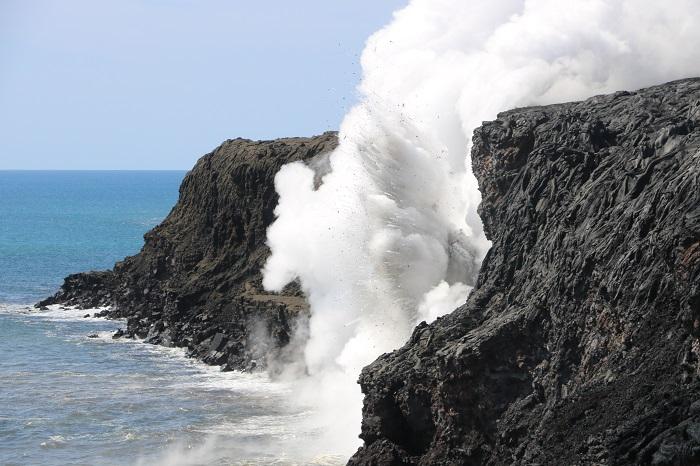
Spatter and black sand flying through the steam plume indicate that lava was still flowing into the ocean and interacting explosively with seawater/USGS


Add comment