
Editor's note: The following is advertiser-supported content from Traveler's Essential Park Guide, Summer 2017
Just like John Muir, be sure your vacation sets aside some time to tramp around the spectacular mountains of Yosemite National Park and enjoy this incredible scenery. Just steps from your car, you’ll leave the crowds, traffic, and bustle behind and enter a wilderness unlike any other. Granite domes soar above you, waterfalls thunder next to you, birds’ shrill calls fill the otherwise still forests. Take a casual stroll around the Yosemite Valley, or break a sweat and head up, up, up into the canyons. Or head to the high country for an easier romp in the high alpine meadows and towering peaks above timberline.
While some hikes require a permit because of their popularity, most are open and ready for your best hiking shoes. Make sure you take some water, a map, a raincoat, and a snack; you’ll probably need all four. Keep an eye on the skies for gathering storms and lightning, and stay away from the high peaks.
For a base camp during a multiday stay in the park, Yosemite’s Scenic Wonders Vacation Rentals offers more than 100 vacation properties at Yosemite, Wawona, and the Oakhurst/Bass Lake area. They make a perfect place to clean up after your day on the trail, relax into the evening, and rest up for your next day’s hike.
Here’s a short list of some memorable Yosemite hikes, in and out of the valley:
Yosemite Valley
You can hike the full loop (11.5 miles round trip) or the half loop (7.2 miles round trip) and experience the Yosemite wilderness on a fairly easy trail. You’ll pass through verdant meadows and along the base of towering granite cliffs as the Merced River flows peacefully nearby. You can pick up this trail in a number of areas, including Lower Yosemite Falls or Yosemite Village.
This easy hike takes you to Mirror Lake and Tenaya Creek, right at the base of Half Dome. It’s only a 2-mile round trip, with just 100 feet in elevation gain. It’s a great way to get away for a brisk stroll. The trail begins at shuttle stop #17.
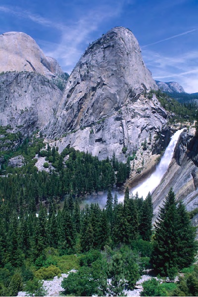
This daylong trek has to be on your bucket list. It’s a strenuous 16-mile round-trip hike, with a 4,800-foot elevation gain, but it’s worth every step. Like a sentinel, Half Dome oversees the valley, and the view from the top of Clouds Rest, Glacier Point, and Yosemite Valley is nothing short of stupendous. It’s 2.7 miles to the top of Nevada Falls (the Mist Trail is a great, cooling hike all by itself), and another 4.4 miles to the summit. You’ll need to concentrate at the top though, as the final 400 feet is a heart-pounding climb (with handholds and cables) up very steep, very slick, granite. Save some energy for the trip down, and don’t go anywhere near the top when thunderstorms threaten. There is a permit required, so plan ahead.

Along the Tioga Road you’ll find plenty of granite domes studded with trees to ramble on/Kurt Repanshek
Though nearly 150 years old, this trail is a popular, and strenuous, hike to the top of North America’s tallest waterfall, at 2,425 feet. And this spring and summer, with the deep winter snows melting, it will be roaring. You’ll gain 2,700 feet as you wind your way up a number of switchbacks to reach Columbia Rock at a mile, and can end your upward hike there. Or, head another 2.6 miles up to the top of the falls. Overall, it’s a 7.2-mile jaunt, with another mile if you venture out to Yosemite Point. Since this trail faces south, take plenty of water on those hot summer days. For a quick peek of the falls, take the easy, mile-long trail to the base of the falls and feel the spray in your face.
Tuolumne Meadows
Cathedral Lakes Trail
Take this 7-mile round-trip hike and see one of the most picturesque, and peaceful, scenes in Yosemite, as the 10,940-foot Cathedral Peak reflects into these backcountry lakes. You’ll see glacially scoured granite, mountain streams, and wildflower-filled meadows. This popular hike begins a half-mile west of the Tuolumne Meadows Visitor Center
Lyell Canyon via the John Muir Trail
The John Muir Trail ties together Yosemite and Sequoia national parks. Commit to the full two or three weeks to hike the entire 211-mile trail, or spend an afternoon from Tuolumne Meadows to Lyell Canyon. Hike south from the Backcountry Wilderness Center a short distance to the Lyell Fork of the Tuolumne River. You can soak your feet in this peaceful stream, and watch trout lurking in the pools. You’ll cross the creek on two bridges, with views of Mammoth and Cathedral peaks. Walk out as far as you wish, but save some energy, and daylight, for the return.

Yosemite’s high country offers countless miles of hikes, some of which lead to Dana Peak/Patrick Cone
Dana Peak Summit Trail
Dana Peak, at 13,061, is the second-highest peak in the park, and a moderately strenuous 5-mile hike with rewarding views. There are no trail markers, but you will walk through the meadows and then hit a series of switchbacks. The final summit is a scramble in the boulders, but once on top it’s a 360-degree panorama, with saline Mono Lake and the vast Sierra all around.
Glacier Point
McGurk Meadow, Bridalveil Creek, and Dewey Point
Start at the McGurk Meadow trailhead, and head a mile down to McGurk Meadow and a historic cabin. Another mile and you’ll have a choice between the trail west to Dewey Point (8.2 miles round trip) or east to Bridalveil Creek (4 miles round trip). The wildflowers are great along these trails.
Sentinel Dome and Taft Point
This moderate, 2.2-mile round trip hike begins at the Sentinel Dome/Taft Point trailhead (6 miles east of Bridalveil Creek Campground turnoff). You can head to the left toward Taft Point, but watch your step at The Fissures; it’s a long way down to the Yosemite Valley. Or you can turn right at the trailhead and hike toward Sentinel Dome and scramble to its top for a panoramic view.
Ostrander Lake
At the Ostrander Lake trailhead (1.3 miles east of Bridalveil Creek Campground turnoff), this strenuous, daylong hike takes you deep into the Yosemite wilderness. It’s an 11.4-mile round trip, with a steep 1,500-foot elevation gain, which will give you views of Mount Starr King, the Clark Range, and Half Dome. Take your lunch at the pristine Ostrander Lake before heading back.

Take the Lyell Fork of Tuolumne River along the John Muir Trail and you can wander all the way to Sequoia National Park/Kurt Repanshek


Add comment