
Despite its sublime appearance, there's a lot of shaking going on inside Mount Rainier/Rebecca Latson
Yellowstone National Park isn't the only park in the system that experiences swarms of earthquakes. According to the U.S. Geological Service's Volcanoes staff, more than 20 earthquakes have been recorded at Mount Rainier National Park in the past week or so.
For comparison's sake, a normal week generates maybe two recorded quakes at Rainier, according to the USGS.
These swarms are a common and expectable occurrence at active volcanoes such as Mount Rainier. While interesting, most never result in surface changes. These earthquakes are inferred by scientists to be caused by processes occurring in Mount Rainer’s hydrothermal system. The hydrothermal system is the region beneath the volcano containing hot mineral-rich water; one manifestation of this system is the boiling-point fumaroles that are found at the volcano’s summit. Similar to pipes in geothermal plants, cracks transporting water away from a hot source may seal shut as the water cools and loses its dissolved minerals. Earthquakes are created when sufficient fluid pressure builds behind these seals to fracture them.
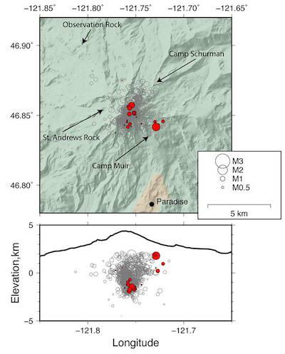
Map view of well recorded historical seismicity at Mount Rainier since 2007 (gray circles) with seismicity since September 11 plotted as filled red circles. Location of seismic stations indicated by arrows. Bottom: Cross-sectional view looking north shows earthquake depths. Black outline is a west-east elevation profile of Mount Rainier. Circles are sized with respect to earthquake magnitude. Data are from the Pacific Northwest Seismic Network/USGS graphic by Wes Thelen
For the current swarm, earthquake location, depth, and size are all consistent with background seismicity; the only thing that is different is the event rate.
The seismicity uptick started late September 11 with a swarm of five earthquakes located 1-2 km (roughly 0.5-1.5 mi) to the southeast of the summit area. These earthquakes were shallow (up to 2 km above sea level), small (maximum magnitude was a M1.6), and in an area that has not had a lot of previously recorded seismicity. Beginning September 13, earthquakes were also detected about 1 km to the northeast and southeast of the summit, in areas where earthquakes typically occur at Mount Rainier. Depths for these events were 1-2 km below sea level, which is also typical for background seismicity at the volcano, and event magnitudes were small (maximum magnitude 1.2)
In total there have been 23 earthquakes since September 11, with event rates of up to eight located earthquakes per day. Although this is higher than the normal seismicity rates at Mount Rainier, it is not unprecedented. Over the past 10 years there have been three previous periods with similar or higher event rates (September 2009, April 2015 and May 2016). Current event rates are similar to those seen in April 2015 and May 2016, but are far smaller in rate, energy release, and total number of earthquakes than what was seen in September 2009, when a swarm featuring hundreds of located earthquakes occurred over a three-day period.
The most likely scenario for the current swarm is that elevated earthquake rates will continue for days to a few weeks before slowly decaying to background rates of seismicity. Each swarm provides seismologists with more perspective on the personality of the volcano and aids in our ability to assess hazards in the future. As always, scientists at the USGS‒Cascades Volcano Observatory and Pacific Northwest Seismic Network will continue to monitor the situation and provide updates as conditions warrant.


Add comment