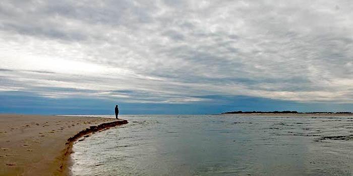
Hurricane Sandy in 2012 ripped a new channel in the Otis Pike Wilderness at Fire Island National Seashore that funneled waters from the Atlantic Ocean into the Great South Bay. A new report projects greater sea level rise and storm surges will impact the park system/NPS
A report that evaluates how sea level rise and storm surges could impact coastal units of the National Park System points to some significant threats, but stops short of suggesting protective solutions and seemingly is being held at arm's length by the National Park Service.
The report, which acknowledges that it's just the first step "in assessing how changes in sea level and storm surge may affect national park units," says parks in the Northeast, National Capital, and Southeast regions of the National Park System will face the highest rise in sea level by 2100, in large part due to "anthropogenic climate change."
"Recent analyses reveal that the rate of sea level rise in the last century was greater than during any preceding century in at least 2,800 years," the authors note in the study's introduction. "Human activities continue to release carbon dioxide (CO2) into the atmosphere, causing the Earth’s atmosphere to warm. Further warming of the atmosphere will cause sea levels to continue to rise, which will affect how we protect and manage our national parks."
The Importance of Understanding Contemporary Sea Level Change for Parks
From rocky headlands to gentle beaches, some of the most splendid and beautiful places in the United States are national parks on our ocean shorelines. Over one quarter of all national park units are coastal parks, home to nesting shorebirds and sea turtles, historical forts and lighthouses, and opportunities for recreation and respite. Many are living witness to our national story – true icons of our history (Photo 3). But despite their great diversity, importance, and ability to provide windows to the past, changes in sea level affect them all.
Today’s managers of these parks face new challenges—challenges unimagined by builders of the forts and lighthouses within them, challenges unprecedented for the species that inhabit them, and challenges unanticipated by those who secured these places as part of the National Park System. Knowledge of sea level projections must now augment managerial skills in park administration, resource protection and conservation, interpretation, and community and civic engagement. To support managers of coastal park units, this report provides projections for sea level change and storm surge under several scenarios. As a reference for staff, it also summarizes scientific understanding of the basis for these changes, and sources from which scientists develop sea level rise projections.-- Sea Level Rise and Storm Surge Projections for the National Park Service
The report also notes that "single storms cannot be wholly attributed to anthropogenic climate change," but adds that climate change is leading to greater storm surges. Hurricane Sandy, which roared up the East Coast back in 2012, did great damage with its storm surge. The cost to repair damage in the park system surpassed $370 million, the report pointed out.
"When this change in storm intensity (and therefore, storm surge) is combined with sea level rise, we expect to see increased coastal flooding, the permanent loss of land across much of the United States coastline, and in some locations, a much shorter return interval of flooding," the authors wrote.
The National Park Service, which offically stopped short of embracing the report by inserting language stating that, " Views, statements, findings, conclusions, recommendations, and data in this report do not necessarily reflect views and policies of the National Park Service," did not immediately respond when asked how the agency would respond to the findings in the document.
At Florida State University, Dr. Tisha Holmes said there's a need to come up with defenses to sea level rise and storm surges.
“This question of how do we project what is going to happen over the long term, in the face of uncertainty, is a really hard question that a lot of different sectors of society are struggling with," said Dr. Holmes, whose area of interest is climate change and adaptation along coastal zones. "So we see these types of projections being used with planning for infrastructure upgrades, like how high do we need to raise our levees, or what types of storm surge, what type of sea level rise, are we going to see in the future, and then how do we construct things that are resilient to that.
“But the question for parks, is really interesting, because they’re not only ecological places that need to be preserved, but also socio-cultural infrastructure that is going to be impacted," she added during a phone call. "So I think having a nationwide assessment of what places are going to be impacted is very critical and really important, and it’s good that the Park Service is doing that."

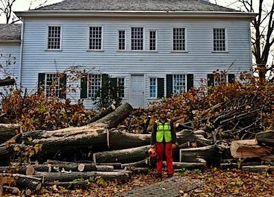
More potent storms not only will intensify tidal surges, but could pack stronger winds such as those from Hurricane Sandy that downed scores of trees at Morristown National Historical Park in New Jersey/NPS
The question now, the professor said, is how will the Park Service react to these projections? What adaptive options will the agency consider, and at what cost?
According to the report, "the shoreline within the National Capital Region is projected to experience the highest sea level rise by 2100," a rise of more than 2.5 feet. The highest rise by 2100, of 2.7 feet, is predicted to be along the shoreline near Wright Brothers National Memorial in North Carolina, it added.
Looking at projections for 2030 and 2050 and out to 2100, the authors noted that "the Northeast Region almost tied with the National Capital Region in 2030 based on average projected sea level rise, with the National Capital Region ranked highest. The Alaska Region ranks lowest for all three time intervals followed by the Pacific Northwest region, Intermountain Region, and Southeast Region. The Northeast Region ranks second highest for 2050 and 2100."
"Future storm surges will be exacerbated by future sea level rise nationwide; this could be especially dangerous for the Southeast Region where they already experience hurricane-strength storms," the wrote a bit later.
As Hurricane Sandy demonstrated so well, potent storms exact a range of damage, from flooding and cutting through barrier islands to downing trees with their strong winds.
“This idea that different regions have different vulnerabilities, this idea that it has to be sort of a local effort, is really important," Dr. Holmes said. "Even though we’ve done this assessment nationally, what’s it going to look like on the ground locally? And different regions have different capacities, different regions have different access to resources. So sort of the way that the national parks decide to adapt to it might look very different in different areas because of the different vulnerabilities.
“It’s been almost a year, we’re now into a new hurricane season, and we are still not really sure what the actual impacts are, for even Puerto Rico with respects to Maria," she added. "Those things that are very fixed, like infrastructure or housing, we haven’t really figured out the scale of damage yet; far less than something that’s a little more complex, like an entire ecosystem or a national park.”
In their conclusion, the report's authors said individual parks should use the information "to plan for effects on resources, facilities, access, and other areas of management."


Comments
Kurt--
I agree with the arms length part: not even an announcement sent to park superintendents.
The report was never meant to offer defenses or specific adaptations. Rather, it appears to be the user's guide to the flooding & inundation maps that were generated for the 100+ coastal parks. Any adaptation or defenses will be found in individual park planning documents that will use these maps as one source of data and projections.