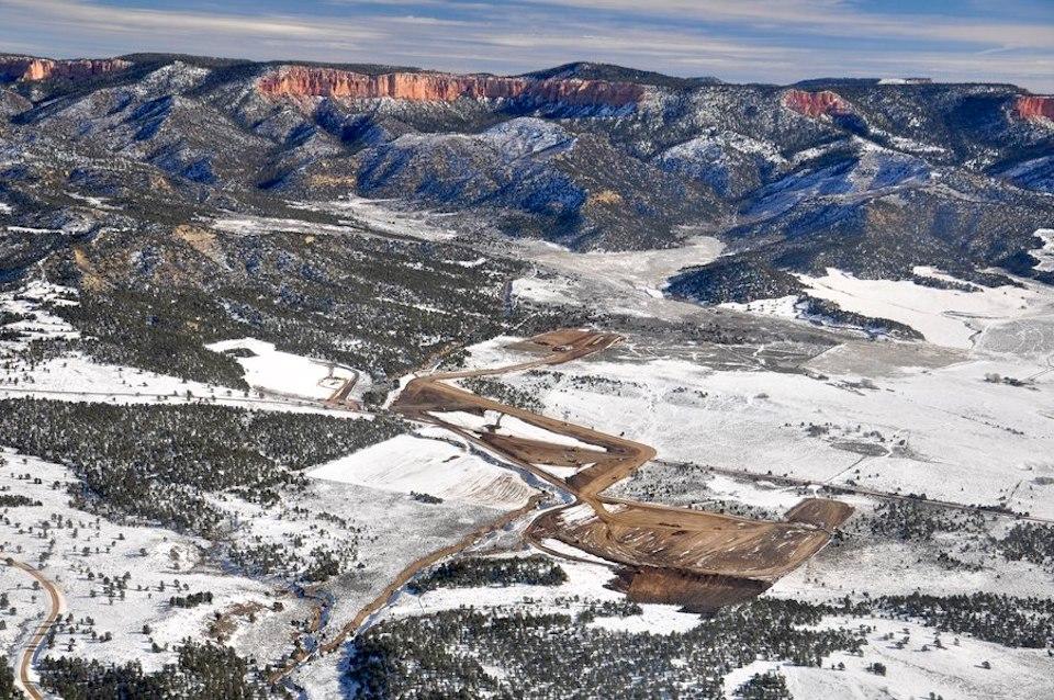
Aerial view of Alton Coal's Coal Hollow Mine site/Southern Utah Wilderness Alliance
The Interior Department has approved the expansion of a coal mine about ten miles from Bryce Canyon National Park in Utah. While the department said approval of the Alton Coal expansion "will further the Administration’s energy dominance and economic prosperity goals," demand for coal has been on a downward slide.
“American coal jobs matter,” Acting U.S. Secretary of the Interior David Bernhardt said late last week. “Coal production on federal lands provides nearly 40 percent of our nation’s coal. By approving these projects today, we will ensure that these mines are operational for years to come, providing well-paying jobs and affordable energy to the people of Utah.”
Park advocates, however, say the administration's move reflects a "war on national parks and public lands."
"Alton Coal Tract poses direct threats to the landscapes, air and pristine night skies at nearby Bryce Canyon National Park, a revenue-generating engine for the region, supporting thousands of jobs and welcoming 2.6 million visitors each year," said Cory MacNulty, the National Parks Conservation Association's associate director in its Southwest Region. "Today’s announcement by the Interior Department foreshadows the attacks on our parks and public lands to come, under proposed Interior Secretary David Bernhardt.”
The Coal Hollow Mine developed by Alton Coal went into production in 2010. Just a year later, the company sought permission to expand its operation to more than 3,500 acres. How expansion, if it occurs, impacts the region's tourism industry remains to be seen.

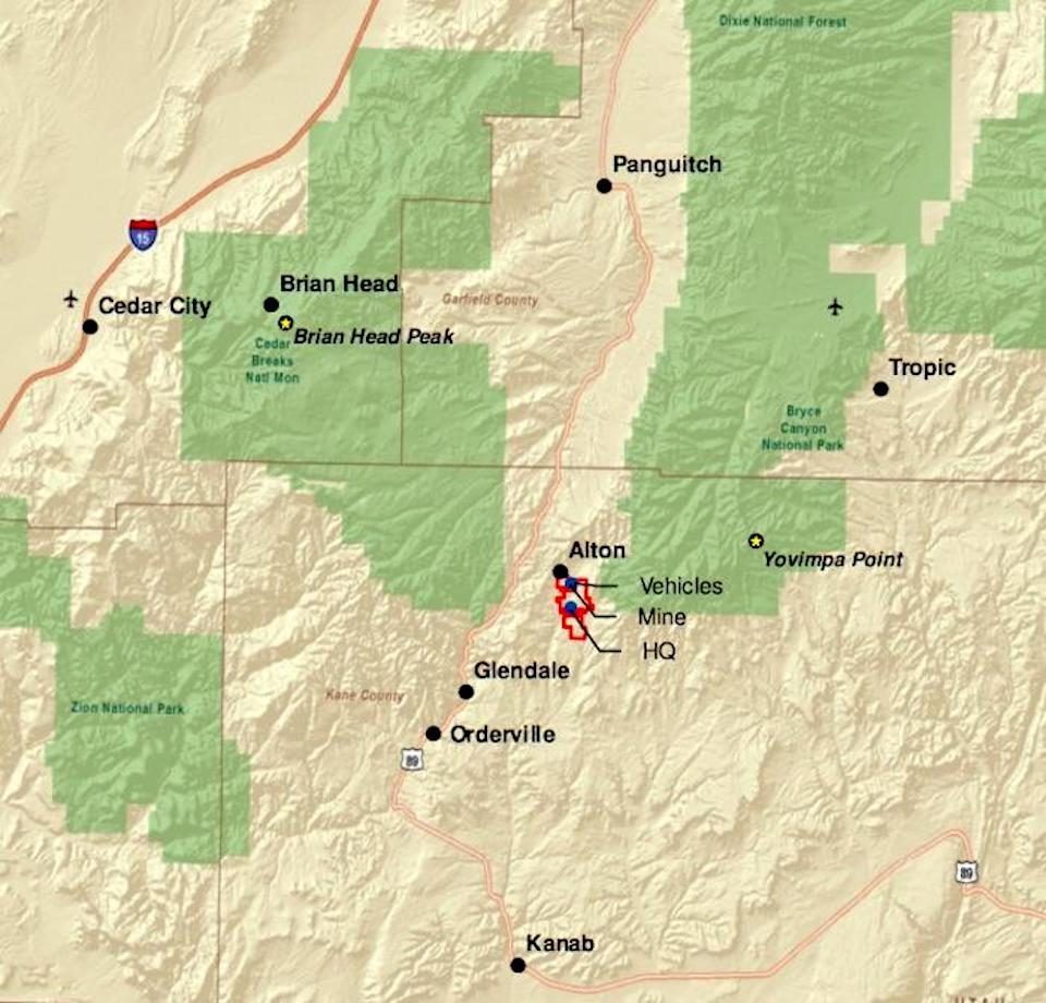
Coal Hollow Mine locator map/BLM
Alton Coal has proposed running coal trucks 10 minutes apart 24 hours a day, six days a week from the mine. Their route would take them 30 miles north on U.S. 89 to Panguitch, and then west on State Route 20 to Interstate 15, and then south to a location near Cedar City where the company envisions a railhead to send the coal to the West Coast.
Both 89 and 20 are winding, rolling, two-lane routes that pass through broken forests of pine, juniper and aspen as they connect Zion National Park, Bryce Canyon National Park, and Cedar Breaks National Monument. During summer those roads are full of tourist traffic that includes a good number of ponderous recreational vehicles. In Panguitch, which funnels south-bound traffic to Bryce Canyon, U.S. 89 goes through the middle of town and requires a 90-degree turn for both north-bound and south-bound traffic.
In studying the expansion, BLM staff noted there were issues with it. Business owners in Panguitch have voiced concerns at such an increase in coal truck traffic, the agency's Final Environmental Impact Statement noted. In the past, Dixie National Forest staff expressed concerns how the mine could impact air and water quality in the forest and impact scenic visitas and wildlife habitat.
Latest economic figures show the tourism industry greatly dwarfs the coal industry in Utah, generating $9.1 billion in overall traveler spending vs. $600 million in coal production.


 Support Essential Coverage of Essential Places


Comments
Those of you who love our National Parks yet voted for Trump share the blame. Elections have consequences. We have a chance to vote for a real president next year. Trump and his swamp creatures like David Bernhardt need to go.
I'm just a little curious where the market is for this coal? California doesn't want it. There don't appear to be any ports in California willing to ship it overseas. This from the Salt Lake Tribune last summer:
According to the same story, Utah apparently has signed an MOU with Mexico to possibly develop a port there. Any railway experts out there who can say whether there's a rail connection between Cedar City, Utah, and Mexico? At the same time, is there a coal loading facility at Cedar City?
Good article - thank you.
FYI - technical matter: the aerial view credit appears to reference SUWA, Southern Utah Wilderness Alliance (not "association" as stated).
Thanks Dean. Not the first time we've made that mistake.
Kurt--
{edited to fix misspelling of aerial and border. Dang I can't spell...}
Al is certainly the railroad expert around here, but I can give partial answers, especially since those are very similar to the questions I had about where the coal would go. tl;dr: exporting via Ensenada makes no sense to me.
No, there's not a rail coal loading facility in or near Cedar City. The mines near Cedar City are hard rock metal mines with spur lines, but likely ship only modest amounts of ore (more likely leaching and concentration near the mines, based on the aerial imagery). I don't think the ability to load truckloads of coal onto unit train is expensive to build, that's what most coal mines have from mine trucks to rail (look at 39.575N -111.913W near Levan for such a facility: inexpensive but dirty). My guess is that the current coal goes to Intermounain Power by Delta or the generating plant near Moapa, NV, or something smaller & closer. LA cut loose Intermountain Power and it's closing the coal generating station by 2025, attempting to convert to natural gas (and building a square mile of solar to hook up to the existing transmission lines).
The rail line in Cedar City wends through the west desert to hook up to the old UP Las Vegas - SLC mainline at Lund. The Utah agreements are with the port of Ensenada and the newspaper articles mention San Diego, so that route would be SW through Las Vegas & Cajon Pass, then through LA to San Diego and Tijuana on tracks that are owned by the public North County Transit District. With 20+ passenger trains per day, freight travels only at night. With coastal bluff erosion in Del Mar requiring re-routing of tracks in the next 5-20 years (at a cost of several billion), and shutting down passenger trains for half a day of inspection after each bluff collapse, there's no way NCTD will allow heavy coal unit trains on their track. Then, of course, the tracks are currently blocked at the border. But, on the Mexican side, the railroad doesn't get within 80 miles of Ensenada: from Tijuana it heads east to Tecate and Campo, where it once again crossed into the US (the old San Diego & Arizona Eastern Railroad). So, getting coal to Ensenada would require either loading coal from trains to trucks in San Ysidro (San Diego), where there's no available real estate for such a plant, let alone tolerance for the dirt and noise, then trucks across the border through downtown Tijuana (every 10 minutes 24/7 or convoys of trucks when each unit train arrives), or building of a rail line through rough terrain to Ensenada. I guess an alternative would be trains turning east at San Bernardino to the border at Calexico/Mexicali, then trucks 150 miles through a couple of passes or 210 miles relatively flat from Mexicali to Ensenada.
Guyamas in Sonora has coal loading in it's port, and would be accessible via the crossing at Nogales. Or, at least for now, possibly Tehachapi Pass north instead of Cajon Pass south, then export via Stockton. Or possibly north from Lund to Tooele, then Ogden, Pocatello, and something on the Columbia River. The Ensenada "informal agreement" sounds more like the recent railroad scams (reopening the SD&AE) than a serious plan to ship coal to Asia.