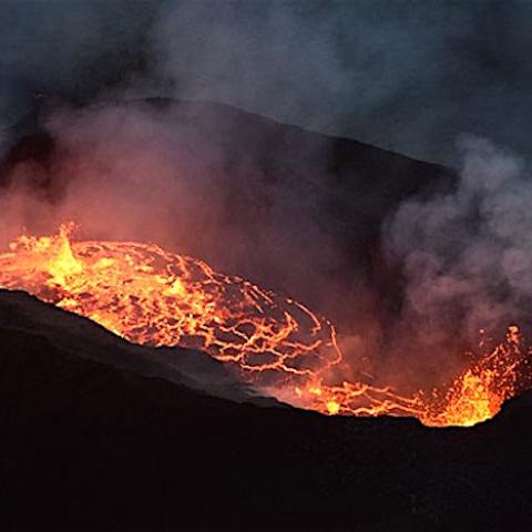
Aerial view of the Kīlauea summit eruption from a Hawaiian Volcano Observatory overflight at approximately 11:20 a.m. HST Monday. The two active fissure locations continue to feed lava into the growing lava lake in Halema‘uma‘u crater, with the northern fissure (pictured right) remaining dominant/USGS, M. Patrick
New eruptions of Kīlauea Volcano at Hawai'i Volcanoes National Park add a dramatic glow to the year-end, and while the park is open 24 hours a day staff asks that you view the activity carefully and from designated areas.
The latest eruptions began Sunday night in Hawaii following a series of earthquakes. The U.S. Geological Survey's Hawaiian Volcano Observatory recorded a magnitude-4.4 earthquake located beneath Kīlauea Volcano's south flank on Sunday at 10:36 p.m. HST. The earthquake was centered about 8.7 miles (14 kilometers) south of Fern Forest, near the Hōlei Pali area of the national park at a depth of 4 miles (6 kilometers).

Dawn arrives Monday at Kīlauea's summit, where scientists are monitoring the new eruption within Kīlauea caldera. Since Dec 20 (~9:30 pm), 3 fissure vents on the wall Halemaʻumaʻu crater have fed lava into a growing lava lake/USGS
The agency said Monday that "(T)hree vents in the wall of Halemaʻumaʻu crater (are) generating lava flows that are contributing to a growing lava lake at the base of Halemaʻumaʻu crater. The eruption is currently confined to Halemaʻumaʻu crater."
According to the USGS, the eruptions boiled away a lake that had formed on the floor of the Halemaʻumaʻu crater following the months of eruptions in 2018.

View from the W rim of Kīlauea Caldera just before 5 a.m. HST on Dec. 21, 2020. The main fountain height is ~18 m (59 ft) and with two other fissures feeds a growing lava lake at the base of Halemaʻumaʻu crater/USGS
Park staff said Monday afternoon that the eruption was drawing hundreds of visitors "eager to see the billowing plume of gas and steam by day and the reflection of glowing lava deep within the crater after dark."
“The return of lava to the summit of Kīlauea is a natural wonder, but we need the public to be fully aware that we are in the middle of the COVID-19 pandemic and to recreate responsibly, maintain social distance and to wear a mask,” said Hawaiʻi Volcanoes Superintendent Rhonda Loh.
“We want to keep the park open for all to experience this new phase of volcanic activity, and we need visitors to follow safety guidelines that keep everyone safe. We continue to work with USGS scientists to receive the latest volcanic updates, and remind visitors that the eruptive activity and accessibility could change at any time,” Loh said.
All areas of the park that were open prior to the new eruption remain open. Vantage points for viewing the latest event include Wahinekapu (Steaming Bluff), Kīlauea Overlook, Keanakākoʻi, Waldron Ledge and other overlooks along Crater Rim Trail, the staff said.
Kīlauea's south flank has been the site of over 30 earthquakes of magnitude-4.0 or greater during the past 20 years. Most are caused by abrupt motion of the volcano's south flank, which moves to the southeast over the oceanic crust. The location, depth, and waveforms recorded as part of today's earthquake are consistent with motion along the south flank detachment fault.
During 2018, Kīlaeau started erupting in early May and continued into August. Some of the more violent eruptions and lava flows destroyed hundreds of homes and structures below the volcano, redesigned the Halema‘uma‘u Crater, and greatly damaged park infrastructure.
"The 2018 lower East Rift Zone eruption and summit caldera collapse marked the end of the 35-year-long Puʻu ʻŌʻō and 10-year-long summit lava lake eruptions, and the beginning of a new chapter in Kīlauea Volcano activity," USGS said last week.


 Support Essential Coverage of Essential Places


Add comment