North of the Arctic Circle, our Twin Otter soars over the Mackenzie Delta’s maze of waterways and patchwork of tundra, darts across the Beaufort Sea and passes over the British Mountains before shaking and shuddering its way down to Sheep Creek International Airport. Well, that’s what the hand-painted sign says at the end of the grassy wilderness landing area. Parks Canada marks the spot as Imniarvik base camp in Ivvavik National Park, a place that just 100 or so people get to see each year in the extreme northwest corner of the Yukon.
Ivvavik means “a place giving birth, a nursery” in the Inuvialuktun language. It’s the traditional calving grounds of some of the Porcupine Caribou herd — who migrate here from their winter ranges in Alaska — and the area where the Inuvialuit (the Inuit people of the Western Canadian Arctic) have come for thousands of years to live off the land.
A gift to Canada under the Inuvialuit Final Agreement of 1984, Ivvavik is the first national park in Canada created as part of an Indigenous land claim settlement with the federal government. It’s cooperatively managed by Parks Canada and the Inuvialuit of Aklavik, whose joint vision for the park states that: “The land will support the people who protect the land.”
Here to protect the land in late June are two Parks Canada staff — site manager and bear monitor Nelson Perry and interpretation officer Rachel Hansen — plus cultural host Renie Arey and cook Nellie C. Elanik from the Inuvialuit community.

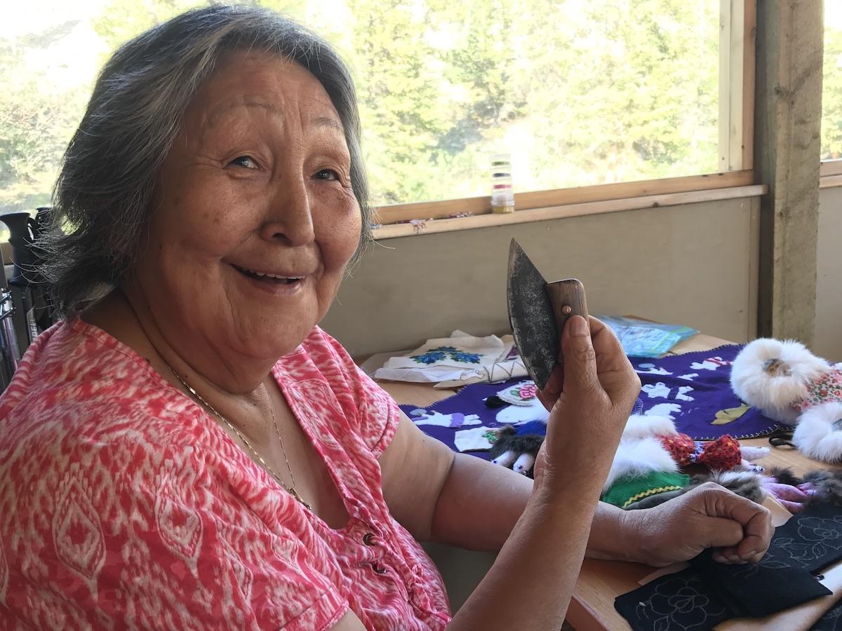
Inuvialuit cultural host Renie Arey shows off her ulu (a traditional knife) at Imniarvik base camp/Jennifer Bain
“I love this place,” says Hansen, who is also Inuvialuk and the young mother of a growing family. “I think it puts some things in perspective. Your problems don’t seem as big.”
How could they in the face of 9,750 square kilometres (3,765 square miles) of wild, remote and unglaciated wilderness with more wildlife than people and no cell or internet service?
Before long, we’ve toured the base camp, been briefed on the electrified bear fences, scoped out the outhouses, admired Ivvavik’s only flush toilet and hot shower, tucked our belongings into furnished prospector tents, been gently reminded not to go off by ourselves because of grizzly bears, eaten the first of four fabulous dinners in the bunkhouse, started getting to know each other (on the visitor front we are three Quebecers, two Ontarians and an Albertan) and been told it’s already 9 p.m.
“Time is already starting to not mean much,” offers Perry.
The Yukon calls itself the Land of the Midnight Sun because the sun doesn’t set from the summer solstice in June until September. In Ivvavik, 24 hours of sunshine will open up the evenings for adventures. The only way we will know for sure that it’s morning is when Arey says “uvlaami” — a lilting word that means good morning in Inuvialuktun.

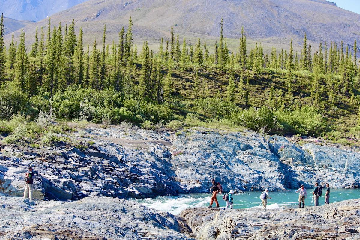
A June hike in Ivvavik National Park, with Imniarvik base camp in the distance/Jennifer Bain
The Inuvialuit — who trace their origins to the Thule culture that developed in Alaska and spread east — love this biologically and culturally rich land and want to protect it from oil and gas reserves and potential pipelines. Eight different cultures have used the area during the last 8,000 years. The Inuvialuit maintain wildlife harvesting rights for subsistence needs within the park and help protect the caribou calving grounds. Aklavik is the gateway community for Ivvavik and the hamlet’s 600 people have a strong traditional connection to the isolated land.
“It’s a pretty stunning landscape,” says Michael Blyth, operations manager for Parks Canada’s Western Arctic Field Unit. “The remote and rugged lifestyle isn’t for everybody, so you have to be comfortable with being that far from the nearest amenities, wildlife may be in the vicinity and rescue may be days away.”
Ivvavik lies on the Yukon North Slope between Alaska and the Northwest Territories and is part of a network of protected areas full of important wildlife habitat and Indigenous archaeological sites. To the north is the Beaufort Sea and Herschel Island-Qikiqtaruk Territorial Park, and to the south is Vuntut National Park. Alaska’s Arctic National Wildlife Refuge is on the west and the Babbage River is the eastern boundary.
Ivvavik has open tundra of the coastal plain, alpine tundra of the British Mountains, forested taiga ecosystems that are a transition between the boreal forest and Arctic tundra, freshwater lakes, rivers and wetlands, and brackish estuaries of rivers that empty into the Beaufort Sea.

Our small group of visitors, and our hosts, by the Firth River/Jennifer Bain
In a 10-year management plan released in 2018, Parks Canada says Ivvavik’s main purpose is the conservation of wildlife, habitat and traditional Inuvialuit use, but it’s also “recognized as a place of experiential learning for visitors about the land and its importance to Inuvialuit culture.”
Parks Canada positions Ivvavik as its “most accessible Arctic national park experience.” It’s not as widely known as it should be, but the agency usually hosts guided summer trips (at reasonable rates) to remote parks across the country.
Many people fly to Ivvavik on guided or self-catering base camp visits, but some camp elsewhere in the park and many come along the Firth River, with its world-famous Class IV rapids, with commercial and private rafting guides.
Between 2010 and 2019, Ivvavik saw an average of just 114 visitors a year, with a low of 78 and a high of 149, numbers that include a youth camp and management board members but not researchers or staff. Base camp trips only started in 2012 and didn’t run last year because of pandemic travel restrictions. Five summer trips can still be booked by residents of the Northwest Territories (who can fly to Ivvavik from Inuvik) for 2021, but people are being encouraged to consider 2022 instead. Canadians typically account for 80 to 90 per cent of base camp visitors. Winter visits — defined here as mid-September to May — are rare.

One of the furnished prospector tents at Ivvavik's base camp/Jennifer Bain
My five-day trip begins with a charter out of the Northwest Territories town of Inuvik, population 3,450. Only nine visitors at a time can come on the guided trips in late June and early July, and they spread out over six Fort McPherson prospector tents, three with queen beds and three with bunkbeds, all with linens, propane heaters, bug nets and decks.
Alberta travel writer Leigh McAdam of Hike Bike Travel, and the three Quebecers— retired geographer Gilles Lemieux, his wife Lorraine Couture and their friend Jean Vallée — are here to hike on trails that have names but are really just approximate routes that follow landmarks.
On the easygoing Sheep Slot hike, we run into plenty of Dall’s sheep, with their snow-white fur and curled horns.
On the Gordon’s Food Cache/Trapper’s Campsite hike, we grapple with unexpected heat, mosquitos and deer flies, plus tussocks and hummocks (tundra lumps, with and without grass, that are common in permafrost environments and are challenging to walk on) that are offset by a leisurely picnic, a little fishing and evidence of the area’s gold mining phase.

Dall's sheep of varying ages in Ivvavik National Park/Jennifer Bain
I reluctantly skip two longer hikes and miss seeing a few caribou, a grizzly and a Golden eagle because I’ve got stories to write and file by satellite communicator. But the others head out one sunny night to Inspiration Point, a ridge behind an angled outcrop of shale over a Beringian landscape, and on to Wolf Tors. Tors are outcrops of bedrock that form pinnacles on mountain tops and valley sides. They’re fragile and wouldn’t have survived the grinding of glacial ice and so prove this area is part of Beringia. My new friends tackle Ivvavik’s full-day Halfway to Heaven hike that ends at Kisoun’s Rock, a shale formation shaped like a preacher’s pulpit with views of three huge tors.
Ivvavik lies within the Beringia Refugium, according to the park’s management plan, an unglaciated area that once connected North America and Siberia with a land bridge and kept plant and animal communities alive. Because the area wasn’t glaciated during the last ice age, the Firth River is one of Canada’s most ancient rivers and several archaeological sites are among the oldest in the Canadian Arctic.
Just outside base camp, I cast into the water where Sheep Creek meets the Firth River in search of colourful Dolly Varden char. It's just before midnight on July 1 and Canada is about to turn 150. I’m treated with the spectacle of two Arctic grayling swirling in an unusual circle, chasing each other’s tails as they float downstream, swimming back upstream and doing it again and again.
I eat Elanik’s memorable cloudberry trifle, spot some of the park’s 147 bird species and watch playful Arctic ground squirrels (siksiks) during my time in Ivvavik, but can’t find voles, lemmings or the famous caribou that pass through in early June. I make do on that front with Parks Canada footage from 34 motion-activated wildlife cameras and a BBC documentary about the caribou migration.

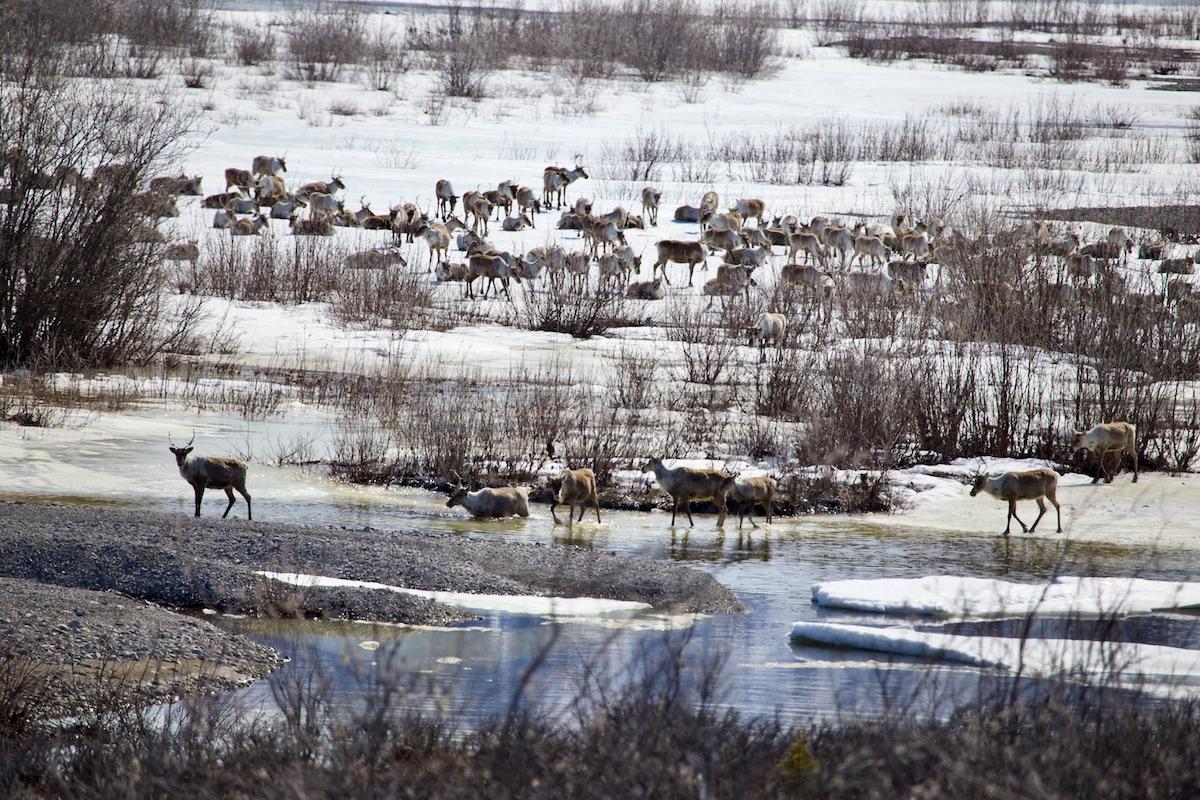
Some of the Porcupine caribou herd arrives to their summer calving grounds in Ivvavik National Park/Parks Canada
According to the Porcupine Caribou Management Board, the herd usually fluctuates between 100,000 and 200,000 and nobody knows why. Still, it’s one of the largest migratory barren ground caribou herds in North America and the top predators are Golden Eagles, wolves, grizzly bears, wolverines, mosquitos and people. Researchers try to conduct a caribou census every second year, plus annual aerial surveys to check on cows, calves and bulls.
Ivvavik strives to play a role in global conservation issues such as wildlife protection and climate change. Researchers have done wildlife population surveys for the caribou, muskoxen, moose, Dall’s sheep, raptors and breeding birds. They’ve also done sea temperature and storm surge monitoring, vegetation and terrain surveys, weather and permafrost monitoring for climate change, water quality monitoring, and an archaeology salvage project.
Coastal erosion is a pressing issue and shorelines can erode up to nine metres (30 feet) each year. Parks Canada has partnered with the Alfred Wegener Institute to investigate the impact of erosion on Ivvavik’s cultural resources, including sod houses, cabins, graves and a Hudson’s Bay Company trading post. The institute predicts that more than half of the Yukon North Slope’s cultural sites will erode by 2100.

Ivvavik has tors — outcrops of bedrock that form pinnacles on mountain tops and valley sides/Parks Canada
But what’s only getting stronger is Ivvavik as a place where the Inuvialuit can reconnect with their cultural traditions and pass on their love of this land to the next generations and visitors. We ponder this over an Inuvialuit dart game called napaatchak, throwing tiny “harpoons” (nails in a wood handle) at a cardboard box and trying to make them stand up.
"Do you believe in magic?” asks Hansen, who feels a spiritual connection to her ancestors when she visits. ““This land is magical."
Arey shares how she was sent to residential school and lost her language when she was young, but reclaimed it, raised seven children, became a field worker and helped with the land claim agreement. The woman who survived tough times by eating ptarmigans and siksiks celebrates every animal sighting we have. “I’m so happy they came to show you how we survived on this land for so long,” she says. “We’re just like farmers but we have to go out there and look for our food and thanks to them we are here today. I’m glad people are starting to understand what our ancestors went through.”

Cook Nellie C. Elanik, Parks Canada's Guy Thériault and Inuvialuit cultural host Renie Arey at Ivvavik National Park's Sheep Creek International Airport sign/Jennifer Bain
Dean Arey, another Inuvialuit cultural host who worked two summers at Ivvavik, still “lives off the land about 75 per cent” and likes to tell visitors about “following the food chain,” foraging, hunting, trapping, fishing and whaling, as well as his passion for drum dancing. While he later tells me that Ivvavik “is a beautiful place to wake up to,” he also fears that climate change is making the water higher, the fish harder to catch, the weather more unpredictable and the winds stronger. The wildlife, though, are thriving.
When it’s time to leave, I watch the Twin Otter circle the area several times to gauge the wind direction before collecting us and dropping off the next batch of visitors. Renie Arey sings an emotional goodbye song and thanks us for honouring her home.
“Do enjoy — this is a beautiful land,” she says, urging us to stare out the plane window and to “always be on the lookout.”

 Support Essential Coverage of Essential Places


Comments
The ulu as shown cannot be "traditional" as it has a metal blade and metal rivets. Sorry.