Avalanche terrain maps are now posted at popular trailheads in the Long Range Mountains of Western Newfoundland/Avalanche Canada
Avalanche Canada will publish Newfoundland and Labrador’s first avalanche forecasts starting this weekend.
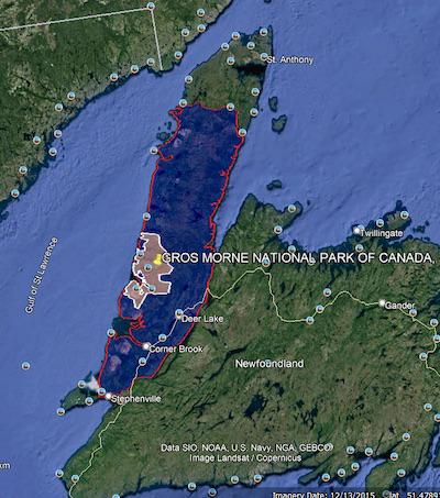
This pilot project promises weekend forecasts for the Long Range Mountains — including Gros Morne National Park — from Feb. 18 to March 26.
“Avalanche Canada is proud to expand its reach by providing avalanche forecasts in Canada’s easternmost province,” its executive director Gilles Valade said in a news release. “These forecasts will give residents and tourists a valuable tool to plan safe trips into the province’s dramatic winter backcountry.”

New avalanche forecasts include Gros Morne National Park/Avalanche Canada
An avalanche forecast provides information about avalanche danger for a given mountainous area over a certain time. It features danger ratings, avalanche problems and details on snowpack, avalanche observations and weather. Forecasts will be published on Fridays and Saturdays at around 5 p.m. local time, on avalanche.ca/nl and the Avalanche Canada app.
Winter backcountry recreation is growing in the province and so more people are recreating in avalanche terrain. Snowmobiling has long been popular, with more riders pushing into steeper ground. Backcountry skiing, snowboarding and ice climbing are also growing quickly in popularity, and many people enjoy the mountains on snowshoes.
“Visitor safety is a top priority for Parks Canada and the information supplied by Avalanche Canada through these forecasts will be an excellent resource for visitors planning winter activities in Gros Morne National Park,” says Tambrae Knapp, acting field unit superintendent for Parks Canada in Western Newfoundland and Labrador. “The park offers a variety of winter recreation opportunities. Having access to this tool and the educational resources available on the Avalanche Canada website will help visitors in their decision making as they plan their winter adventures.”
The forecasts will be informed by Avalanche Canada’s Newfoundland and Labrador field team, based in Rocky Harbour. This two-person team collects snowpack, weather and avalanche observations, and will work with forecasters in Revelstoke, British Columbia to develop the weekend bulletins. It will share its observations and photos on its Facebook and Instagram pages.
“Having grown up in Deer Lake, it gives me great pleasure to help produce avalanche forecasts in my home province,” says Andy Nichols, Avalanche Canada’s Newfoundland and Labrador field team leader. “More and more people are recreating in our mountains each year, and I want to make sure they do so safely.”
Avalanche Canada is hosting a webinar on the forecast program on Feb. 17 at 7 p.m. NT. Register at avalanche.ca/events.
Avalanche danger is rated on a five-point scale of low, moderate, considerable, high and extreme. Each level is defined by the likelihood of avalanches and their expected size and distribution.
Avalanche problems show what kind of avalanches are expected, where they are most likely to be triggered, how likely they are to be triggered and the expected size. There are eight avalanche problem types that are used in forecasts.

Peter Thurlow and Andy Nichols are based in Rocky Harbour for Avalanche Canada/Avalanche Canada
In 2019, Avalanche Canada published specialized maps with terrain ratings for some of the more popular riding areas in the Long Range Mountains. These maps use the Avalanche Terrain Exposure Scale (ATES), which uses a three-point system to rate popular backcountry areas based on the potential for avalanches. The maps are posted at popular trailheads and are included in the online trip planner.
• Simple terrain contains little or no avalanche terrain and there are many options to reduce exposure.
• Challenging terrain contains well-defined avalanche paths and exposure can be reduced with careful route finding.
• Complex terrain is exposed to multiple avalanche paths and minimal options to reduce exposure.
For more information, see Avy Savvy, an online tutorial.

 Support Essential Coverage of Essential Places


