
Fountains of lava rising above 80 feet from Mauna Loa on Tuesday/USGS, L. Gallant
A slow motion eruption of sorts continued Wednesday on the Mauna Loa volcano in Hawai'i Volcanoes National Park, with a sluggish stream of lava heading towards a highway that bisects the Big Island. The eruption, which began late Sunday night, was confined to the Northeast Rift Zone of the world's largest active volcano.
On Wednesday morning the staff at the Hawaiian Volcano Observatory identified two active fissures that were bleeding lava. The flows from Fissure 3 were travelling to the northeast, though the direction shifted slightly westward overnight, the observatory staff reported.
"Fissure 3 is the dominant source of the largest lava flow, and the flow front is about 3.6 miles (5.8 km) from Saddle Road as of 7 a.m. HST this morning," the observatory reported. "The flows have been advancing at a rate of 0.08 miles per hour (130 meters per hour) over the last day, but they are approaching a relatively flat area and will begin to slow down, spread out, and inflate. Forecasts indicate it may take two days for lava flows to reach Saddle Road.
"Fissure 4 is still active with lava flows moving toward the northeast at 0.03 miles per hour (50 meters per hour). A small lobe is moving to the east from fissure 4 at a slower rate than the main lobe. Volcanic gas plumes are lofting high and vertically into the atmosphere. Pele's hair (strands of volcanic glass) is falling in the Saddle Road area," the release said.
Saddle Road, aka the Inouye Highway, runs east-west across the Big Island from Hilo on the east to a junction with Hawaii Route 190 near Waimea on the west.
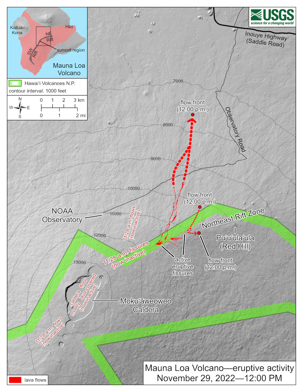
Overnight satellite views allowed USGS analysts to accurately map some of the most active flows, displayed in red here. Further downslope progression of the flows Tuesday morning is marked by dashed lines and points for the flow fronts at 12 p.m. Tuesday
According to the observatory, low-energy earthquakes continued to shake Mauna Loa, which "indicates that magma is still being supplied, and activity is likely to continue as long as we see this signal."
"There is no active lava within Moku'āweoweo caldera, and the Southwest Rift Zone is not erupting," the staff added. "We do not expect any eruptive activity outside the Northeast Rift Zone. No property is at risk currently."
Like its sister volcano to the southeast, Kīlauea, Manua Loa is a shield volcano. As such, for the most part its activity generally is not the explosive type with incinerating pyroclastic flows. Instead, the volcano is one steadily built by subsequent mound-building flows.
Rising more than 2.5 miles (4 kilometers) above sea level, Mauna Loa is the largest active volcano on Earth. According to the USGS, the Hawaiian name "Mauna Loa" means "Long Mountain." It has erupted more than 33 times since its first well-documented historical eruption in 1843, according to the agency. "It has produced large, voluminous flows of basalt that have reached the ocean eight times since 1868. It last erupted in 1984, when a lava flow came within 4.5 miles (7.2 kilometers) of Hilo, the largest population center on the island."
Mauna Loa contains about 9,700 cubic miles of rock, and although its summit elevation is 13,677 feet above sea level, it is considerably higher than Mt. Everest when measured from top to bottom (the ocean floor, that is).

Mauna Loa prior to its eruption/NPS, Janice Wei
Back in 2018 the U.S. Geological Survey released its assessment of the most dangerous volcanoes in the United States. Kīlauea was ranked No. 1 overall, catagorized as a "very high threat," while Mauna Loa ranked No. 16, a "very high threat."
Volcanic threat, as defined by Ewert (2007), is the combination of 24 factors describing a volcano’s hazard potential and exposure of people and property to those hazards (independent of any mitigation efforts or actions). Prompted by the growing global recognition of airborne volcanic ash to enroute aviation, the 2005 U.S. threat assessment was the first time that hazards to aviation had been taken into account in any national-scale volcanic hazard or risk assessment and prioritization schema. The 24-factor threat assessment was designed to account for the highly variable knowledge of the eruptive histories of the more than 160 active U.S. volcanoes, and the diversity of eruptive styles and geographic settings of U.S. volcanoes, as well as to be easily understood by nonspecialists. -- USGS
Kīlauea justified its ranking in 2018, when it started erupting in early May and continued into August. Some of the more violent eruptions and lava flows destroyed hundreds of homes and structures below the volcano, redesigned the Halema‘uma‘u Crater, and greatly damaged park infrastructure.
During the eruptions, nearly 13 square miles of the island were covered by the lava flows, which also forced thousands to evacuate their homes; more than 700 homes were destroyed by the eruptions. Damage estimates ran to at least $100 million, with Crater Rim Drive in the park significantly cracked and buckled while the park's Jagger Museum sustained significant structural damage from thousands of related earthquakes.


Add comment