
I spy with my little (telephoto) eye: people and big glacier buses exploring the Athabasca Glacier, Jasper National Park / Rebecca Latson
It’s no secret glaciers are receding in this era of climate change and global warming. You might not think that, however, while driving the Icefields Parkway between Banff and Jasper national parks in Canada. Almost every nook and cranny of those snaggle-toothed mountains towering over either side of the highway have a large or small glacier nestled within. One of the most-accessible of those glaciers is the Athabasca Glacier near the southern border of Jasper National Park. According to Wikipedia, the Athabasca Glacier is “one of six principal ‘toes’ of the Columbia Icefield.” You can walk upon this glacier by booking a ride on one of the big-wheeled glacier buses designed for travel out onto the ice, or you can do as I did and hike a short, “moderately challenging” trail to view the toe of the glacier.
Some trails are short. Some trails are a little steep in places. Some trails are more like strolls. This very short trail (0.9 mi / 1.4 km) out-and-back to the toe of the Athabasca Glacier combines all the above. The view is amazing, and perhaps a little disheartening, considering the glacier has receded more than a mile (~ 1.6 km) and lost half of its volume in the past 125 years. That may seem like a long time to you, but it’s just a blip on the geologic time scale.
Athabasca Glacier appears to your left shortly after crossing the border between Banff and Jasper national parks. Across the road and to your right from the glacier is the Columbia Icefield Glacier Discovery Center, where you can purchase hot coffee or hot chocolate on a cold day, buy a meal, roam the gift shop, and purchase a ticket to walk upon the glacier and/or test your fear of heights on the glass-floored Columbia Icefield Skywalk. While I did not walk upon the glacier, I did walk over the transparent glass floor jutting out into a steep canyon back in 2016. I liked it, although it was a vertiginous feeling when I first set foot on that glass.
Turn left onto the road toward the glacier, then make an almost immediate right. You can park in the first lot from which a trail leads to the Athabasca Glacier overview, or pass that lot and drive about a half mile further to parking for the trail to the toe of the glacier. You can hike both trails, if you wish. I did since both are short and present different perspectives of the glacier and landscape. The shorter trail is quite level with packed dirt and gravel most of the way but becoming more uneven and rocky near the end.

The road and parking lots to views of the glacier, Jasper National Park / Rebecca Latson

The shorter trail to a view of the glacier, Jasper National Park / Rebecca Latson

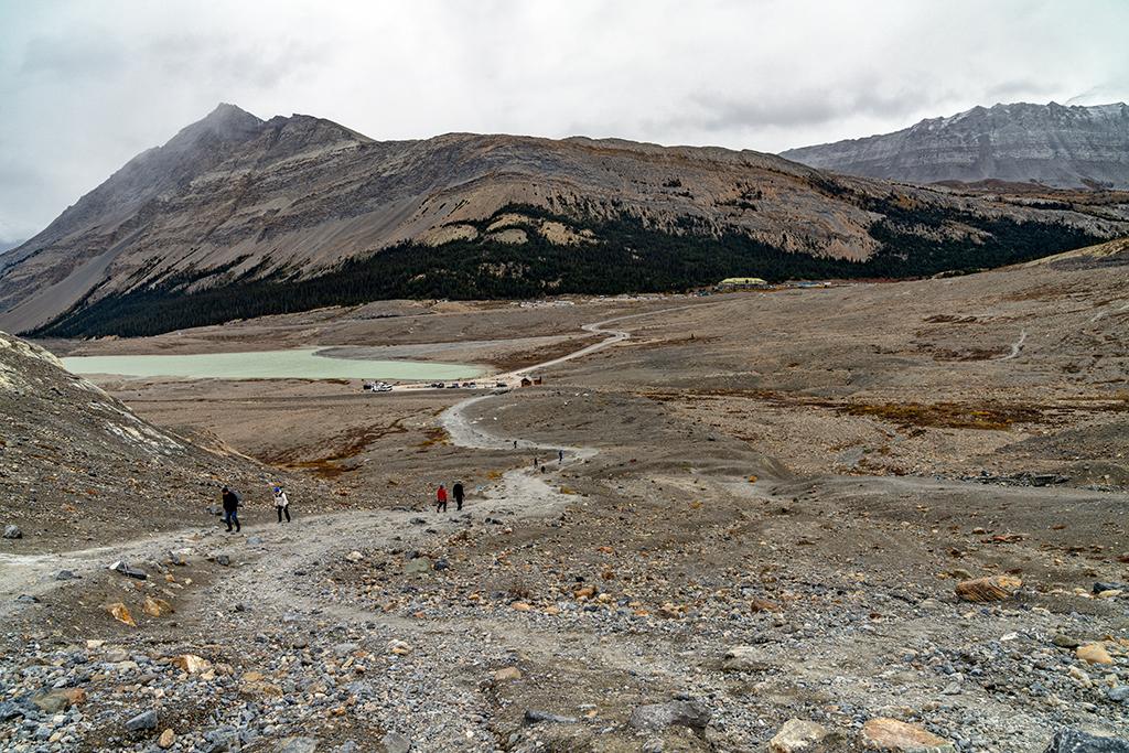
Athabasca Glacier and landscape seen from the shorter trail, Jasper National Park / Rebecca Latson
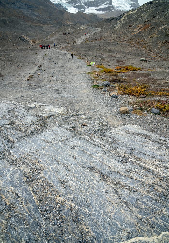
Considered “moderately challenging” due to the steepness at the start of the trail, you’ll be hiking over uneven moraine: the rock and dirt material left behind as the glacier receded. Along the trail are signs marking previous locations of the receding Athabasca’s toe. You’ll also see educational signs along the route (ever heard of a “katabatic wind?”).

Hiking up toward the toe of the Athabasca Glacier. Note the sign indicating where the glacier toe resided in 1982, Jasper National Park / Rebecca Latson
The view down to the parking lot and the Columbia Icefield Discovery Center beyond, Jasper National Park / Rebecca Latson
Take note of the larger rocks embedded beneath your feet. Glaciers are huge, compressed “rivers of ice” plucking out rocks (and everything else) and carrying them all great distances. During glacial movement, the plucked rocks grind, polish, and scratch other rocks beneath. So not only will you see smoothly-polished rocks as you hike the trail, but also striations (straight lines) gouged into the rock representing the direction this glacier moved during its forward and backward travels.
Gacially-polished and -striated rock along the trail, Jasper National Park / Rebecca Latson
Can you tell the direction the Athabasca Glacier moved from the striated rock in this image?
Although still uneven, the trail eventually levels off and descends slightly toward the glacier toe, which is difficult to totally discern since a large line of “terminal moraine” blocks the view. Terminal moraine “consists of a ridgelike accumulation of glacial debris pushed forward by the leading glacial snout and dumped at the outermost edge of any given ice advance,” according to Britannica.com.
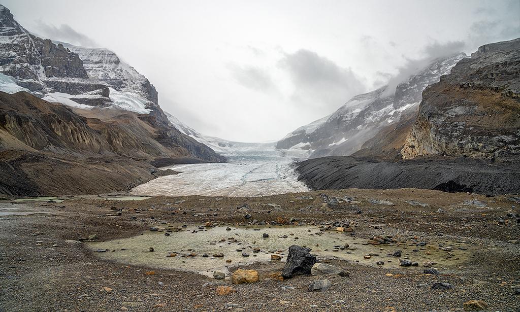
Almost to the Athabasca Glacier's terminal moraine, Jasper National Park / Rebecca Latson
As mentioned earlier, if you want to actually walk on the glacier ice, you can reserve a spot on a glacier bus. You can also reserve a spot on a three-hour guided tour for the same purpose. It’s not a good idea to chance it yourself and continue past the roped-off view area due to hidden crevasses and deep, icy, swift-flowing water concealed beneath thin potions of moraine soil.

Swift-flowing water and terminal moraine at the end of the marked trail, Jasper National Park / Rebecca Latson
The best time to hike this trail is May – September. I took to the trail in mid-September on a cold, windy, rainy day but encountered no problems aside from the temperature. Dogs are permitted on this trail as long as they are leashed.
This is a nice little “leg stretcher” of a hike with an enormous vista at trail’s end of one of the most accessible glaciers flowing from the largest icefield in North America’s Rocky Mountains.

Trail's end for Becky at the toe of the Athabasca Glacier, Jasper National Park / Rebecca Latson


