Editor's note: Volcano Watch is a weekly article and activity update written by U.S. Geological Survey Hawaiian Volcano Observatory scientists and affiliates.
Last week, USGS Hawaiian Volcano Observatory (HVO) scientists were closely monitoring earthquakes and ground deformation in the region southwest of Kīlauea’s summit. The increased unrest prompted HVO to raise the Alert Level/Aviation Color Code for Kīlauea to WATCH/ORANGE on January 31 as another intrusive event began beneath the surface.
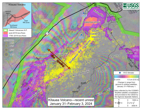
Sources/Usage: Public Domain. View Media Details. This map shows recent unrest at Kīlauea volcano. Yellow circles mark earthquake locations from January 31, 2024, through February 3, 2024, as recorded by HVO seismometers. Colored fringes denote areas of ground deformation over a one-day timeframe from 6 p.m. HST on January 31 through 6 p.m. HST on February 1, 2024. More fringes indicate more deformation. The complex patterns indicate overall deflation of the summit area as magma moved underground to the southwest, where the patterns show uplift and spreading (along with subsidence) due to intrusion of a dike (a vertical sheet of magma).
Earthquake swarms south of Kīlauea caldera began over the weekend, on January 27. This activity was not surprising, as intermittent earthquake swarms have been occurring in the south caldera since October 2023, and there is a known body of magma in this area.
On January 31, however, earthquake activity significantly increased, with over 700 earthquakes detected throughout the day. The number of actual earthquakes was likely much greater, as many of the smallest earthquakes went undetected in the intense swarm of activity.
Coincident with the increased earthquake activity, tiltmeters at Uēkahuna bluff (the summit of Kīlauea) and Sand Hill (southwest of the caldera) began to show changes to the ground surface. Starting just before 4:30 a.m. HST in the morning, the tiltmeters began to show highly variable directions and rates, indicative of crack growth that can precede either an eruption or intrusion. The increased earthquake activity and complex tilt patterns prompted HVO to raise the Alert Level/Aviation Color Code for Kīlauea to WATCH/ORANGE at 4:41 a.m. HST.
HVO seismologists were analyzing earthquake locations in real time. Earthquakes beneath Halema‘uma‘u might signal potential for an eruption there (as occurred in the hours prior to recent eruptions in Halema‘uma‘u). HVO geologists and volcanic gas specialists poised themselves on the rim of Kīlauea caldera, ready to collect data in the event of a new eruption.
However, earthquake locations instead migrated farther to the southwest, along the Koa‘e fault system. By the evening, the tiltmeters showed a more consistent deflationary signal. Together, the two monitoring datasets indicated that magma had opened a new pathway and was moving from the storage system below Kīlauea summit to the southwest.
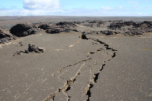
Sources/Usage: Public Domain. View Media Details. On February 3, 2024, a team of HVO scientists documented new ground cracks in three areas of the Maunaiki Trail in the Ka‘ū Desert, caused by the intrusion southwest of Kīlauea's summit caldera. These cracks primarily cut the loose Keanakāko‘i tephra which blanketed the region in 1790 CE. Some cracks were over 100 feet (30 meters) long. Note the person for scale in the right upper portion of the photo. USGS photo by N. Deligne.
On February 2, the numbers of earthquakes began to decrease, along with ground deformation rates. On the morning of February 3, HVO lowered the Alert Level/Aviation Color Code for Kīlauea back down to ADVISORY/WATCH.
While there have been several intrusions in the south caldera region of Kīlauea recently—in December and October 2023, 2021, and 2015—the recent intrusion extended farther southwest, towards Pu‘ukoa‘e and the Kamakai‘a Hills on the Southwest Rift Zone of Kīlauea. As a result of the intrusion, surface cracks, extending tens of meters in length and centimeters (inches) in width, formed in loose Keanakāko‘i tephra along the Maunaiki trail near Twin Pit Craters in the Kaʻū Desert of Hawai‘i Volcanoes National Park.
The south caldera area and Koa‘e fault system are informal names for specific geographic areas that we see on the surface of Kīlauea, but they extend into the subsurface. There is a well-known magma body beneath the south caldera region (the largest magma storage region of Kīlauea) and the Koa‘e faults are structural features related to Kīlauea’s south flank. How these features are connected beneath the surface, to each other, and to the Southwest Rift Zone of Kīlauea is not well-understood.
Intrusions are a common process that volcanoes around the world experience, akin to a pressure-release valve for the magma reservoir. Although there hasn’t been an eruption at Kīlauea since September 2023, the recent intrusion shows us that the volcano has been very busy beneath the surface.


