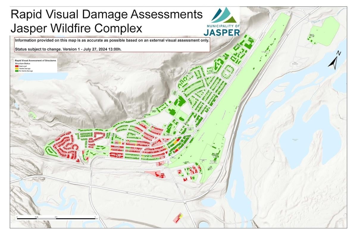
A July 27 map shows which structures in the Jasper National Park townsite were damaged by wildfire.
The Municipality of Jasper has released a map showing the initial damage assessment of structures impacted by the biggest fire to sweep through Jasper National Park in more than a century. About 30 per cent of the town's structures — 358 of 1,113 — were damaged but critical infrastructure was saved.
Given how quickly the wildfire spread last week, many of the town’s 4,000 residents couldn’t get home before evacuating and have been in turmoil over leaving pets behind. A bylaw officer has rescued 15 pets so far.
“I want to extend my heartfelt condolences to everyone who experienced losses,” Jasper Field Unit Superintendent Alan Fehr said in a statement Saturday night. He called the fire “the most devastating wildfire in a Canadian national park’s history.”
Affected residents and business owners, and those with tenant insurance, are encouraged to contact insurance companies. Residents who don’t have tenants insurance can apply for the Government of Alberta evacuation funding organized by the Alberta Government.

The Hinton & District SPCA is caring for 15 pets rescued from Jasper by a bylaw officer/Parks Canada
This wildfire remains out-of-control and is expected to become more active. An initial aerial survey of the perimeter has been conducted and the fire size has been revised down to about 79,000 acres (32,000 hectares). It’s still the largest wildfire in more than 100 years in the Alberta mountain park.
Crews are working along the perimeter closest to town and are planning to create containment lines. Teams are focusing on securing spot fires in priority areas such as the Pyramid Bench Area near the townsite.
Visible structural hot spots within the town have been extinguished. Firefighters continue to patrol for any fire activity with warmer weather and stronger winds. An early morning infrared scan of the town will be done Sunday to provide firefighters with the GPS coordinates of any hidden hot spots.
Structural protection sprinklers are being relocated from previously burned areas to the active fire perimeter next to the community and outlying structures. More structural protection sprinklers are being installed at Lake Edith and businesses north of town.
A night vision helicopter from Alberta Wildfire has been requested. This specialized piece of equipment allows bucketing to happen through the night when wildfire activity is lower. It lets the Unified Command receive real-time, overnight information about the status of the fire.
Bulldozers are preparing to put protection lines around the north end of the community and to help reduce spread west of the community on the lower slopes of Whistler mountain. Areas under consideration also include widening existing fire guards to ensure no further damage to the community.

The town's beloved Jasper the Bear statue has survived. Canadian artist James Simpkins created the character to recognize the importance of environmental stewardship/Parks Canada
The Alberta Government is hosting a telephone and online town hall on Monday night for Albertans who have been evacuated.
The Hinton & District SPCA has donated a van and pet food and is providing shelter for rescued pets until they can be reunited with their families.
Reception centers have been set up in Grand Prairie, Edmonton and Calgary. Teams are developing plans so that evacuees can travel through the park from the Valemount area of British Columbia to Hinton, Alberta to reunite with friends and family. The only way out of the park for many evacuees was west into B.C.
Parks Canada is receiving reports of violations to the the park closure along the Icefields Parkway. While there is no wildfire risk, there are no services available and there's a chance of exposure to wildfire smoke contaminants. Parks Canada Dispatch operations have been impacted, search and rescue services aren't available and no road rescue response is possible.
Reservations for front country and backcountry camping, as well as for Parks Canada accommodations, have been cancelled up to Aug. 6. That date will be reassessed and any future refunds will be automatically handled through the Parks Canada reservation system.
About 25,000 people have been safely evacuated from the park, most of them visitors.

The Jasper Wildfire Complex remains out-of-control but firefighters have been taking adventure of cooler weather to make headway/Parks Canada

 Support Essential Coverage of Essential Places


