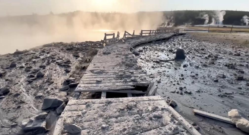
Rocks, mud, and other debris were ejected by the hydrothermal explosion/NPS
Editor's note: This updates with additional details of the explosion from USGS scientists at the Yellowstone Volcano Observatory.
The hydrothermal explosion that rocked Yellowstone National Park's Biscuit Basin tossed rock blocks weighing hundreds of pounds short distances, sent steam and debris hundreds of feet into the air, and changed the personality of two hot springs, according to Yellowstone Volcano Observatory scientists.
National Park Service workers on Wednesday were assessing the damage the explosion did to a boardwalk in the basin, and the park superintendent said the area could be closed to the public for the rest of the year.
As alarming and impressive-looking as it was, the explosion that rocked the basin Tuesday morning and sent visitors running was actually on the "small" size of such explosions, according to the U.S. Geological Survey.
"The explosions can reach heights of 2 km (1.2 miles) and leave craters that are from a few meters (tens of feet) up to more than 2 km (1.2 mi) in diameter. Ejected material, mostly breccia (angular rocks cemented by clay), can be found far as 3 to 4 km (1.8 to 2.5 mi) from the largest craters," notes the USGS.
Measurements of Tuesday's explosion were not immediately available, but Park Service photographs of the site showed how violent the blast was.
“We’re grateful no one was injured in yesterday’s hydrothermal explosion at Biscuit Basin,” Yellowstone Superintendent Cam Sholly told the Traveler on Wednesday morning. “We’re working closely with the team from the Yellowstone Volcano Observatory/USGS (YVO) who are continuing to monitor and at this point do not believe there are any signs of additional unusual activity.”
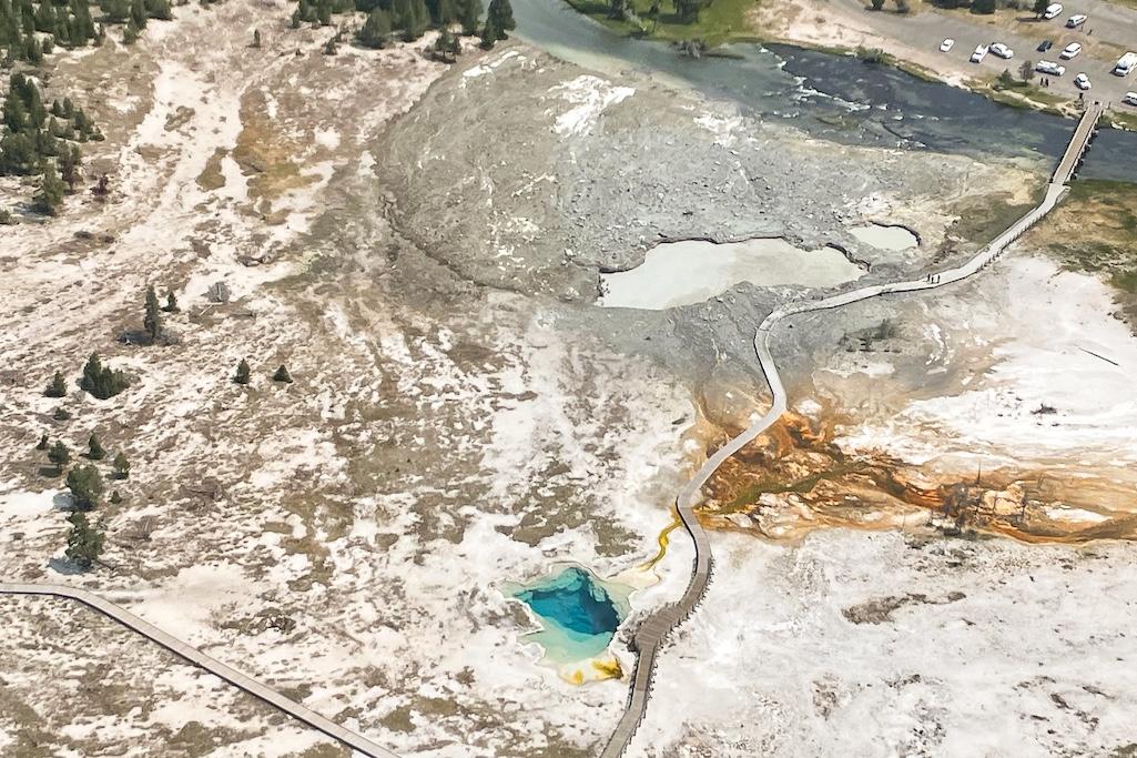
Aerial view of the site of the explosion in Biscuit Basin/NPS
On Wednesday, the USGS provided additional details of the explosion, saying it had sent “[S]team and debris to a height of hundreds of feet above the ground, destroyed a nearby boardwalk and ejected grapefruit-sized rocks tens to hundreds of feet from the source. Some blocks closest to the explosion site are about 3 feet (1 meter) wide and weigh hundreds of pounds. The explosion was largely directed to the northeast toward the Firehole River, and the largest blocks of debris fell in that direction. The dark color of the explosion was a result of mud and debris mixed with steam and boiling water. Although visitors were present at the time of the event, no injuries were reported.”
“Black Diamond Pool and Black Opal Pool were affected by Tuesday’s explosion, and while they remain distinct features, the shape of Black Diamond has changed somewhat," the agency continued. "Both pools are murky due to debris, and the unstable ground around their edges occasionally slides into the water. Just after the eruption, Black Diamond Pool exhibited minor roiling and water spouting. The water level in the pool rose over the course of the day, and by Tuesday afternoon the roiling transitioned to occasional bursts of hot water that reached about 8 feet (2.4 meters) in height."
By Wednesday morning, however, the pool levels had risen above the surrounding crust and sent water overflowing in murky streams down to the Firehole River.
The USGS scientists cautioned that, “[G]iven the recent changes to the hydrothermal plumbing system, small explosions of boiling water from this area in Biscuit Basin continue to be possible over the coming days to months. USGS and NPS geologists will be monitoring conditions, mapping the debris field, and sampling water to assess any changes in the shallow hydrothermal system over the next several days.”
Earlier this week in a column the scientist-in-charge of the Yellowstone Volcano Observatory, Michael Poland, noted that, “[S]mall hydrothermal explosions happen almost annually someplace in Yellowstone National Park—like the 1989 explosion of Porkchop Geyser. Every few thousand years, large ones can also occur. The park is home to the largest-known hydrothermal explosion crater on Earth—Mary Bay, on the north side of Yellowstone Lake, is 1.5 miles (2.4 kilometers) across and formed about 13,000 years ago.”

A 2009 hydrothermal explosion, also in Biscuit Basin, was much smaller than Tuesday's blast/USGS photo
Earlier this year the aftermath of a very small hydrothermal explosion was discovered in the Norris Geyser Basin not too far from a section of boardwalk there. The resulting crater was only a few feet across and surrounded by fragments of silica sinter and disrupted ground.
“Although large hydrothermal explosions are rare events on a human time scale, the potential for additional future events of the sort in Yellowstone National Park is not insignificant,” the USGS says on a webpage explaining hydrothermal explosions. “Based on the occurrence of large hydrothermal explosion events over the past 16,000 years, an explosion large enough to create a 100-m- (328-ft-) wide crater might be expected every few hundred years.”
Sholly couldn’t say exactly how long Biscuit Basin might be closed to visitors.
“It appears that significant amounts of boardwalk were damaged. It is likely the basin may remain closed for the rest of the year, however we’ll know better once the damage assessments are completed,” he said.
 Indian Pond hydrothermal explosion crater north of Yellowstone Lake. The deposits from the explosion that formed the crater were dated with radiocarbon to 2,900 years ago. Photo from Yellowstone")
Aerial photo of the 0.06 square mile (0.16 square kilometer) Indian Pond hydrothermal explosion crater north of Yellowstone Lake. The deposits from the explosion that formed the crater were dated with radiocarbon to 2,900 years ago./NPS file, Jim Peaco


Add comment