
Map of Sunrise area trails, Mount Rainier National Park / NPS file
The Fremont Lookout Trail at the Sunrise area of Mount Rainier National Park in Washington State is an extremely popular hike, and one I’ve been wanting to experience myself for the past six years. I finally hiked the trail during a perfect August day.
Fremont Lookout Trail is accessed by hiking up to Sourdough Ridge from the visitor center/day lodge parking lot, then 1.5 miles (2.41 km) to the five-way trail intersection at Frozen Lake. From there, the trail to the fire lookout, built in the 1930s and the highest of four historic lookouts in the park, is another 1.3 miles (2.09 km). Total out-and-back mileage is 5.6 miles (9.01 km) with 900 feet elevation gain (274 m).
Apart from a couple of steep parts at the beginning, the first leg of the hike to Frozen Lake is relatively level, dusty packed dirt with some rocks sticking up here and there. You’ll walk through a little bit of forest and along rocky crags opening out to meadow views below the trail. Mount Rainier will always be within sight as will other mountains.
This part of the trail affords the hiker wonderful views of sunrise over “The Mountain.” The morning I started my hike, the valleys were filled with thick fog resembling cottony white lakes and rivers.

Sunrise at the Sunrise area of Mount Rainier National Park / Rebecca Latson
Because Frozen Lake is Sunrise’s domestic water supply, a fence encircles the small waterbody preventing trespass by hikers or mountain goats. There’s a rocky area at that five-way trail intersection perfect for resting and deciding which trail to take from there (Burroughs Mountains, Fremont Lookout, Berkeley Park, Shadow Lake-Sunrise Camp, or back to the Sunrise parking area).
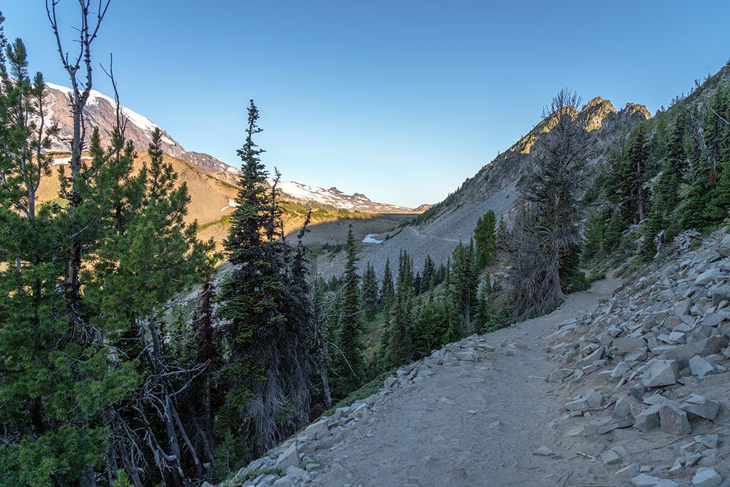
The trail to the Frozen Lake five-way trail intersection, Mount Rainier National Park / Rebecca Latson
Fremont Lookout Trail begins a steady ascent on very dusty, hard-packed dirt around rocky crags with meadowland views below.

The Fremont Lookout Trailhead, Mount Rainier National Park / Rebecca Latson

Looking back down the trail, Mount Rainier National Park / Rebecca Latson
At the highest portion of the ascent, the fire lookout will be in view and the trail changes from dusty hard-packed dirt to dirt and tocks, and finally to nothing but loose rocks the last third of the way.

Onward to the fire lookout, Mount Rainier National Park / Rebecca Latson
Hike around that last knoll and climb the trail of loose rocks for a view of the fire lookout set upon a small knob. You cannot go inside the building, but you can climb the steep stairs and walk around the lookout for exemplary and expansive 360-degree views encompassing Mount Rainier, the Cascades, the Olympic Mountains, and the meadows of Grand Park.

The author at the Fremont Lookout, Mount Rainier National Park / Rebecca Latson
There are rocks for you to sit on and enjoy a snack and water. Just watch out for the cute but pesky and habituated little ground squirrels. These guys are quite aggressive. While I sat fiddling with a camera setting, one squirrel scurried right up to me, circled around, and leaped squarely on my hatted head.
Later, while talking to a volunteer about the squirrel incident, I was given examples of how bad it is to feed the wildlife, no matter how cute. Feeding the squirrels habituates them to humans and makes them aggressive enough to either jump on your back or head, or worse, bite you. Animals carry diseases, including hantavirus and rabies. Human food is not found in the squirrel’s environment, and (believe it or not) they can die from starvation after becoming used to human handouts rather than seeking out what might be found in the wild.
You can find more Trails I've Hiked stories on this page.
I mentioned earlier that the last part of the trail to the fire lookout is nothing but loose rock. It goes without saying you should wear sturdy, protective footwear and watch your step. It’s easy for even the most careful of hikers to lose their footing and stumble on a loose rock. Boots help prevent twisted ankles.
After hiking the Fremont Lookout Trail, I understand why it is such a popular pick among visitors. It’s a moderately-strenuous trail offering awe-inspiring landscape views throughout the hike. There is even the possibility of seeing a herd of mountain goats grazing above or below the meadows around the Frozen Lake portion of the hike.
If You Go:
Trailhead: Take the feeder trail up from the Sunrise visitor center/day lodge parking area to the Sourdough Ridge Trail, turn left and hike the trail to Frozen Lake. At the 5-way trail intersection of Frozen Lake, take the Fremont Lookout Trail. Arrive before 8 a.m. during the summer months if you want a parking spot.
Distance: 1.5 miles (2.4 km) to Frozen Lake, 1.3 miles (2.1 km) to Fremont Lookout (one-way).
Elevation: 900-foot (274-m) elevation gain.
Difficulty: “Moderately challenging” (aka strenuous) due to elevation gain throughout the hike plus loose, rocky terrain near the last third of the hike to the lookout.
Map: click here for a map of the Sunrise area trails and descriptions.

A herd of grazing mountain goats on the meadow above the Fremont Lookout Trail, Mount Rainier National Park / Rebecca Latson


