Foundational ruins on Buxton Beach at Cape Hatteras National Seashore from a former military site/NPS
U.S. Coast Guard officials say that agency is not responsible for hazardous wastes found at Cape Hatteras National Seashore in North Carolina that need to be cleaned up.
Rather, the Coast Guard said, wastes above "maximum containment levels" were left by the U.S. Navy.
The decades-old site at Buxton on the national seashore has been unearthed by coastal erosion and has "tested positive for petroleum-contaminated soils (PCS)," according to the National Park Service. "Additionally, abandoned facilities, construction debris, and septic systems associated with historic use of the area have been observed along the beach and pose hazards to visitors."
The Navy occupied the site from 1956 until 1982, when the Coast Guard took over the grounds and had an active operation there until 2013. Since the Coast Guard operations ceased, the agency has been working on a Comprehensive Environmental Response, Compensation and Liability Act (CERCLA) report to identify what wastes remain on the site and whether they need to be cleaned up.
Last Friday the Coast Guard came out with that report that said varying levels of heavy metals, volatile organic compounds, and chlorinated solvents had been found on the site, but that none of the wastes found above allowed levels were the result from that agency's operations.
Among the report's findings:
- One soil sample (near the southern portion of the former Firing Range berm) exhibited an elevated lead concentration but detected below the EPA Industrial/Commercial RSL.
- Lead was detected in the groundwater sample collected from the former Firing Range Berm (near the central portion of the former Firing Range berm) at a concentration above the [Maximum Containment Level]. Lead was also detected at a concentration above the MCL in the background groundwater sample (OG-TW8), located approximately 300 feet southwest of the former Firing Range.
- Total Arsenic Detections in Soil Total arsenic was detected at concentrations above the Industrial/Commercial RSLs in three soil samples. According to U.S. Geological Survey, total arsenic concentrations in North Carolina soils range from <0.6 to 11.7 mg/kg (USGS, 2013). Total arsenic soil concentrations from the Site are within the USGS North Carolina range. Total Arsenic Detections in Groundwater Total arsenic was detected at concentrations above the EPA MCL in two groundwater samples.
- Diesel range organic and Methylnaphthalene [a chemical compound that is a known carcinogen] were detected at concentrations above the North Carolina Department of Environmental Quality Underground Storage Tank Action Level and Industrial/Commercial RSL, respectively. Due to the presence of shallow groundwater (~5 feet bgs), deeper soil samples were not collected. Methylnaphthalene was detected above the EPA Tap Water Standard in one groundwater sample.
The report said that the elevated lead levels in soils and groundwater at the former Firing Range "appear to be related to former Navy operations." It also said levels of chromium and arsenic found during the testing appear to be naturally occurring.
"The [U.S. Coast Guard] utilized the site from 1982 to 2005 as a logistical, communication, medical, and supply support center and would not have stored or used PFAS-[Per- and polyfluorinated substances] compounds," the report said.

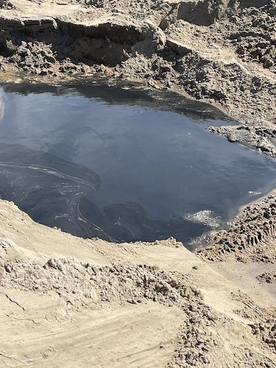
Photo taken October 5, 2024, during the Army Corps of Engineers project to respond to reports of fuel sheen and odors at the Buxton Formerly Used Defense Site/NPS
The report also said that the levels of Methylnaphthalene in groundwater and soil samples "appear to be related to Navy operations..."
"Based on the photo documentation from 1957 and 2013, contamination in this area may have resulted from spills when there was no secondary containment in place," it added.
According to the Park Service, "the former Navy facility property was found to be an Army Corps of Engineers Formerly Used Defense Site (FUDS) property and eligible under the Defense Environmental Restoration Program" for remediation.
Until the cleanup is completed, the seashore staff advises visitors not to swim, wade, or fish in front of Buxton Beach Access.
"Reports of varying mild to moderate symptoms including headache, nausea, and skin irritation have been shared by individuals after participation in recreational water activities in the impacted area," the staff said. "If skin comes in contact with contaminated sediment or water, thoroughly wash the affected area with soap and water."
The Navy operated on roughly 50 acres just north of the Cape Hatteras Lighthouse. From the site the Navy operated an "undersea surveillance station, ... and it is reported that the listening cables that extended from the facility’s terminal building to dozens of miles out to sea, made the first underwater detection of a Soviet diesel submarine in 1962," the seashore notes on its website.
The permit that allowed the Navy to operate there specified that it was to "remove all structures, foundations, and pavements, and clean up and restore the site prior to or immediately following termination of use.”
The permit granted the Coast Guard to occupy the site also required it to remove all improvements it made and restore the grounds to "park land" once it ceased operations.
Seashore staff are reviewing the CERCLA report.

 Support Essential Coverage of Essential Places


