Amid rising water levels, some of the country's oldest and most valuable historical artifacts are at risk of being lost forever.
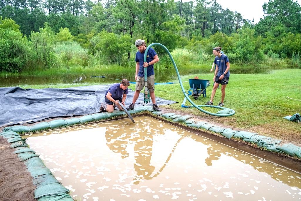
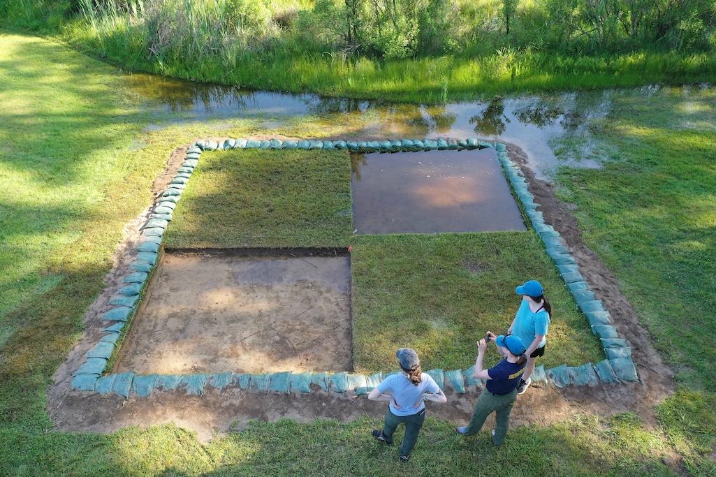
On a partly sunny, early-spring afternoon in tidewater Virginia, a series of rectangular pits offers evidence that something unusual is happening. Scattered several yards apart on a 23-acre property along the James River, the pits range from being totally dry to somewhat muddy and moist—perhaps not that surprising for being only a few feet above sea level. But even in this low-lying environment, one pit stands out: Unlike the rest, it is inundated with water, looking more like a stagnant pond than a site for research and discovery.
This is Jamestown, the location of the first permanent English settlement in North America and a place of active archaeological research, excavation, and preservation. Millions of artifacts have been excavated from the site over the last century, helping historians to understand much of what we know about this historic early settlement. But untold numbers of other artifacts may soon be lost forever because of increasing water levels, not just from flooding but also from rising groundwater and migrating wetland areas. Among the most profound known impacts are the loss of human remains.
Known officially as “Historic Jamestowne,” the site is administered by the Jamestown Rediscovery Foundation, itself part of Preservation Virginia—a statewide nonprofit preservation organization—in partnership with the National Park Service, which co-manages Jamestown Island as part of Colonial National Historical Park.
Historic Jamestowne sits on the southwestern corner of the island, which is connected to the mainland by Colonial Parkway. It encompasses several significant sites, including the locations of the original 1607 Jamestown Fort and a Confederate fort used during the Civil War, the remnants of the 17th century church tower, and the Archaearium, a museum that displays some of the site’s remarkable artifacts—armor, pipes, dishware, religious pieces, and more.
“We’ve lost around a hundred feet of land in some areas due to erosion,” says Sean Romo, director of archaeology for the foundation. “These are kind of the big, major things impacting the ground as a whole, as we would expect—sea level rise, erosion—being on the river. On a smaller scale, we're seeing a lot of damage to archaeological resources below ground.”

The grounds at Jamestown following Hurricane Helene last fall/Jamestown Rediscovery Foundation
An Insidious Threat
The unique ecology of Jamestown Island was a factor in shaping how the original settlers lived and in the impacts it faces today. Despite some upland forested areas, this is a predominantly wetland domain—full of salt marshes and the Pitch and Tar Swamp, from which settlers extracted pitch and tar for use in shipbuilding, that stretches across the island’s interior. Early preservation efforts at Jamestown included the construction of a seawall along the island’s southern edge, which is largely still protecting the site from river overwash, except in extreme storm events. The main threat, according to foundation staff, is actually coming from within—the widening and deepening swamp and a rising water table. Changing ocean dynamics and land subsidence are also factors.
Not far away from Jamestown’s original fort location, Romo points out an excavation of an area that, in the 17th century, was dry enough to use for storage or other things. Now, it’s routinely flooded.
“We’re seeing that, with sea level rise, the tides are coming up,” Romo explains. “But we're also seeing that with the increased rainfall, we're getting a perched water table that is percolating out into the archaeological features.” (A perched water table is a localized area of saturated soil or rock that sits higher than the main water table because of some impermeable layer.)
“This area was dry in 1607,” Romo explains. “They could use it. They could store food down here. And now we've got standing water anytime we have any kind of high tide that affects the swamp back here or heavy rains. And so we actually had to pause on our excavations here a couple of times, because there was water just sitting there and we couldn't see the layers clearly or recover artifacts cleanly by digging. We had to wait it out.”

Flooding in June 2023/Jamestown Rediscovery Foundation
Human Stories
Over the past century, researchers have determined that the average sea level has risen nearly 1.6 feet in the tidewater region of Virginia—a trend that is now accelerating. Studies predict that about 14 of Historic Jamestowne’s 23 acres—or 60 percent—could be permanently underwater within the next 50 years. In a map used by the foundation (and created by engineering consultants VHB) that illustrates relative risk to archaeology under existing site conditions—from red signifying more risk to green signifying less—nearly the entire property is flame-colored.
It’s a problem that is plaguing historic and cultural sites up and down the Eastern seaboard and across the country, but few areas can match Jamestown in terms of historic and archaeological significance. Here lies evidence of human settlement that includes Indigenous peoples, enslaved Africans, and white European settlers, layered over the 418 years since the foundations of modern American society—for better and for worse—were first laid here.
In one section of the site that was a known burial ground—probably dating to the “starving time” winters of the 1610s or 1620s—the archaeologists have discovered human remains that were almost completely disintegrated from being underwater. They suspect that burials might exist across a whole low-lying area of the site that now sees regular flooding, and the risk is that they will soon be lost forever, if they aren’t already. Because of the location, these people likely represented poorer factions of society—people whose lives were already harder to discern in the first place.
“We don't know the limits of that burial ground,” says Michael Lavin, the site’s director of collections and conservation. “Then, at some point they start transitioning to burying folks on their own property, the lower status individuals, so you're looking at enslaved Africans, indentured servants. Those are the ones that would also be buried on those land lots that Sean's trying to work through the deeds and get them assigned onto the landscape. So there's a tremendous potential of research that's being lost by the effects of sea level rise and climate change.”
“And just the human stories,” adds Romo. “The lives they lived, how they died, what they did for a living. All of that, we can access from intact human remains, but we can't if they've dissolved or they're underwater. And all the people who trace their ancestry to here, or have links to Jamestown, many of those folks want to know, what did my ancestor do? Where are they buried? I think we're all very hopeful we can come up with some sort of solution, because nobody wants to say, ‘Well, they were buried out here. Sorry, now it's a pond.’”

In June 2023 tidal flooding inundated a dig site/Jamestown Rediscovery Foundation
Paths to Resiliency
The National Park Service, for its part, is also working to mitigate threats to Jamestown’s cultural resources. Park staff declined to participate in a phone or in-person interview, but in response to email questions, Dwayne Scheid, division lead for the park’s Resource Stewardship and Science Division, says that park staff are “actively working to understand and mitigate the impacts of sea level rise, erosion, and inundation on all park resources, from Yorktown to Jamestown Island, through studies,” and that “the park's collections are currently stored off the island to minimize potential impacts.”
Recent projects, Scheid adds, include work funded by the Great American Outdoors Act for Colonial Parkway improvements to address stormwater management, as well as efforts to stabilize the James River shoreline (and that of the nearby York River), conduct climate change vulnerability assessments on archaeological sites, and monitor groundwater salinization and rising rates, among others.
In October 2022, the Jamestown Rediscovery Foundation issued a comprehensive resilience plan—produced in conjunction with Stemann Pease Architecture and VHB—that outlined the severity of the issues at Jamestown along with some avenues of mitigation. Possible strategies include hardening the shoreline and strengthening the seawall, building earthen berms, improving drainage, and elevating paths and certain landscape areas.
All of this takes money, time, and political and community support, of course, and some of this work has begun to varying degrees. The foundation welcomes donations via its Save Jamestown page. In the meantime, staff are continuing to conduct research and welcome visitors to view the process.
“We’re discussing different ways that we can approach resiliency to the effects of sea level rise,” Lavin says, “so that the site will still be accessible, we can still perform archaeology, we can still inform the public, and then they can still walk on the site where all of these events happened.”


 Support Essential Coverage of Essential Places


