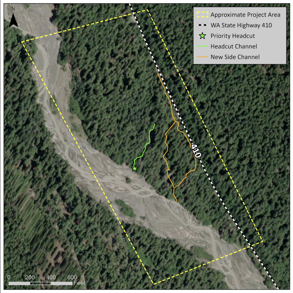
The proposed project area is located near State Route 410 between Mile Post (MP) 58 and MP 60 near the north entrance to Mount Rainier National Park. This section of the highway is adjacent to the White River in a forested area of the park.
Public input is being sought on a plan by the National Park Service and Washington State Transportation Department on a proposed project within the Mount Rainier Wilderness that seeks to reduce the risk of flooding and erosion to a segment of State Route 410 (SR 410) adjacent to the White River in Mount Rainier National Park.
The state agency is proposing to build two log structures in the White River floodplain within the wilderness area adjacent to the road corridor to prevent flooding of the SR 410 road corridor. According to the Park Service, "[F]lood events occurred in 2003, 2005, 2006 and 2016, and resulted in WSDOT installing emergency riprap bank protection in several of these locations to prevent further damage to the highway. Sections of the highway are still in imminent danger of flooding and bank erosion. New side channels formed in the floodplain during spring 2017 that are aimed toward the roadway. Immediate action is needed because additional flood erosion could result in damage or loss to this section of road."
Details of the project area and the proposed action are available on the project website at https://parkplanning.nps.gov/SR410WhiteRiver. Public comments on the project will also be accepted on that site through April 11. There will be a virtual public meeting on March 19 from 4:30 p.m. to 6 p.m. to provide information about the project and answer questions. Links to join the live meeting or watch a later recording will be posted to the project website.

Flooding from the White River has flowed over and eroded away Route 410/NPS file
“Providing sustainable public access to and through Mount Rainier National Park on this highway is a shared management goal for the National Park Service and the Washington State Department of Transportation,” said Mount Rainier Superintendent Greg Dudgeon. “We highly encourage members of the community and park visitors to attend the virtual public meeting and to provide input on this proposed flooding and erosion risk reduction project. Details of the project area and the proposed action are available on the project website and on the project StoryMap."
The Mount Rainier Wilderness was designated as part of the Washington Park Wilderness Act of 1988. The wilderness designation includes 97% of Mount Rainier National Park. Designated wilderness must be managed according to the provisions of the Wilderness Act of 1964.
The proposed flooding and erosion risk reduction project would be located more than 200 feet from the centerline of State Route 410 within designated wilderness.
The proposal includes installations/structures, mechanical transport, and motorized equipment within wilderness. These activities are generally prohibited in wilderness and will be evaluated to determine if the proposed action meets the requirements of the Wilderness Act. Construction access plans are being developed by WSDOT in coordination with the National Park Service. -- NPS
State Route 410 serves as a gateway to Mount Rainier National Park’s east side, providing access to the White River Campground, Sunrise, and popular trailheads. The highway is directly adjacent to and within the floodplain of the White River, which drains the Emmons Glacier. Several locations along SR 410 have been damaged by past flooding and are at increasing risk of future flooding and erosion.
The park anticipates preparing an environmental assessment to analyze impacts of the proposed flooding and risk reduction project. Public comments will help inform and support the park’s decision-making related to the project design and environmental impact analysis.


