Apostle Islands National Lakeshore
Wisconsin’s northernmost edge, consisting of the spectacular mainland sea caves at the tip of the Bayfield Peninsula and the matrix of beautiful and historic islands stretching 25 miles into Lake Superior, was forever protected when Congress established the Apostle Islands National Lakeshore in 1970. Located on the northern tip of Sand Island, the Gothic-style Sand Island Light was constructed in 1881 from sandstone quarried right at the building site.
Remembered today for his unyielding commitment to conservation, U.S. Senator Gaylord Nelson of Wisconsin championed these remote, forested islands becoming part of the National Park System. His hope was to protect their undeveloped shorelines, red sandstone cliffs, windswept beaches, and protected anchorages for public use and from overdevelopment.
The Apostle Islands joined an impressive list of unique and well-loved places set aside, beginning in 1872, for protection, public enjoyment, or scientific interest.

The primary reason the Apostle Islands were set aside was for the purpose of preserving scenery and open space for recreation, with high hopes of economically rejuvenating the area. The park is now recognized for its ecological integrity, its significant maritime history, and its spiritual and subsistence value to the Ojibwe people past, present, and future.
The eight historic Light Stations in the park were actually not added to the preservation mandate until years after the original bill passed, and were not a factor in the creation of the park. Yet today, these iconic lights—along with the sea caves and beaches—are what visitors report they most like about the Apostle Islands National Lakeshore.
It would be overly simplistic to define Apostle Islands National Lakeshore merely through its watery connection to Lake Superior. True, the lakeshore is comprised of 21 islands that dot the lake, but this 69,372-acre mix of water and land also boasts more lighthouses than any unit of the National Park System. There are geologic oddities such as the sea caves that Lake Superior has carved into the shoreline. Plus, this area still retains some of the best examples of a boreal-temperate forest landscape in the Great Lakes region.
And, of course, there is the lake.
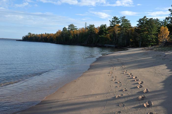
Julian Bay, Apostle Islands National Lakeshore/NPS
Apostle Islands is often overlooked by the rest of the country, but is well known among park travelers from Wisconsin, Michigan, and Minnesota. That changed a great deal this past winter, when enduring cold froze Superior and turned those sea caves into ice caves, dripping with fanciful frozen formations. Media attention from throughout the country and as far away as Australia generated the heaviest tourism the lakeshore has seen, winter or summer.
For those who prefer summer visits, Apostle Islands is a kayaker's paradise. Of the 21 islands (presumably named by early Jesuits who, on early maps, referred to the scattering of islands as 'Isle de 12 Apostles') you may camp on 19 of them. Got two weeks available for paddle-driven exploration? Apostle Islands can accommodate you.
Campers without boats can take scheduled excursions to island campsites. The Stockton Island trip, for instance, offers a chance to hike and camp on the largest island in the park. Walk the beach at Julian Bay here and you'll discover the sand squeaks musically underfoot.
If you prefer to explore on foot, the lakeshore's light towers harken to an earlier day when lightkeepers worked to warn Lake Superior ships away from the islands. Five are open for tours during the high season.

Sunsets can be spectacular at Indiana Dunes National Lakeshore/NPS
Indiana Dunes National Lakeshore
Indiana Dunes is the most popular of the four lakeshores. The park’s high visitation -- nearly 1.7 million in 2016 -- is attributable to its location on the south shore of Lake Michigan near major highways and urban centers. (The park is just 90 minutes from Chicago and 30 minutes from Gary, Indiana.)
Visitors to this nearly 25-mile-long shoreline-hugging park enjoys beaches, sand dunes, bogs, woodlands, prairie remnants, and historical/cultural attractions including an 1830s French Canadian homestead and a working 1900-era farm (both partially restored). A wide array of recreational activities is available, including auto touring, nature walks and hiking, horseback riding, biking, swimming, fishing, camping, picnicking, cross-country skiing, snowshoeing, and wildlife viewing.
Although big sand dunes may be the most visually striking feature of the park, Indiana Dunes is also renowned for its rich variety of plant and animal species. This park has more than 1,400 vascular plant species and ranks seventh among national parks in native plant diversity. Management of this park is made difficult by many factors, including heavy visitation, encroaching industry and related development, air and water pollution, and the fragmented nature of the park landholdings.

Walking the lakefront on Indiana Dunes National Lakeshore in fall melds the landscape to the water setting/NPS
Fall is a nice time to visit Indiana Dunes National Lakeshore. The summer visitors are gone and the trails and beaches are less crowded. After Labor Day, all areas of the park are fee-free, except entrance to the Indiana Dunes State Park, located within the boundary of the national lakeshore. For fall colors, take a walk on the Glenwood Dunes Trail. With side trails and extensions, you can walk anywhere from one to 6.4 miles in a loop.
Horses are allowed on a portion of the Glenwood Dunes Trail—the only horse trail in the park. The elevation is mostly level with gentle rises and dips through the Glenwood Dunes, oldest of three earlier shorelines preserved in the park’s geography.
Another nice fall walk is through the Miller Woods unit of the park. This dune and swale area features tranquil views of ponds (where you might spot a beaver or two) and oak savannah, where deer are common. Start at the Paul H. Douglas Center for Environmental Education where rangers can give you tips on current conditions, bird sightings, and ranger-led activities. Enjoy hands-on family activities at the center, especially the outdoor Nature Play Zone where unstructured play is encouraged.
If the weather is good and the lake is calm, fall is a good time to kayak the Lake Michigan Water Trail—a National Recreation Trail. There are numerous areas to put in and take out your kayak along the park shoreline. A personal flotation device is essential for paddling on the unpredictable lake.
Cycling is increasingly popular in northeast Indiana and new trails and trail sections are constantly opening.
Of special interest – and high public demand – is the annual tour of four historic homes from the 1933 Chicago World’s Fair. This one-day event is held each October. These limited tours are available by reservation only. Each tour lasts two hours and includes an inside look at the Cypress Log Cabin, Florida Tropical, Armco Ferro, and the Wieboldt-Rostone houses.
The original 1933 “Century of Progress” houses featured innovative building materials, modern home appliances, and new construction techniques for their time. The houses were moved to northwest Indiana in 1935 to promote a new housing community and were included in the national lakeshore boundary in the early 1970s. Today, the historic homes are undergoing rehabilitation with private funds through a partnership with Indiana Landmarks and private citizens.
There are hundreds of miles of beaches in the National Park System, but which ones are tops for families? According to Parents Magazine, only one of America's "Ten Best Beaches for Families" is found in an NPS area. The NPS winner back in 2011 was West Beach at Indiana Dunes. The magazine says the area, located only about an hour by car or train from downtown Chicago, offers a number of features that make it ideal for families.
So, what makes a beach "family friendly?"
According to the magazine, the publication's staff "combed through water-quality reports, closings, and advisories for more than 1,000 U.S. beaches" to come up with the 10 best for families. Key factors included ratings of restrooms, calm surf and lifeguards; extras such as nature trails helped narrow the field.
Pictured Rocks National Lakeshore

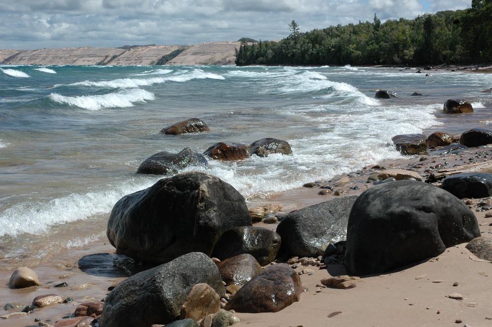
"Battleship Row" at Pictured Rocks National Lakeshore/NPS, Greg Bruff
Pictured Rocks is situated on Lake Superior in Michigan's sparsely-settled Upper Peninsula, where it is renowned for strikingly beautiful sandstone cliffs towering several hundred feet above narrow benches lashed with very cold water.
The first national lakeshore to be created, Pictured Rocks lies along a 42-mile stretch of Lake Superior’s south shoreline in Michigan’s Upper Peninsula. As with the other lakeshores, it does not extend very far inland, just five miles at its maximum width. Pictured Rocks boasts multicolored sandstone cliffs, beaches, sand dunes, woods, waterfalls, inland lakes, and wildlife. While the Lake Superior waters are far too cold and treacherous for comfortable swimming, visitors enjoy a wide range of recreational activities, including sightseeing, hiking, camping, picnicking, hunting, and boating and kayaking along the park’s strikingly scenic cliffs.
This is a four-season park, with winter activities including cross-country skiing, snowshoeing, snowmobiling, ice climbing, and ice fishing. The Miners Castle scenic overlook, which is accessible via a spur road, is a popular choice with motorists. Many park visitors elect to take the 2.5-hour commercial boat tours from the western gateway town of Munising.
Taiga is a word of just two syllables, and yet it connotes remoteness. Its synonym – boreal – is slightly more familiar, though it too conjures the distant, the mysterious. But if you travel to the Great Lakes, to the national lakeshores that line the southern shores of those inland oceans known as Superior and Michigan, you can find yourself deep in the coniferous forests, the taiga or boreal forests, more familiar to the Canadian landscapes to the north.
In fall the remnants of these forests are found at Apostle Islands National Lakeshore in Wisconsin, and Pictured Rocks National Lakeshore a bit farther east in Michigan. The evergreens stand out against the showy, flaring golds, reds, and oranges of the hardwood stands of maples, beeches, and yellow birches, of the northern deciduous forest. To the southeast on Lake Michigan, Indiana Dunes National Lakeshore in Indiana and Sleeping Bear Dunes National Lakeshore in Michigan have another key feature often associated with water: dune systems.
Au Sable Point and Grand Sable Banks/NPS
While lakeshores might inspire dreams of balmy summer vacation spots, the fall months along the country’s northern tier are as enticing and colorful as those in the Appalachians and the Rockies. Yet they’re still mostly undiscovered as fall destinations.
“Fewer visitors means more solitude and almost private beaches and trails. The pace is slower and the sites visited are more thoroughly enjoyed,” says Susan Reece, chief of interpretation for Pictured Rocks. “The temperatures are moderate and there are few insects. With our maple-dominated hardwood forests, the fall colors are spectacular.”
At Pictured Rocks the sandstone cliffs that inspired this lakeshore’s name are rimmed with hardwoods, a contrast to the boreal woods. Frothy waterfalls plunge, some directly into Lake Superior, from these ruddy sandstone walls.

Grand Portal Point, Pictured Rocks National Lakeshore/NPS
Sleeping Bear Dunes National Lakeshore
Sleeping Bear Dunes National Lakeshore consists of fragmented holdings, including North and South ManitouIslands, spread along a 35-mile stretch of Lake Michigan's eastern coastline near Traverse City, Michigan. The park was established to protect outstanding natural and cultural features, including enormous sand dunes that tower as much as 460 feet high, some of the finest beaches on the Great Lakes, forests, inland lakes and wetlands, trout streams, and ancient glacial landforms.
The lakeshore also has outstanding cultural features, including an 1871 lighthouse, three former Life-Saving Service/Coast Guard Stations, a Maritime Museum, the Cannery (historic boat museum), and an extensive rural historic farm district. An excellent road system, including the renowned Pierce Stocking Loop Drive, makes visiting this park very auto-convenient.

The view of Lake Michigan from among the dunes at Sleeping Bear Dunes National Lakeshore/NPS
As might be expected of a place that is world famous for its big dunes, the dune-top lookouts and Dune Climb are very popular. In addition to auto tours, nature walks, and beach activities, the park offers a wide range of outdoor sports such as boating, sailing, kayaking, scuba diving, hunting, fishing, cross-country skiing, and snowshoeing.
And yet, this lakeshore offers a bucolic setting that can sooth your nerves just by looking at it. Farms quilted like patchwork into forests, pocket lakes, and the sweeping miles of Lake Michigan mainland shoreline greet visitors to Sleeping Bear.
This is a sprawling lakeshore, pulled together from nearly 2,000 individual tracts. In autumn, the landscape erupts in color as the beech-maple hardwood forests slowly become cloaked in their fall finery. While there are scenic drives to be enjoyed at Sleeping Bear, this is a lakeshore that begs you to park the car and get out and explore.
“Wilderness” is a relatively new aspect of Sleeping Bear. It was March 2014 when President Barack Obama signed into existence the 32,557-acre Sleeping Bear Dunes Wilderness. Cradling the shoreline on the northern and southern ends of the lakeshore, and surrounding the park’s namesake mother bear and her windswept dunes in the center, the wilderness preserves a place that the Ottawa and Chippewa tribes called home for 3,000 years.
The wilderness area, which also holds the not-quite-100-acre Shell Lake, just might be the most accessible in the National Park System. County Road 22 skirts it, and Route 669 even bisects it, to provide access to the bay and a picnic area.

Fall can be an incredible time to visit Sleeping Bear Dunes National Lakeshore in Michigan/NPS
Other not-to-miss fall sites include Pierce Stocking Scenic Drive, with its iconic covered bridge; the Port Oneida Rural Historic District with its farms, and; the Sleeping Bear Heritage Trail, a multiuse paved trail that runs more than 17 miles from Empire past the lakeshore’s “Dune Climb” and through the village of Glen Arbor to Port Oneida.
Also worth a visit are the wilderness settings of South and North Manitou islands, which Native American legend tells us were created by the Great Spirit Manitou to mark the watery graves of two bear cubs fleeing a forest fire on the Wisconsin side of Lake Michigan. Ferries run from Leland, just north of the park’s mainland setting, to the islands, but only into early October.

Kayaking the Platte River is a popular pastime at Sleeping Bear Dunes National Lakeshore/NPS