
Run, river, run....the Yellowstone River/Kurt Repanshek file
Editor's note: Yellowstone Caldera Chronicles is a weekly column written by scientists and collaborators of the Yellowstone Volcano Observatory. This week's contribution is from Abigail R. McCarthy, Geology Assistant at Yellowstone National Park through the Scientists in Parks program and Stewards Individual Placements, and Blaine McCleskey, research chemist with the U.S. Geological Survey.
Scientists can determine the sources of hydrothermal fluids in park rivers by monitoring water chemistry. The result? A “budget” of which geyser basins release the most hydrothermal fluids.
Visitors to Yellowstone are warned to stay away from hot water in features like geysers and hot springs, but of course the hot water doesn’t stay put in those features—it ultimately flows into the rivers. The water from hydrothermal features contains geothermal chemical components, like chloride, that enter the rivers of Yellowstone National Park. Scientists take water chemistry measurements at sites along the Madison, Firehole, Gibbon, Snake, Gardner, Yellowstone and Falls rivers, as well as Tantalus Creek, to monitor the amounts of these hydrothermal components.
Hydrothermal sources produce most of the chloride (about 94%) found in Yellowstone National Park rivers, so measuring the amount of chloride is a good way to measure the level of hydrothermal activity. At some sites, the amount of chloride detected in river waters at a given time even corresponds with the eruption cycles of nearby geysers. Chloride data available from 1983 onward present a unique dataset for studying changes in geyser activity, as well as the influence of seismicity and the characteristics of the overall hydrothermal system.
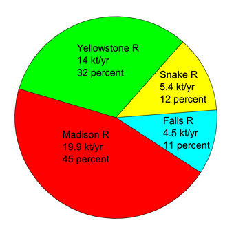
Sources/Usage: Public Domain. Pie diagram showing the chloride flux, in kilotons per year (kt/yr), measured in 2022, with percentages for the four major rivers (Madison, Yellowstone, Snake, and Falls rivers) that drain Yellowstone National Park/Figure developed by Baine McCleskey
Data from just four rivers (the Madison, Yellowstone, Snake, and Falls rivers) are used to determine the overall amount of hydrothermal activity the park. Water flowing through these four rivers brings hydrothermal solutes and heat with it on its way out of the park. In this way, it is possible to determine a hydrothermal budget for Yellowstone, and to identify which rivers are carrying the most hydrothermal waters and how the amounts change over time.
So, which area of Yellowstone National Park do you think has the strongest component of hydrothermal input? Hint: consider where the most famous geyser in the park is located... That’s right, it’s the Madison River! The monitoring station on that river, near West Yellowstone, Montana, measures the park’s largest chloride source, at 45 percent of the park’s total. That number includes hydrothermal input from the Upper, Midway, and Lower geyser basins. Many of the park’s most popular features, such as Old Faithful and Grand Prismatic Spring, are in these basins. Chloride flux from the other rivers is less, with the Yellowstone River in second place (32 percent), followed by the Snake (12 percent) and Falls (11 percent) rivers.
In addition to this overall measure of river chemistry, it is also possible to see the inputs of specific geyser areas to an individual river. This is done by studying measurements from multiple points along the same river. For example, let’s take a trip north along the Yellowstone River from Yellowstone Lake to Gardiner, Montana, and measure the water chemistry along the way. Fans of the West Thumb Geyser basin trail have witnessed features like Fishing Cone and Lakeshore Geyser spew hot water directly into the lake, and there are numerous hydrothermal vents on the lake floor. Thirty-four percent of the chloride in the Yellowstone River comes from the Yellowstone Lake area, which accounts for 11 percent of the park’s overall chloride flux.
The Yellowstone River then passes through Hayden Valley (please don’t pet the bison!), where 29 percent of the chloride in the river is picked up, sourced from features like Mud Volcano and Crater Hills. We’ll enjoy the inspirational views from Inspiration Point at the Grand Canyon of the Yellowstone on our way to Tower Junction. This reach of the river accounts for 14 percent of the chloride, sourced from features like Calcite Springs and Joseph’s Coat Hot Springs. Along the Tower-Gardner reach, there is very little chloride input, because there are few thermal areas in this region of the park.
The Gardner River empties into the Yellowstone River near Gardiner, Montna, at the northern park boundary. Here, 22 percent of the Yellowstone River’s chloride enters. Much of this hydrothermal input comes from Mammoth Hot Springs and Boiling River, which releases 6 percent of all the chloride that comes from the park!
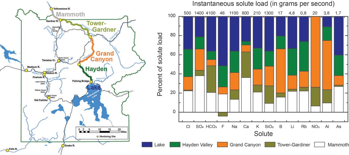
The Yellowstone River is divided into five reaches (labeled and color-coded): Yellowstone Lake, Hayden Valley, Grand Canyon of the Yellowstone, Tower–Gardner, and Mammoth. Monitoring stations (yellow dots on map) between each reach of the river reaches allow geochemists to measure river composition and then determine the sources of chloride (Cl) and other solutes from hydrothermal features/Figure developed by Baine McCleskey.
Water chemistry monitoring continues at this very moment, providing a tool for us to learn more about Yellowstone’s incredible hydrothermal activity.


