NPS Maps
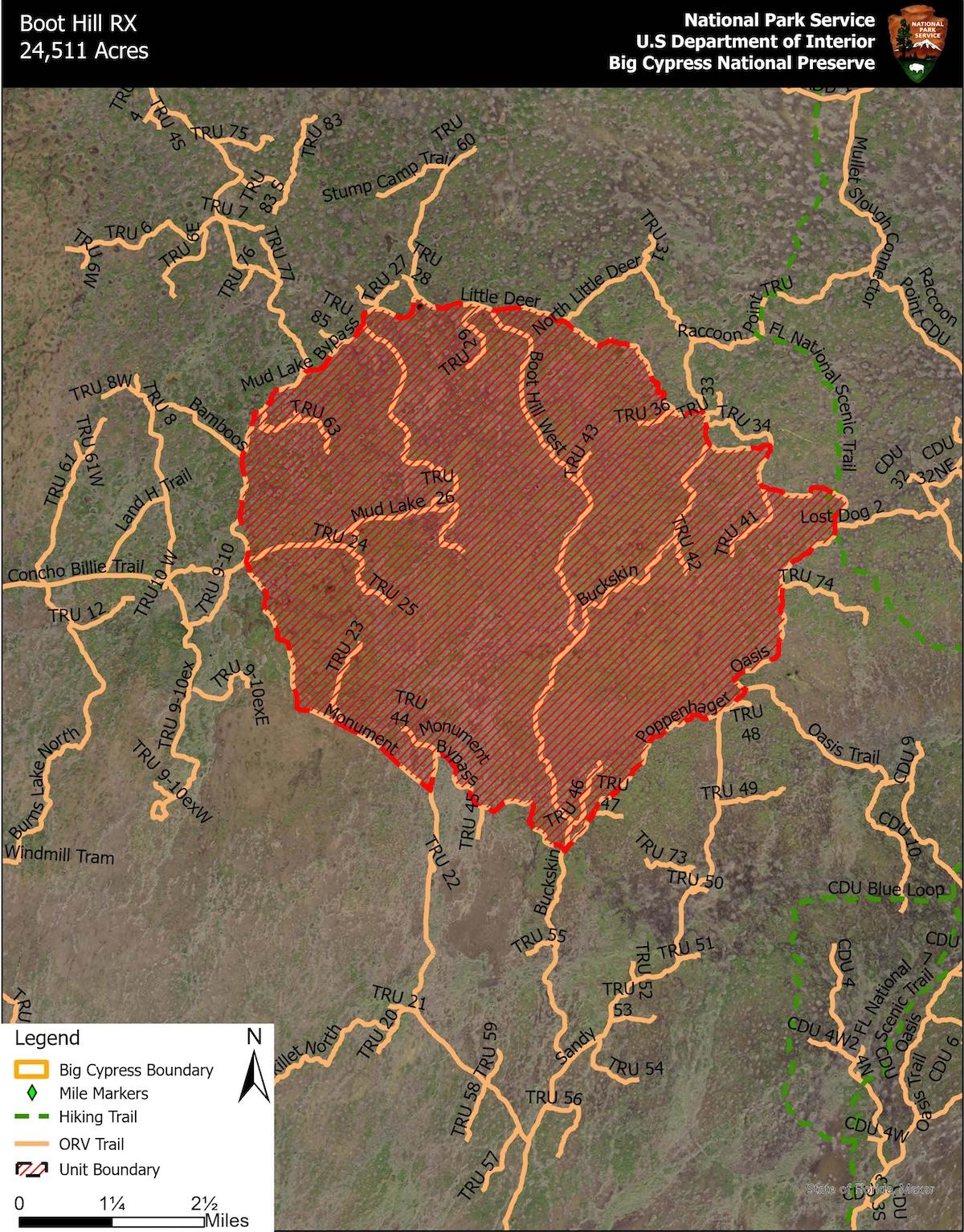
Due to prescribed fire activity beginning Wednesday, January 8, 2025, Big Cypress National Preserve in Florida has issued a temporary trail closure to promote visitor safety.
Closure includes all areas and trails within the treatment perimeter, trails on the perimeter of the unit will remain open for use. During the closure all recreational use including off-road vehicles, hiking, camping, hunting and commercial activities are prohibited in the designated areas.
Prescribed fire is a carefully planned fire that uses fire science and specific environmental conditions to meet management goals for the preserve. A prescribed fire is one of Big Cypress’s best tools to help create a mosaic of diverse habitats, manage for our endangered species, and reduce the threat of a destructive wildfire.
Please refer to the provided map and area description below, temporary closures include the following areas:
- All areas within the perimeter of the unit
- TRU 63
- TRU 26
- TRU 29
- TRU 43
- TRU 36
- TRU 41
- TRU 42
- TRU 46
- TRU 44
- TRU 23
- TRU 24
- TRU 25
- Portions of Buckskin *see map.
- Boot Hill West *see map.
- Portion of Mud Lake *see map.
- Portion of FL National Scenic Trail - approx. 0.5-mile section including 13-Mile Camp *see map. Hikers may utilize Oasis Trail as an alternate route, leaving the FL trail just south of 13-Mile Camp and reconnecting with the FL trail just north of 13-Mile Camp.
The following adjacent areas will remain open:
- Private lands in the designated area; residents should use caution and notify the Fire Duty Officer of entry by calling 561-923-5228.
Fire personnel anticipate 3-5 days of ignition operations and typically determine an area safe for reentry 2-4 days after ignitions are completed. Big Cypress Fire and Aviation will make a determination after ignitions are complete on when to lift the closure. The public will be advised of the implementation and subsequent termination of this closure by web alert, and by the posting of signs in the appropriate areas. If a longer closure is required, due to additional fire activity, an additional press release will be issued immediately.


 Support Essential Coverage of Essential Places


