You can fly into either Grand Junction or Montrose, Colorado, then rent a vehicle for the remainder of the trip into Black Canyon of the Gunnison National Park. The park is about an hour’s drive from Grand Junction, and about 20 minutes from Montrose. There is no public transportation into the park, but there is bus service available from Grand Junction, Montrose, and Gunnison.
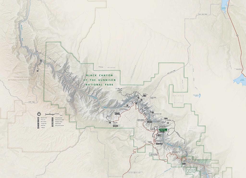
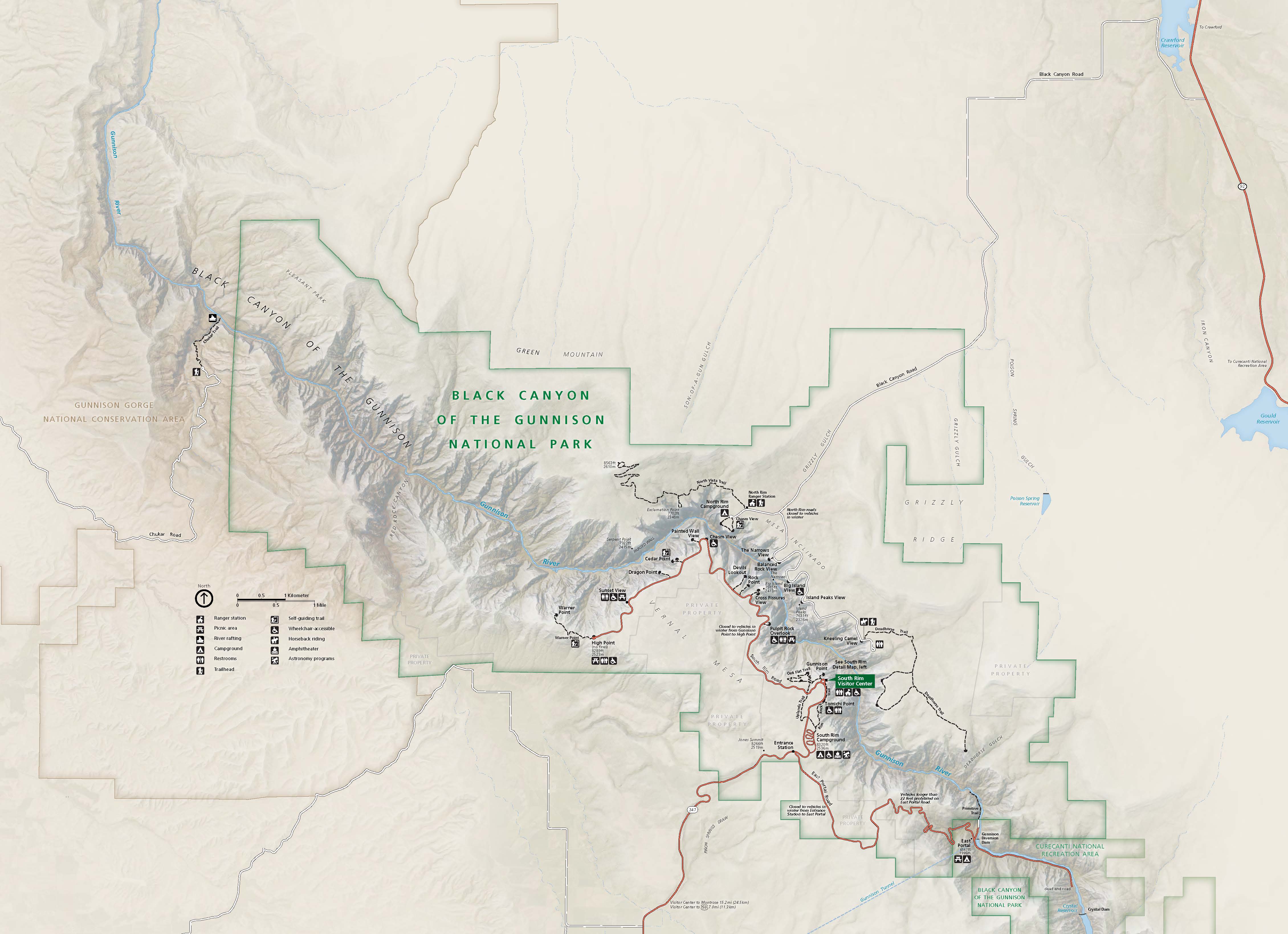
Black Canyon of the Gunnison National Park map / USGS file
For a park map, click here.
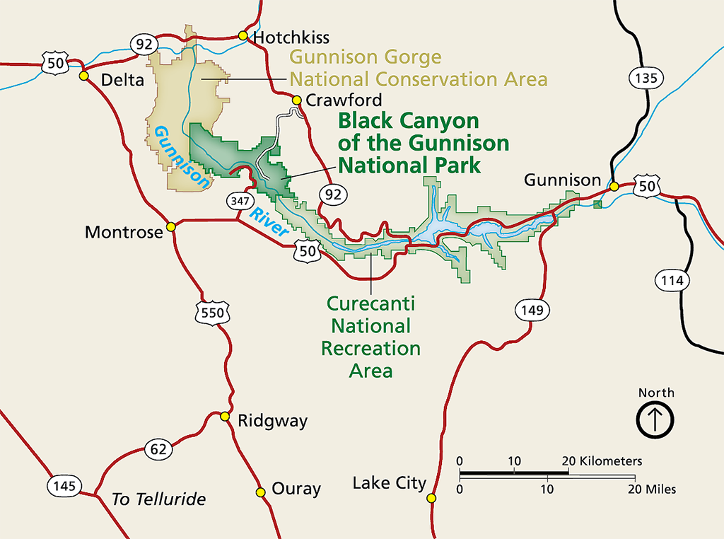
Regional map around Black Canyon of the Gunnison National Park / NPS file
Distances here are measured from the South Rim Visitor Center:
- 14 miles (22.5 km) northeast of Montrose, Colorado
- 63 miles (101 km) northwest of Gunnison, Colorado
- 75 miles (121 km) southeast of Grand Junction, Colorado
- 264 miles (425 km) southwest of Denver, Colorado
Getting to the South Rim
The South Rim is 7 miles (11.3 km) north on CO Highway 347 from the intersection with U.S. Highway 50 east of Montrose. The physical/GPS address is - 9800 Hwy 347, Montrose.
There is no bridge across the canyon. Allow 2 to 3 hours to drive from one rim to the other.
Getting to the North Rim
The North Rim is 11 miles (17.7 km) southwest of Crawford. From CO Highway 92, turn west on Black Canyon Road approximately 3 miles (4.83 km) south of Crawford. The physical/GPS address is 7295 Black Canyon Road, Crawford. Follow the road signs to the park. The last 7 miles (11.3 km) are unpaved. The North Rim is closed to vehicles in the winter.
There is no bridge across the canyon. Allow 2 to 3 hours to drive from one rim to the other. The North Rim is closed to vehicles in the winter.
Distances (from South Rim)
Location/Nearby Park | Distance (miles) | Distance (kilometers) |
Montrose, CO | 14 miles | 22.5 km |
Gunnison, CO | 63 miles | 101 km |
Grand Junction, CO | 75 miles | 121 km |
Denver, CO | 264 miles | 425 km |
Curecanti National Recreation Area - Blue Mesa Reservoir (CO) | 36 miles | 58 km |
312 miles | 502 km | |
156 miles | 251 km | |
199 miles | 320 km | |
90 miles | 145 km | |
Dinosaur National Monument (CO/UT) | 207 miles | 333 km |
200 miles | 322 km | |
294 miles | 473 km | |
352 miles | 566 km |
There is no gas station or EV charging station within the park. The closest places to refuel are in Grand Junction, Delta, Montrose, Gunnison, and Crested Butte, Colorado. According to Plugshare.com, there are 159 charging locations, including the previously-listed towns and other locations along U.S. Route 50 and Colorado State Highways 65, 92, and 135.


