Proposals for renewable energy projects can pose a challenge for environmental organizations'they may like the "green" aspects of solar and wind power, but in the wrong location such projects can have big impacts on values such as scenery and wildlife. In that regard, the Soda Mountain Solar Project near the Mojave National Preserve can claim one distinction: it has united opposition by numerous local, regional and national groups...and the National Park Service.
Now the question is whether the developer will succeed in defeating years of good planning to determine the best sites for major solar projects.
A casual glance at the Southern California location between Baker and Barstow might suggest the site seems a logical choice for a major solar power plant'it's located along both sides of an interstate highway and two existing power lines run through the area. Opponents of the project, however, say "Not so fast," and point out that a closer look will reveal a number of issues with this site.
One such group, the National Parks Conservation Association, sums up a key objection:
"The Soda Mountain Solar Project is a proposed industrial scale renewable energy development that would be constructed less than one mile from the boundary of Mojave National Preserve, the third largest national park unit in the lower 48 states. It would be one of the closest, if not the closest, renewable energy projects to a national park unit in the entire southwestern United States."
Also nearby is the Soda Mountains Wilderness Study Area, which is managed by the U.S. Bureau of Land Management (BLM)'a fact that seems conveniently ignored on most of BLM's maps and discussion of the solar project.
"Industrial Scale" Energy Development
To understand the issues, it's helpful to have some idea what is meant by the term "industrial scale" energy development. In this case, the project would use about 4,100 acres of public land; of that total, about 2,200 acres would house some 1.7 million flat-plate solar panels, grouped into tracking arrays.
That's a big project by almost anyone's standards, and the BLM has generated plenty of paperwork on the proposal. Just one of two volumes of the agency's Draft Plan Amendment/Environmental Impact Statement/ Environmental Impact Report (DEIS) runs to 760 pages, and if you'd like to download the full DEIS, you'd better have a fast Internet connection: the files total 93 Mb.
Is the DEIS Long on Word Count and Short on Substance?
With that many words put to paper (or disk), one might expect a thorough analysis of the issues, but opponents of the project say that's unfortunately not the case.
For starters, impacts on scarce local water resources by any desert development deserve careful study, but that's only one of a number of issues raised in a letter to the BLM from the National Park Service.
The project's developer, Bechtel Development Company, reportedly plans to pump up to 60 acre-feet of groundwater from the project site each year, and there are questions about what effect that will have on springs that are vital to wildlife, including an endangered species of fish. According to the NPCA, the nearby park includes "240 naturally occurring seeps and springs that provide sustenance for a wide variety of desert wildlife species."
"Little is Known" About the Groundwater Basins

The aptly named Dry Lake, inside the park near the proposed solar project, illustrates the scarcity of water in the area. NPS photo.
How does the BLM address these concerns in DEIS? It says, "Much of this hydrologic region is public land with very low population density. Within these areas, there has been little groundwater development and little is known about the basins."
The agency's conclusion: Even though it's not known if there's any connection between nearby aquifers, "no impact [from the project] would occur" on the spring that's home to the rare and endangered fish, or other wildlife that depends upon those springs.
In its letter to the BLM, the NPS "disagrees with the ...analysis that concludes a lack of impact because sufficient information is not available. Without conclusive knowledge about the hydrology of the Soda Mountain Valley aquifer, the Project risks the consequence of irreversible damage to the habitat and the viability of this highly endangered species."
While some people may shrug off the value of a rare and endangered fish population, similar concerns affecting desert bighorn sheep have drawn more attention.
Potential Impacts to Seeps and Springs Not Considered
The project site is about a mile from the point where the ZZyzx Road enters the park and continues on the Desert Studies Center, a field station of the California State University. ZZyzx (pronounced Zye-Zix) was historically known as Soda Springs, and the area's natural and manmade ponds and intermittent lakes are invaluable to wildlife. The NPS letter points out that, inexplicably, "The DEIS does not consider potential impacts to small seeps and springs along ZZyzx Road on the north end of the Soda Mountains. These surface features are frequently and heavily used by desert bighorn sheep; if drawdown from the groundwater table adversely impacts these features, desert bighorn sheep will also be negatively affected."

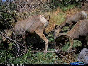
This image of desert bighorn drinking from a natural spring in the park was captured by an automated camera. NPS photo.
Questions about the project's potential impact on the park's population of desert bighorn sheep extend beyond the animals' water supplies. The health and perhaps the long-term survival of that population could depend upon the animals' ability to use migration routes through the proposed solar site. According to the NPS, "If the project moves forward as described... , bighorn sheep migration between the north and south areas of the project will likely be permanently impeded."
Other Concerns
Any other concerns? There are plenty, including impacts on other wildlife species and on the area's night skies and scenic viewsheds, values which are also recognized by local government officials.
San Bernardino County has a Renewable Energy Ordinance that requires, 'For proposed facilities within two (2) miles of the Mojave National Preserve boundaries, the location, design, and operation of the proposed commercial solar energy facility will not be a predominant visual feature of, nor substantially impair, views from hiking and backcountry camping area with the National Preserve.' One has to wonder if such local guidelines have been considered as part of the project analysis.
NPS Boundaries Missing from Project Maps
Have the BLM and Bechtel given enough consideration to the proximity of the site to NPS lands, and the BLM's own Soda Mountains Wilderness Study Area?
It's a fair question, based on public meetings the agency held in January in Barstow and Yucca Valley, California. According to individuals who attended those events, maps posted at the meetings describing the project did not even show the boundary of the nearby national preserve or existing and potential wilderness areas. Other maps posted on the BLM website about the project include the disclaimer, "The Bureau of Land Management makes no representation regarding the accuracy or completeness of this map."
Is there a bit of a double standard at work in the current project in terms of considering resources on NPS lands? The NPS letter to the BLM notes that the DEIS rejected an alternative site for the solar project on private land, based in part on that site's proximity to the Mojave River wildlife linkage corridor, critical habitat for desert tortoise and an area of Critical Environment Concern that is managed by the BLM.
The NPS points out that very similar constraints exist on the Soda Mountain site, and asks the "BLM to analyze the Soda Mountain location with the same level of prudence and scrutiny that was given to the private lands alternative."

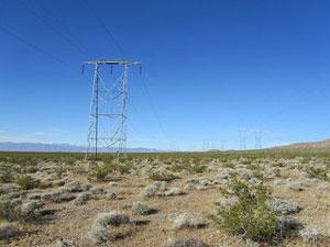
Are existing transmission lines actually available to move power from the Soda Mountain site to distant markets? Photo by SkinheadSportBiker1 via Flickr.
Should Power Line Access Trump Resource Concerns?
Some will discount questions about natural resources and other park values, pointing to the project site's proximity to an existing utility corridor as a compelling reason to select this location. That argument conveniently overlooks the fact that the existing power lines run for many a mile beyond the currently proposed site, and a closer look raises some interesting questions about the area's highly touted advantage of those lines.
According to media reports, one of the two existing power lines is already carrying the maximum load possible, and it's not clear if there is enough capacity in the second line to move the power generated by the project to market. If costly new transmission lines had to be built, who would pay those costs? Ultimately, consumers or taxpayers, so a power-producing site closer to markets for the power would certainly make much more sense.
Perhaps even more surprising are reports that the project developer has been unable thus far to secure an agreement with any utility company to buy the power that would be generated at the site. Perhaps Bechtel has a secret deal tucked away, or believes that California requirements to increase the amount of power generated by renewable sources by 2020 will eventually make this an "If you build it they will buy it," situation. In the absence of either a demonstrated means to get the power to market'or a utility willing to buy the electricity produced'one has to wonder, however, if Soda Mountain could be the solar power equivalent of the oft-derided "bridge to nowhere."
A Persistent Developer
Given all of the issues raised, why is the developer forging ahead?
At least part of the answer may lie in a strategy to dodge comprehensive planning efforts, including the "Solar Energy Development Programmatic EIS (Solar PEIS). This was a major, multi-agency planning effort that began in 2008 and required four years to complete. Its purpose was to identify the best sites in six Western states for "utility-scale solar energy development" and "ensure consistent application of measures to avoid, minimize, or mitigate the adverse impacts of such development."
Sounds like a good idea, and the announcement of the final approval for the Solar PEIS in October 2012 included some lofty expectations:
'The Solar PEIS sets forth an enduring, flexible blueprint for developing utility-scale solar projects in the right way, and in the right places, on our public lands,' said David J. Hayes, deputy secretary of the Interior. 'Never before has the Interior Department worked so closely and collaboratively with the industry, conservationists and sportsmen alike to develop a sound, long-term plan for generating domestic energy from our nation's sun-drenched public lands.'
Did a Massive Planning Effort Fail?
In short, that massive planning effort was intended to avoid locating solar projects on sites with the kinds of issues raised about the Soda Mountain Solar Project. Does that mean the Solar PEIS fail to meet those goals?
No, because for an astute developer, timing trumps good planning.
The original application for the Soda Mountain Solar Project was filed with the BLM by New York-based Caithness Corporation before the Solar PEIS process got underway. After encountering a number of conflicts with resource-based issues, Caithness pulled back from the project, but later sold its interests, including the still-pending permit application and various environmental studies, to the Bechtel Development Company.
As a result, the now revived application for the Soda Mountain site is "grandfathered," and thus exempt from the provisions of the Solar PEIs'but that's not the developer's only reason to forge ahead.

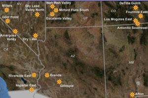
The Solar PEIS identified suitable sites for large-scale solar projects. For a larger version, click here.
Beating the System, Twice Over
A second, and even more comprehensive, planning effort called The Desert Renewable Energy Conservation Plan (DRECP) is currently underway for the desert regions and adjacent lands of seven California counties. It is being prepared through "an unprecedented collaborative effort between the California Energy Commission, California Department of Fish and Wildlife, the U.S. Bureau of Land Management, and the U.S. Fish and Wildlife Service also known as the Renewable Energy Action Team."
The DRECP has been described as a "fine-tuning" of the Solar PEIS, and is intended to "provide effective protection and conservation of desert ecosystems while allowing for the appropriate development of renewable energy projects."
"Trying to Get It Right"
David Lamfrom of the NPCA compared the older Solar PEIS to a view of the area taken from 30,000 feet, while the newer DRECP is a akin to a picture taken at ground level. "We're trying to get it right in terms of planning for the California desert, and Soda Mountain is not part of that planning process," he said.
As is the case for the earlier Solar PEIS, Bechtel can also avoid any guidelines developed by DRECP by pushing ahead with the already filed application for the Soda Mountain Solar Project. If the BLM eventually approves the project, it will be a double win for the developer...and a loss for good planning and the affected resources.
Are There Better Locations for This Project?
Many people do support the idea of renewable energy sources, so perhaps a key question is whether there are better places for this project.
The NPS thinks so, stating, "...We urge the BLM to reconsider the potential for this project to be sited on other BLM lands, private lands, or other degraded lands where renewable energy projects would present fewer adverse impacts to natural and cultural resources."
Others, including the NPCA agree, pointing out, "At last count, the California desert has over one million acres of disturbed lands or previously developed lands that may be more appropriate for solar panels and associated development."
Will this project eventually be built in the currently proposed location, or might it find a new home that offers fewer conflicts? That remains to be seen. The public comment period for the BLM's DEIS ended earlier this month, so that agency will now move ahead with whatever evaluation it deems appropriate for that public input.
A lot of people will be interested in the outcome.


 Support Essential Coverage of Essential Places


Comments
What is the reason for all that water? 60 acre-feet is a lot of water in a dry land. Is it for cooling or what?
It's mainly for regular washing of desert dust off all those solar panels.
Maybe they could just buy a bunch of SWIFFERS.
Don't they come with their own windshield wipers?
The technology exists to keep solar panels clean without using water, here are some examples:
http://www.bu.edu/today/2014/self-cleaning-system-boosts-efficiency-of-s...
http://www.iom3.org/news/self-cleaning-solar-panels-ditching-dirt-self-c...
http://www.multivu.com/mnr/64194-sunpower-announces-acquisition-of-green...
https://www.youtube.com/watch?v=gfNxrJQXfYY
http://www.solarbrush.co
Fascinating.
Thank you, Industrial, for sharing those links.
Dittos Lee, thank you Industrial. Lee, on another subject, please excuse, the tragic loss of the Malaysian airliner has led to a great deal of coverage of the large masses of garbage floating around in the oceans. Very interesting, some say the floats combined would equal the size of Texas. That material floating on top is plastic, primarily water bottles, cups, bags, caps, etc. It is becoming a very serious environmental issue. Many thanks to those Park Managers that are banning the sale of said in the National Parks.
Yes, Ron, but I'm sure there are some who will argue that the floating debris has only an "insignificant" effect because the oceans are so big.