It may be difficult to fathom as you stand on the rim of this 5 x 6-mile (8 x 10 km) basin filled with impossibly blue water 1,943 feet (592 m) deep, but a 12,000 ft-tall (3,657.6 m) volcano known as Mount Mazama once stood where this basin is set. A cataclysmic explosion some 7,700 years ago, caused this volcano to collapse in upon itself, forming a caldera (a bowl-shaped depression) eventually filling with water.

An early morning view of Wizard Island, Crater Lake National Park / Rebecca Latson
Mount Mazama was a composite volcano – a very large, tall volcano composed of lava flows, pyroclastic deposits (volcanic fragments of pumice and ash), and mudflow deposits. Situated within the Cascade Range – a chain of volcanoes running over 700 miles (1,126.5 km) from northern California to British Columbia in Canada – Mount Mazama, although collapsed, is still considered active and is expected to erupt beneath the water’s surface sometime in the future.
During Mount Mazama’s climactic eruption 7,700 years ago, but before it collapsed into a caldera, a huge column of ash reached skyward at the same time super-heated avalanches of pumice (a very porous volcanic glass light enough to float on water) and ash rushed down the volcano’s slopes.

Map showing distribution of pumice deposits from Mount Mazama's eruption, Crater Lake National Park / Wikimedia Commons
Mazama’s eruption occurred, according to the Oregon Explorer:
… in at most a few days. The volcanic ash covered parts of the northwestern states to as far as central Canada. Rare particles of Mazama ash have even been found in ancient ice from Greenland. The airfall pumice and ash covered a total surface area of more than 1,000,000 mi2 (2,600,000 km2) at least 1 mm thick, and no less than 5,000 mi2 (13,000 km2) more than 6 inches (15 cm) thick. A volume of 10-13 mi3 (42-54 km3) of the mountaintop had disappeared.
The super-heated avalanche pumice and ash flowed at high speed to distances between 4 miles (6.4 km) and 35 miles (56.3 km) away from Mazama’s flanks. The combination of airfall and avalanches resulted in thick deposits of pumice and ash burying a nearby valley over 100 feet (30 m) deep to create Pumice Desert, a landscape over which you drive after passing through the park’s Northern Entrance.

Driving across Pumice Desert, Crater Lake National Park / Rebecca Latson
Stop at any of the view areas along the northwest portion of the lake’s Rim Drive and look across the road to the distant landscape. You’ll get an almost bird’s-eye view of Pumice Desert and the park road running over it.

Looking across Rim Road at the vast expanse of Pumice Desert, Crater Lake National Park / Rebecca Latson
After Mount Mazama’s collapse, lava continued to flow on the caldera floor through five different vents, creating smaller volcanoes within the caldera. At the same time, the caldera was filling with water from streams and melting glaciers, ultimately reaching such a depth that only Wizard Island managed to break the surface of what we now call Crater Lake. Today, no river or stream flows into the lake to muddy up its clarity and deep blue color. Snow and rainfall balance the ongoing evaporation and seepage of lake water.

Drawing of sequence of events in the creation of Crater Lake / NPS
What would happen if Mount Mazama awoke from its slumber to erupt beneath Crater Lake?
According to the United States Geological Survey (USGS):
Water tends to play a big role in the explosivity of an eruption. The interaction between water and magma could produce highly explosive hydrothermal eruptions that send rock fragments and large blocks out of the caldera. Factors that determine how violently water and magma interact include the type of magma, its rate of extrusion, how much gas is in the magma, and the depth of the water in which it erupts. Shallow water eruptions may be highly explosive, while those in the deep lake are expected to be much less violent. More recent monitoring data shows that most of the post-caldera volcanic activity has been concentrated on the western half of the caldera, and indication that future activity will likely occur within that area. There is the possibility of the formation of a new vent on the flanks of Mount Mazama or the surrounding area. There is a north–south trending active fault zone traversing the west half of Crater Lake National Park, which could cause damaging earthquakes.
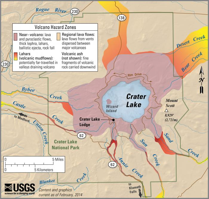
Simplified hazards map showing potential impact area for ground-based hazards during an eruption event, Crater Lake National Park / USGS
For a more in-depth description of Crater Lake’s geology, you can download a PDF version of the park’s Geologic Resources Inventory Report.


