Denali Mountain is not called “The Tall One” for nothing, standing at 20,310 ft (6,190.5 m)! It’s the tallest mountain in North America, and is actually taller than Mount Everest! It’s a full mile taller!

Denali Mountain wreathed in clouds, Denali National Park and Preserve / Rebecca Latson
According to the United States Geological Survey (USGS):
A mountains’ height is measured from base to summit. Denali measures around 18,000 ft from base to summit, while Mount Everest is around 5,000 ft [1,524 m] less. This is possible because Mount Everest is the highest mountain on earth, but not the tallest. While Denali is technically taller, the base starts out at a lower elevation than Everest, reducing the overall height it can reach. Specifically, Denali’s base is located a mere 2,000 ft [609.6 m] above sea level while Everest's base begins at 14,000 ft [4,267 m] above sea level. So, while Everest reaches the highest point in the atmosphere, the distance from base to peak of Denali constitutes a greater vertical rise.
Alaska is in one of the most geologically active regions of the country. Volcanoes, glaciers, and plate tectonics all have a hand at shaping and sculpting the Denali National Park and Preserve landscape. The height of Denali Mountain is due to the active geologic process of plate tectonics.
Think of the land as sheets or plates floating on a partially-molten sea (the earth’s mantle). As these plates are carried along by the mantle’s molten currents, they crash into each other. Sometimes they crash, then pull apart, and at other times, they crumple into and on top of one another. In the case of Denali, the Pacific Plate and the Yakutat microplate collided with the North America Plate and caused a period of uplift and mountain building as these plates crumpled like a piece of paper. This process all began about 66 million years ago, during what is called the Cenozoic era.
To help with this uplift is the aptly-named Denali fault, a very long, active crack in the earth spanning most of Alaska’s width and running about 746 miles (1,200 km) from the Yukon border to the Bering Sea. This active fault causes displacement of rocks, and in the area of Denali Mountain, these rocks have stacked up to increase the height of the mountain.

The Denali Fault offsetting crevasses on the Canwell Glacier, Denali National Park and Preserve / USGS - Peter Haeussler
Denali, itself, is composed of igneous and metamorphic rocks. Igneous rocks are volcanic in origin, and metamorphic rocks are rocks that have been altered from their original form by heat and immense pressure.
The landscape of this national park and preserve has been shaped by glaciers and meltwater. Glaciers carve and scrape and scoure the mountains and terrain, carrying tons of rock and soil from one spot to other locations miles away. Meltwater also carries rock and soil, depositing it elsewhere. These active processes continue carving, scraping, and scouring existing landforms in one location and deposit the load in other places. According to the National Park Service, glaciers “etch and fill up 16 percent of the park.” So if you want to see glaciers and their resulting landforms (aretes, cirques, erratics, tarns), this national park and preserve is the place to go.

Glaciers are literally "rivers of ice" and can carry debris hundreds of miles from their origin, Denali National Park and Preserve / Rebecca Latson
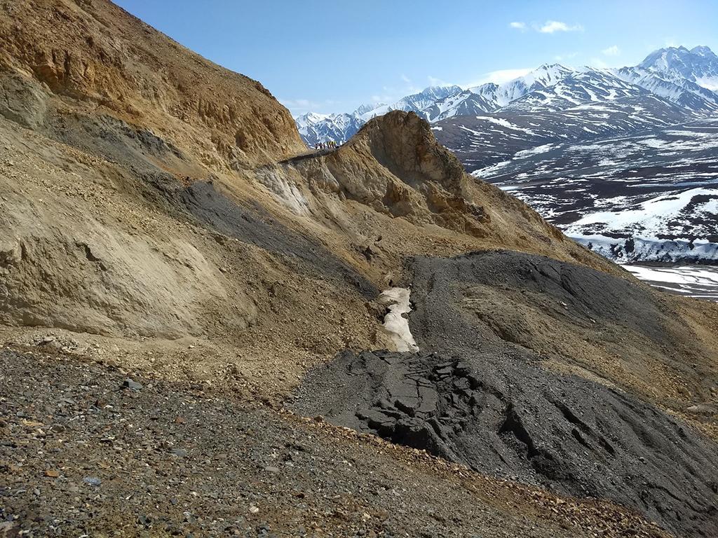
Other geologic processes, such as landslides (the movement of a mass of rock, debris, or earth down a slope), have also had a hand in shaping this landscape, sometimes creating “geohazards,” which are geologically-induced road or other hazards to the human population. The Pretty Rocks Landslide is one such geohazard.

Contractors visiting the Pretty Rocks Landslide site in spring 2023, Denali National Park and Preserve / NPS file
According to park staff:
The Pretty Rocks landslide has been active since at least the 1960s, and probably since well before the Denali Park Road was built through this area in 1930. Before 2014, the landslide only caused small cracks in the road surface and required moderate maintenance every 2–3 years. However, in 2014, road maintenance crews noticed a substantial speed up. By 2016 the movement had increased further, a slump had developed in the road, and a monitoring program was begun. The rate of road movement within the landslide evolved from inches per year prior to 2014, to inches per month in 2017, inches per week in 2018, inches per day in 2019, and up to 0.65 inches per hour in 2021.
The Polychrome Area Plan will construct a bridge over the slide area with a projected finish date sometime in 2026.
By now, you’ll notice almost all the textbook geologic processes have helped create Alaska, Denali, and the landscape within this national park and preserve (volcanoes, glaciers, plate tectonics, landslides). What else is missing? How about earthquakes.
According to park staff:
Because of active plate tectonics, earthquakes are frequent in the Denali area. It is estimated that there are some 600 seismic events per year within the park boundaries at magnitude 1 (M1) or greater. Most of these earthquakes (about 70%), average between M1.5 and M2.5, and often occur near the surface (0-15 km/0-9 miles deep) at locations all over the Park. But these events are not usually felt by anyone because of the low magnitudes. A large share of earthquake activity is right under Denali, frequently, at very deep locations (90 – 125 km/54-75 miles deep), providing few people the opportunity to experience them. This seismic activity at the root of Denali suggests that uplift of the mountain continues to this day. Numerous faults, including the Denali fault (a major fault system), demonstrate a long history of active plate tectonics and associated earthquake activity.
To read more detailed information about Denali National Park and Preserve geology, click here, and here.


