While an epic road trip is one way to get to Everglades National Park in southern Florida, more than likely, you will be flying (then driving). Luckily, there are three major airports in the southern Florida area into which you can fly (then drive) to reach Everglades National Park.
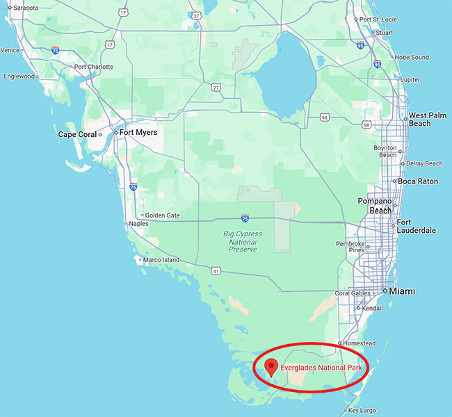
Area map around Everglades National Park in southern Florida / Google Maps Screenshot
Of those three, Miami International Airport (MIA) is the closest with a driving distance of less than 36 miles (57.9 kilometers). It’s a 74.6-mile (120-kilometer) drive from Southwest Florida International Airport (RSW) near Fort Myers, and a 61-to-68-mile (98.2-to-109.4- kilometer) drive from Fort Lauderdale-Hollywood International Airport (FLL), depending upon whether or not you choose the Florida Turnpike toll road.
As for the driving part, once you’ve arrived in Florida, there are three different park entrances, none of which are interconnected. To access the park via any of these entrances, you will need a vehicle since driving distances are lengthy, and the only public transportation is via the Homestead Tolley to the National Parks, which ferries visitors to the Ernest F. Coe Visitor Center and Royal Palm but nowhere else in the park.
There are also two sections to Everglades National Park: a northern section and a southern section. The Homestead Entrance is the main entrance to the park and is within the southern section. The Miami and Everglades City entrances access the park’s northern section. The Miami Entrance is on the northeast side of the park while the Everglades City Entrance is on the northwest side, 36.5 miles (58.7 miles) away from the city of Naples, Florida.

Map of Everglades National Park with the three park entrances highlighted / NPS graphic
According to park staff:
Homestead Entrance
Ernest F. Coe Visitor Center, Everglades National Park / NPS file
This is the main entrance for Everglades National Park. The Ernest F. Coe Visitor Center is located at this entrance, as well as access to Royal Palm and Flamingo.
Take the Florida Turnpike (Route 821) south until it ends, merging with U.S. 1 at Florida City. Turn right at the first traffic light onto Palm Drive (State Road 9336/SW 344 St.) and follow the signs to the park.
Public transportation to and from the Ernest F. Coe Visitor Center and Royal Palm is seasonally available through the City of Homestead trolley service, from approximately December through April. This is the only public transportation offered to anywhere inside of the park. Schedules are subject to change.
Schedules and reservations can be found at the City of Homestead website: Homestead Trolley to the National Parks.Miami Entrance
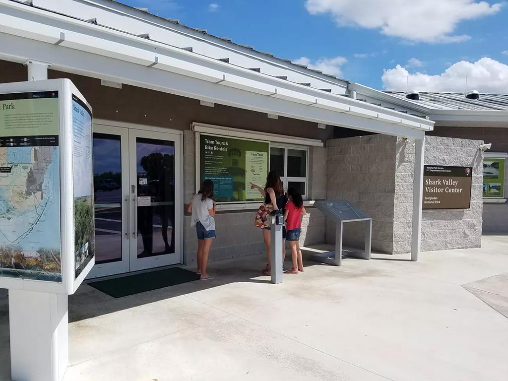
Shark Valley Visitor Center, Everglades National Park / NPS file
The Shark Valley Visitor Center is the entrance closest to the Greater Miami Area, Florida.
Directions To Shark Valley Visitor Center From Miami:
From the Florida Turnpike, get off on exit 25A (from the north) or exit 25 (from the south) take U.S. 41 (Tamiami Trail / SW 8th St.) 25 miles (40.2 kilometers) west to Shark Valley.
Directions To Shark Valley Visitor Center From Naples:
Take U.S. 41 (Tamiami Trail / SW 8th St.) approximately 70 miles (112.7 kilometers) east to Shark Valley.
Everglades City Entrance
Temporary visitor center for the Everglades City Entrance, Everglades National Park / Everglades Adventures Photo
The Everglades City entrance is the entrance closest to Naples, Florida. The Gulf Coast Visitor Center is currently closed for construction, but the Ten Thousand Islands area of the park remains accessible by boat. Visitor Services are temporarily located at the Everglades Adventures Visitor Center in Everglades City.
Directions to Everglades Adventures Visitor Center From I75 (Alligator Alley):
Take exit 80 (State Road 29) turn south and proceed 20 miles (32.2 kilometers) to Everglades City. Once in Everglades City, the visitor center is located on the righthand side of the road approximately 0.25 mile (0.4 kilometer) past the bridge into town.
Directions to Everglades Adventures Visitor Center From Shark Valley Visitor Center:Drive west on U.S. 41 (Tamiami Trail) for 40 miles, then turn left on County Road 29 and proceed approximately 3 miles (4.8 kilometers) to Everglades City. The visitor center is located on the righthand side of the road approximately 0.25 mile (0.4 kilometer) past the bridge into Everglades City.
Directions to Everglades Adventures Visitor Center From Naples:
Take U.S. 41 (Tamiami Trail) east toward Miami for approximately 35 miles to County Road 29, then turn right and proceed approximately 3 miles (4.8 kilometers) to Everglades City. The visitor center is located on the righthand side of the road approximately 0.25 mile (0.4 kilometer) past the bridge into Everglades City.
Flamingo Visitor Center
Guy Bradley Visitor Center at Flamingo, Everglades National Park / NPS file
The Flamingo Visitor Center is the southernmost visitor center in Everglades National Park and is the only one of the four visitor centers that is not at an entrance. It is at the end of the Main Park Road and is accessible from the Main Park (Homestead) entrance.
Directions to the Flamingo Visitor Center From the Main Park Entrance
Drive south for 38 miles (61.2 kilometers) to the Flamingo Visitor Center.


Fuel, electric vehicle (EV) charging stations, and food may be found in the communities near the park entrances. There are also EV charging stations along U.S. 41, at the Ernest F. Coe Visitor Center, and at Flamingo Marina.


