It would be easy to say Hawai’i Volcanoes National Park and the island upon which the park’s boundaries lay are the result of volcanoes and be done with it, since that is the major part of this park’s geology. But there’s a bit more to this national park’s and island’s creation: mountain building, hot spot volcanism, and a little seismic action thrown in for good measure.
The Hawaiian Islands are an archipelago – a group of islands within a body of water like the ocean or a lake. What you see when you fly over these archipelago islands are actually the tips of mountains – the exposed peaks of the Hawaiian-Emperor Seamount chain. That’s right, when you hike within this national park, you are hiking over the top of a mountain, the bulk of which is below sea level. And, it’s taken about 70 million years to create this seamount chain and the tropical paradise you see today.
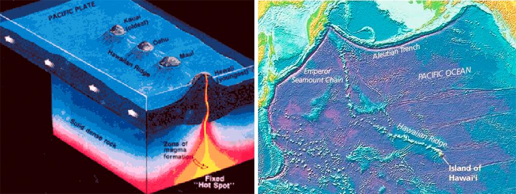
The creation and location of the Hawaiian-Emperor Seamount chain, Hawai'i Volcanoes National Park / USGS-NPS
The Hawaiian-Emperor Seamount chain extends over 3,700 miles (5,954.6 km) and is the result of hot spot volcanism. A hot spot is a plume of localized high heat energy that remains in place while plate tectonics shift above it. The hot spot creates volcanic eruptions which overlap each other and build up toward and then above the sea. Picture a conveyor belt. This plume of heat energy remains stationary while the plates (the conveyor belt) continue moving. As long as there is continued heat and magma from that hot spot, more submarine mountains resulting in islands are formed until the heat finally cools or is diverted elsewhere. According to the United States Geological Survey (USGS), the Pacific Plate, upon which sit the Hawaiian Islands, moves an estimated 2 – 4 inches (6 cm) per year.
As the plates move the islands in this chain away from that stationary hot spot, the volcanoes on that island become less active since the heat source has been removed. Kauai is the oldest island in this chain, and the Big Island of Hawai’i is the youngest, since it is still over that hot spot and still volcanically active.
There are a total of five volcanoes on Hawai’i. Mauna Loa is the largest active volcano, and Kīlauea is the youngest active volcano. Often, a volcanic eruption is presaged by a seismic tremor or series of tremors.
You can read about all the eruptions that have occurred by clicking here.
You can read a more detailed explanation of Hawai’i Volcanoes geology from this USGS web page.
If you really want to keep an eye on things, click here to view Kīlauea from the USGS Hawaiian Volcano Observatory webcams, and view a live stream of Kīlauea here. To view the USGS Hawaiian Volcano Observatory webcam positioned on the north rim of Mokuʻāweoweo, the summit caldera of Mauna Loa volcano, click here.

A ribbon of red-hot lava, Hawai'i Volcanoes National Park / Rebecca Latson


