There are numerous trails in both East and West districts of Saguaro National Park in Arizona allowing you plenty of opportunities to explore the Sonoran Desert scenery and environment. If you would rather see the landscape on two wheels, you can bicycle either of the park’s loop roads in addition to several trails.
Hiking
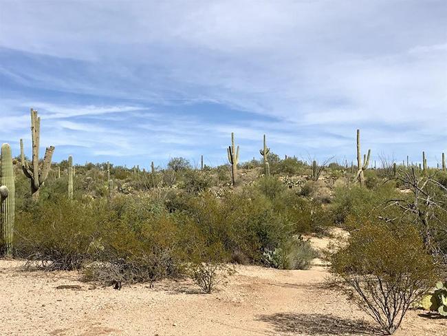
The view along the Freeman Nature Trail, Saguaro National Park / Kurt Repanshek
Hiking trail distances range between 1 mile (1.61 kilometers) to 8 miles (12.9 kilometers) in the Rincon Mountain District (Saguaro East) and between 0.4 mile (0.64 kilometer) to 8 miles (12.9 kilometers) in the Tucson Mountain District (Saguaro West).
Of the various trails in Saguaro, below are a few hiking suggestions by park staff.
Rincon Mountain District (East)
Freeman Homestead Trail
Distance roundtrip: 1 mile / 1.61 kilometers
Wander down this path to the site of an old homestead foundation, a grove of large saguaros and a cool desert wash. Great Horned Owls can often be seen in the cliff above this wash.
Loma Verde Loop
Distance roundtrip: 3.8 miles / 6.12 kilometers
Elevation gain: 60 feet / 18.3 meters
The trailhead leads through a grove of mesquite trees, beyond a seasonally flowing wash, and up a bluff onto the bajada, the Spanish word for a gravel plain at the base of a mountain. Pass the Loma Verde Mine and take a right on the Pink Hill Trail. A short spur trail leads to a fine overlook of the cactus forest and Tanque Verde Ridge. Take a right on Pink Hill Trail, then turn right on the Squeeze Pen Trail. You will then take a left on the Loma Verde Trail and head back to the trail head.
Hope Camp and Ridgeview Trail
Distance roundtrip: 2 miles / 3.22 kilometer
Elevation gain: 400 feet / 122 meters
This area was an old homesteading road and used to drive cattle to a line camp. As you start to climb up in elevation, views of Rincon Peak begin after a brief slope, which only increase as you go up in elevation. Towards the end of the trail, incredible panoramic views and brilliant seasonal wildflowers fill the hillside. The trail ends at the top, which shows an incredible view into Box Canyon, a major drainage in the park. Waterfalls can be seen on the ridge during wetter times.
Garwood Dam and Wildhorse Tank
Distance roundtrip: 6.4 miles / 10.3 kilometers
On this trail, you'll enter the kind of cactus forest that inspired the creation of this park in 1933. A steep section will lead to the Garwood Dam, built by Nelson Garwood in the 1950's. While following a series of switchbacks, you’ll start seeing views on a ridge in the foothills. Beyond the ridge, you will intersect with Wildhorse Trail. Turn right to go on a steep (.3 mile) trail to Little Wildhorse Tank, one of the only perennial areas of water in the park. Continue back (right) onto Carrillo trail until you reach the steel tank. Continue down the wash and take a left out of the wash, still on the Carrillo trail. This section has incredible views of the Santa Catalina Mountains to the north. Finally, turn left and head down the Douglas Spring trail, bringing you back to the trailhead.
Tanque Verde Ridge Trail
Distance roundtrip: Varies
Elevation gain: Varies
This trail is as long or as short as you wish it to be, depending upon how far you want to go. The difficulty level is listed as strenuous, but the views and wildflowers (when in season) are worth it. You’ll be able to see south, west, and north at multiple other mountain ranges and the Tucson Basin. A crested saguaro (at mile 2.5) is a unique view, as well as "the Dome" (a large exposed surface at mile 3) that offers even more breathtaking views. This trail continues to Juniper Basin Campground (6.9-mile mark, 3000 feet elevation) as well as Tanque Verde Peak (8.7 miles, 4000 feet elevation).
Tucson Mountain District (West)
Wild Dog Trail
Distance roundtrip: 1.8 miles / 2.9 kilometers
Saguaro cactus and Sonoran Desert vistas meet you all along the way. If your group has hikers and non-hikers, the hikers could be dropped off at the beginning of the trail while non-hikers drive around the loop and pick them up at the end or at Signal Hill picnic ground. The Signal Hill Road adds 0.5 miles to the hike.
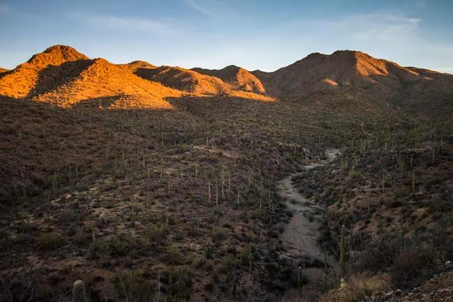
The view along the King Canyon Trail, Saguaro National Park / Jessica Morgan via NPS
King Canyon / Gould Mine Loop
Distance roundtrip: 2.4 miles/ 3.9 kilometers
Elevation gain: 380 feet / 115.8 meters
Take the King Canyon Wash trail up the sandy wash bottom between the canyon walls to the junction and return via the King Canyon trail (an old mining road). There are several rocky "stair-step like" sections in the wash bottom. Also due to moisture, there may be bees present.
Sendero Esperanza Trail to the Ridge/ To Wasson Peak
Distance roundtrip: 3.4 – 8 miles / 5.47 – 12.9 kilometers
Elevation gain: 220 – 1,600 feet / 67 – 488 meters
Great panoramic scenes of the valley come into view as you hike up switchbacks after a relatively flat first mile. Continue to Wasson Peak, the highest point on the west side of the park.
Bicycling
Where ever you choose to bike, it’s a great idea to start out early during the cool hours of the morning to avoid the mid-day heat. This is especially important during the summer.
Below are suggestions on where to bicycle within Saguaro National Park. E-bikes are welcome in this park but are permitted only where traditional bicycles are allowed. Except where motor vehicles are allowed, using the electric motor to move an e-bike without pedaling is prohibited. State laws concerning e-bikes apply within Saguaro National Park.
Rincon Mountain District (East)
Cactus Forest Loop
Distance: 8 miles / 12.9 kilometers
Except for the spur gravel road to Mica View Picnic Area, this loop is paved and takes you through the scenery of the lower elevations in this district. The only is a scenic route through the lower elevations of the Rincon Mountain District. This road is open to all vehicles, bicycles and pedestrians and is narrow with multiple tight turns and steep hills.
The paved Cactus Forest Loop Drive is a great route for bicycling at Saguaro National Park / NPS file
Cactus Forest Trail
Distance one-way: 2.5 miles / 4 kilometers
This is a very thin trail with eroded sections that may make it dangerous for bikers and hikers alike.
Hope Camp Trail
Starting at the Loma Alta trailhead from the end of Camino Loma Alta, this trail travels east through the southwestern portion of the Rincon Mountain District to the park's boundary approximately .2 miles south of Hope Camp. Beyond Hope Camp, the trail connects the Arizona Trail and continues south into the Rincon Valley. Bikes are allowed on the Arizona Trail.
Tucson Mountain District (West)
Bajada Loop
Distance: 6 miles / 9.7 kilometers
With the exception of a small section along Kinney and Sandario Roads, this is a gravel route taking the rider through the lower elevations of the Tucson Mountain District of the park. These roads are open to all vehicles, pedestrians, and bicycles. Biking is only permitted on the roads. Riding on trails around this loop is not permitted.
Golden Gate Multi-use Trail (section of Golden Gate Road no longer accessible by car)
This is a wide gravel path that can be biked. Entrance points are at the end of Golden Gate Road on the Bajada Loop or off Picture Rocks Road.
While you are out and about with your bike, why not cycle around Tucson as well. This is considered one of the most bicycle-friendly cities in the United States.
It is important that you know the park's rules and regulations for cyclists and mountain bikers.


