Hawai’i Volcanoes National Park offers plenty of day hikes for all skill levels. Even if you only have a little bit of time to spend in the park, there are short hikes leading you through rainforests and past volcanic features. For those with more time, there are much longer hikes across solidified lava lakes and around the crater rim of Kīlauea volcano, as well as over rolling, grass-covered land once a part of one of the biggest cattle ranches in Hawai’i.

Looking below to the Kīlauea Iki Trail, Hawai'i Volcanoes National Park / Rebecca Latson
Hike Featured In The Traveler
Kīlauea Iki Trail
Imagine a lake of roiling, bright yellow-orange lava with a molten fountain gushing 1,900 feet into the sky. Now, imagine a calmer day much later, during which you walk upon a slightly undulating, smoothed solid rock expanse where that lava lake once sloshed.
Steeply-sloping walls blanketed with rain forest vegetation rim this now-solid lake edged with chunky blocks of cinder and blobs of fused molten lava called “welded spatter,” which broke apart” into “coarse jagged pieces of rock.” A tall cinder cone, still steaming in places, flanks your right as you walk across the “lake” toward the other side, guided by rock cairns called “ahu.” That’s the experience hiking the Kīlauea Iki Trail in Hawai’i Volcanoes National Park. Of all the trails in this volcanic national park, the Kīlauea Iki Trail is a must-do for your bucket list. You’ll experience both the park’s rain forest environment and a reminder of Pele’s fury while wandering the remains of what was once an active eruption and churning lava lake.
For more details on this hike, head to this page.
Here's a quick rundown of the park’s day hikes. For more detailed information about each hike, click on the trail’s name. You can also download and print out trail guides for a couple of these hikes, or purchase a published version for $2 at the Kīlauea Visitor Center.
Crater Rim Trail – Difficulty Level: Easy
Accessible from several locations, this trail makes an 11-mile (17.7 km) circuit approximately following Crater Rim Drive.
Maunaulu / Pu‘uhuluhulu - Difficulty Level: Moderate
2.5 miles (4.0km) roundtrip
Experience a lava landscape from the 1969-1974 Maunaulu flow. Walk by lava tree molds and climb 210 feet (64m) to the top of a forested cinder cone, Pu‘uhuluhulu (hairy hill). View Maunaulu's steaming shield, which is similar to the now inactive Pu‘uʻō‘ō cone in the distance. On a clear day you can see Mauna Loa, Mauna Kea and the Pacific Ocean.
Puʻuloa Petroglyphs - Difficulty Level: Moderate
1.4 miles (2.25 km) round trip.
Walk in the footsteps of the kūpuna (elders) to Puʻuloa (hill of long life), a sacred and awe-inspiring gallery of kiʻi pōhaku (images carved in stone).
Keanakākoʻi Crater - Difficulty Level: Easy
1 mile (1.6 km) one way, 2 miles (3.2 km) roundtrip.
Keanakākoʻi, meaning "cave of the adzes", likely formed during the 1400s, during the great summit collapses of Kīlauea.
Ha‘akulamanu (Sulphur Banks) - Difficulty Level: Easy
1.2 mile (2 km) round trip
At Ha'akulamanu (Sulphur Banks), volcanic gases seep out of the ground along with groundwater steam. These gases are rich in carbon dioxide, sulfur dioxide and hydrogen sulfide -- the gas that smells like rotten eggs. Some sulfur gases deposit pure crystals at Sulphur Banks. Other sulfur gases form sulfuric acid which breaks down the lava to clay. This clay is stained red and brown with iron oxide.
Halema‘uma‘u Trail - Difficulty Level: Moderate
0.8 miles (1.3 km) one-way from Crater Rim Trail to the floor of Kaluapele (Kīlauea caldera).
1.3 miles (2.1 km) one-way from Crater Rim Trail to the top of Uēaloha (Byron Ledge), allowing for longer hikes to Kīlauea Iki and Nāhuku (Thurston Lava Tube).
Descend 425 feet (130m) through a rain forest that has been re-established numerous times to a panoramic view on the floor of Kaluapele (Kīlauea caldera).
Nāhuku (Thurston Lava Tube) - Difficulty Level: Moderate
1.5 mi (2.4 km) round-trip walk from Kīlauea Iki Overlook. 6.0 mi (9.7 km) round-trip from Devastation Trailhead (including the Kīlauea Iki loop), an additional 1.0 mi (1.6 km) from Puʻupuaʻi
Walk through a verdant rainforest and listen for the calls of native birds before entering a 500-year old lava tube where a river of 2000 degree fahrenheit (1093° celsius) lava once flowed.
Devastation Trail - Difficulty Level: Easy
1 mile (1.6km) round trip
Stroll on a paved path through a starkly beautiful recovering landscape that was buried by falling cinder from the spectacular lava fountains of the 1959 Kīlauea Iki eruption.
Kūpinaʻi Pali (Waldron Ledge) - Difficulty Level: Easy – wheelchair accessible
About one mile (1.6 km) round-trip to the overlook.
The Kūpinaʻi Pali (Waldron Ledge) portion of Crater Rim Trail is a walk through history, leading to a panoramic view of Kaluapele (Kīlauea Caldera) and Halemaʻumaʻu crater.
Kīpukapuaulu - Difficulty Level: Easy
1.2-mile (1.9km) loop.
The walk will take you through a "kīpuka", an area of older vegetation surrounded by a more recent lava flow from Mauna Loa.
Maunaiki and Footprints Area - Difficulty Level: Easy walk between the Kaʻū Desert Trailhead on Highway 11 and the Footprints shelter, moderate between Maunaiki and the Maunaiki Trailhead on Hilina Pali Road.
1.8 mi (2.9 km) from the Kaʻu Desert Trailhead to Maunaiki.
7.0 mi (11.3 km) from Maunaiki to the trailhead on Hilina Pali Road.
In 1790, a dramatic explosion occured at the summit of Kīlauea. The eruption involved a torrent of hot gas, ash, and sand that rained down on the Kaʻū Desert. Caught in the middle of this deadly, suffocating storm were groups of Native Hawaiians travelling through the region on long-used trails. In the newly fallen layer of ash, these groups left behind footprints that we can still see today— a reminder that Hawaiians have beared witness to the geological drama of this island for centuries.
Uēaloha (Byron Ledge) - Difficulty Level: Moderate
1.1 miles (1.8 km) one-way from Devastation Trailhead to the intersection with Kīlauea Iki trail. Stay to the left at the intersection with the Devastation Trail.
Uēaloha (Byron Ledge) is also accessible via a 1.3 mile (2.1 km) hike on Halemaʻumaʻu Trail near Volcano House.
Dividing Kīlauea caldera and Kīlauea Iki crater, Uēaloha (Byron Ledge) provides excellent views of Puʻupuaʻi cinder cone and sporadic vistas of Kīlauea caldera. The trail makes for an excellent connection to the Kīlauea Iki loop as well as Nāhuku (Thurston Lava Tube).

Hikers resting atop a pu'u in the Kahuku Unit of Hawai'i Volcanoes National Park / NPS file
Located on the volatile shoulders of Mauna Loa, the Kahuku Ranch was once one of the biggest cattle ranches in Hawaiʻi, producing beef and hides for more than 150 years. The apparent tranquility of ranch-life, however, was punctuated by volcanic violence that continues to transform the land to this day. Click on the link above to see the available hikes in this unit.
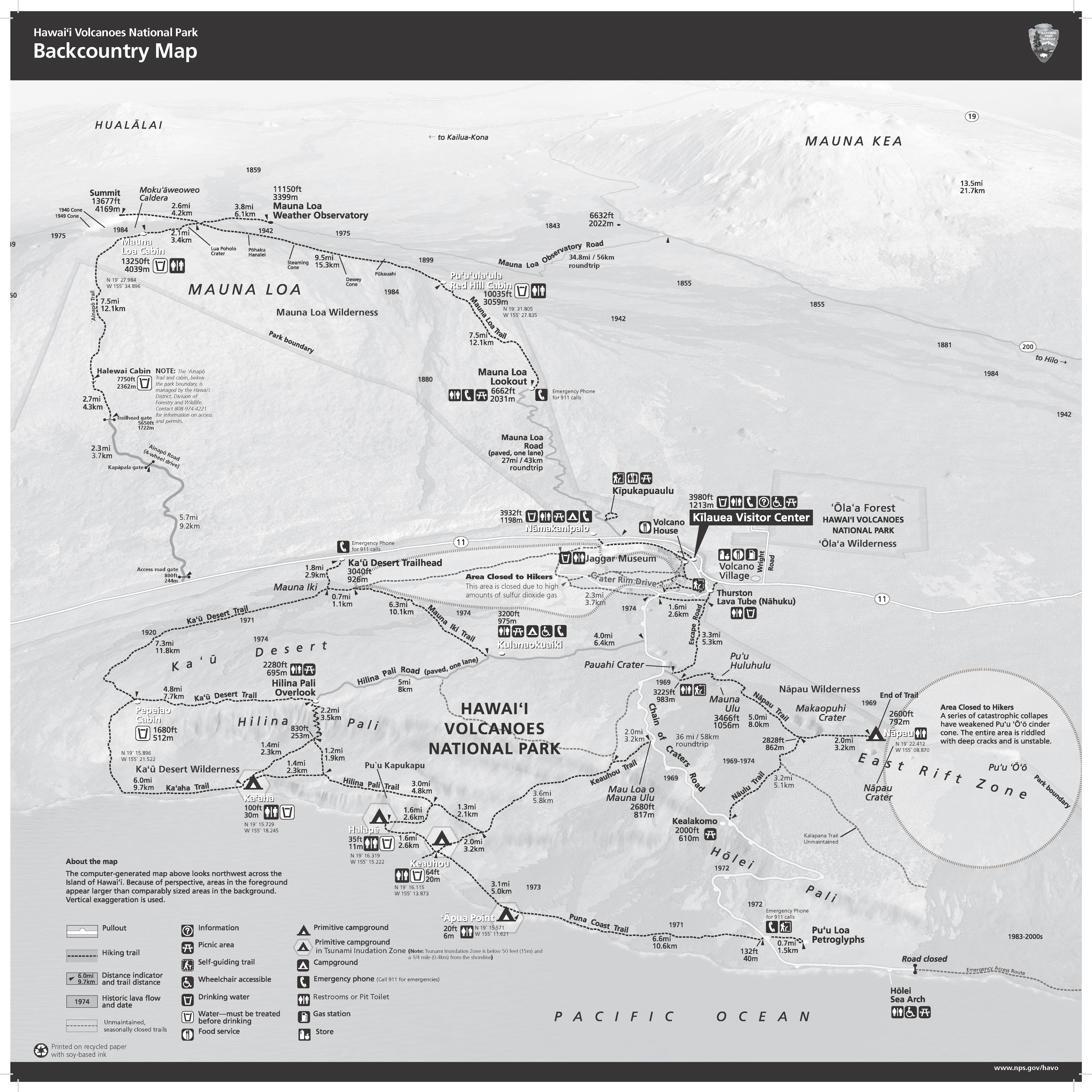
Backcountry Hiking

A backcountry view of Halapē landscape, Hawai'i Volcanoes National Park / NPS file
For backcountry hikes, you can download and print out Page 1 and Page 2 of the park’s Backcountry Planner. You’ll need a backcountry permit for overnight stays in the park.


