Cave tours are extremely popular at Mammoth Cave National Park in Kentucky, but there’s plenty to do above ground too, like hike the almost-80 miles (128.75 km) of frontcountry and backcountry trails within the park’s boundary.

Hiking near Mammoth Cave's historic entrance, Mammoth Cave National Park / NPS - Nathaniel Leies
You’ll hike limestone ridges and view karst landscape, forested rolling hills, and springs that disappear beneath the ground. You might even come upon a small, quiet cemetery where rest the remains of people who called this place home before it ever became a national park.
Visitor Center and South Side Trails
There are about 18 miles (29 km) of trails on the south side of the park, 7.2 miles (11.6 km) of which have trailheads within the area near the visitor center. The table below lists the trails and their one-way distances.
Trail | Starts at | Mi. | Km. |
Amphitheater Trail | Hotel parking/ Cavers' Camp Store | 0.2 | 0.3 |
Cabins Trail | Hotel Parking | 0.2 | 0.3 |
Dixon Cave Overlook Trail | Picnic Area | 0.1 | 0.1 |
Dixon Cave Trail | Historic Entrance | 0.4 | 0.6 |
Echo River Springs Loop Trail ♿ | Green River Ferry | 1.0 | 1.6 |
Engine No. 4 Trail ♿ | Hotel Parking/ Cavers' Camp Store | 0.2 | 0.3 |
Green River Bluffs Trail | Picnic Area | 1.3 | 2.1 |
Heritage Trail ♿ | Mammoth Cave Hotel | 0.5 | 0.8 |
Historic Entrance Trail | Visitor Center | 0.2 | 0.3 |
Mammoth Cave Railroad | Near Engine No. 4 | 0.2 | 0.4 |
Mammoth Cave | Park Amphitheater | 0.2 | 0.3 |
Old Guides Trail | Heritage Trail/ Historic Entrance | 0.1 | 0.1 |
River Styx Spring Trail | Historic Entrance | 0.4 | 0.7 |
River Valley Trail | Sinkhole Trail/ Echo River Springs Trail | 0.3 | 0.5 |
Sinkhole Trail | Heritage Trail/ Echo River Springs Trail | 1.0 | 1.7 |
Sunset Point Trail | Heritage Trail/Echo River Springs Trail | 0.3 | 0.5 |
Two Springs Trail | River Stix Trail/Echo River Springs Trail | 0.6 | 1.0 |
Whites Cave Trail | Sinkhole Trail/ Mammoth Cave Campground Trail | 0.6 | 1.0 |
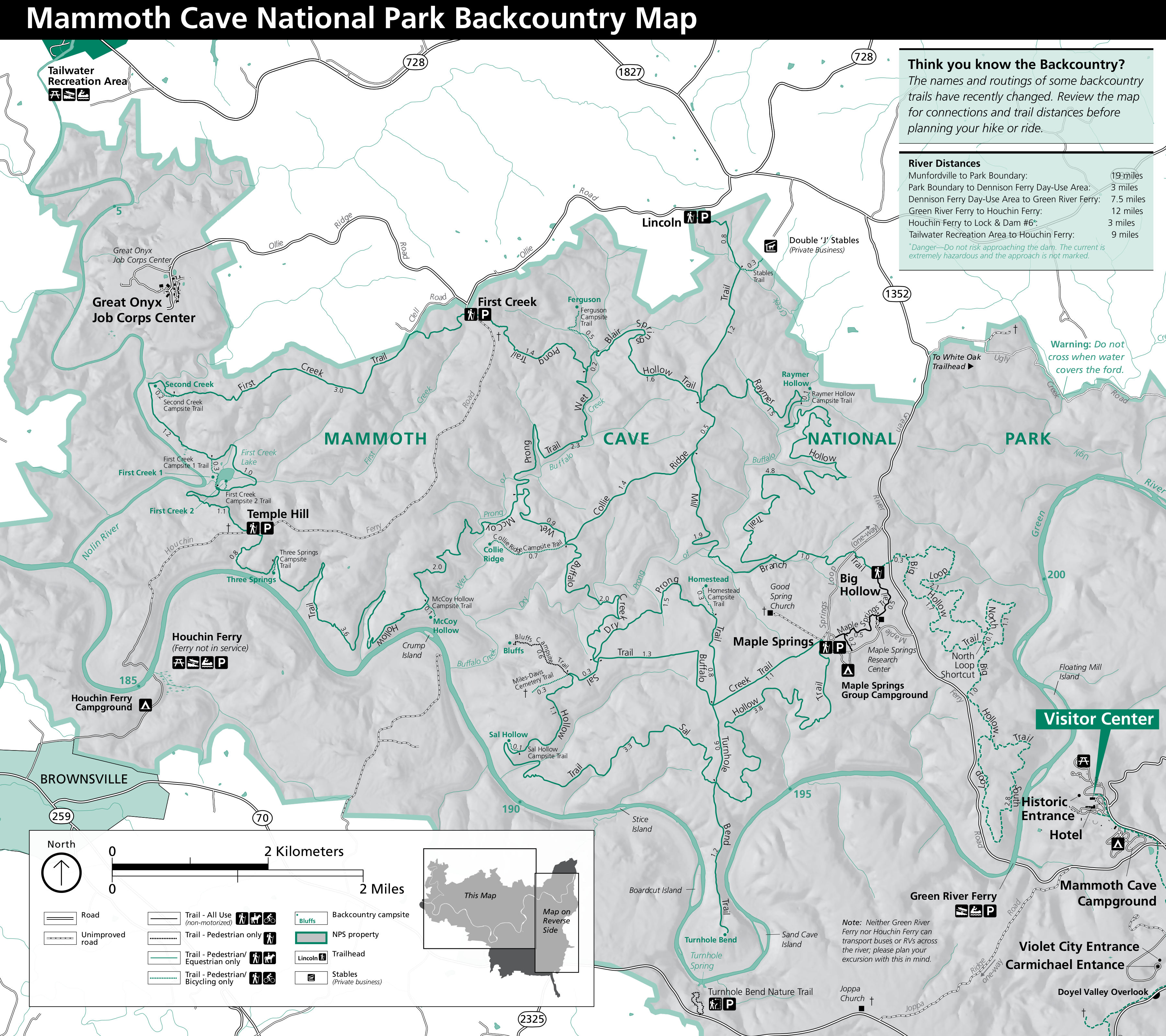
North Side/Backcountry Trails

Hiking the Bluffs Trail, Mammoth Cave National Park / NPS - Anya Gupta
If you are visiting the north side of Mammoth Cave National Park, you’ll have 60 miles (96.6 km) of trails available for exploring.

Backcountry trails map, Mammoth Cave National Park / NPmaps.com
The north-side trails below are listed with one-way distances.
Trail | Starts at | Mi. | Km. |
Big Hollow Trail North Loop | Big Hollow TH | 5.3 | 8.6 |
Big Hollow Trail North Loop Shortcut | Big Hollow Trail North Loop | 0.1 | 0.2 |
Big Hollow Trail South Loop | Big Hollow Trail North Loop Junction | 3.7 | 6.0 |
Blair Springs Hollow Trail | Collie Ridge Trail/ Wet Prong Trail | 1.8 | 2.9 |
Bluffs Campsite Trail | Sal Hollow Trail | 0.6 | 1.0 |
Buffalo Creek Trail | Maple Springs TH | 4.4 | 7.0 |
Collie Ridge Trail | Lincoln TH | 3.8 | 6.2 |
Collie Ridge Campsite Trail | Collie Ridge Trail | 0.7 | 1.1 |
Dry Prong Trail | Buffalo Creek Trail | 2.4 | 3.9 |
Ferguson Campsite Trail | Blair Springs Hollow Trail | 0.5 | 0.9 |
First Creek Trail | First Creek TH/Temple Hill TH | 6.3 | 10.2 |
First Creek Campsite 1 Trail | First Creek Trail | 0.3 | 0.5 |
First Creek Campsite 2 Trail | First Creek Trail | 0.1 | 0.1 |
Homestead Campsite Trail | Dry Prong Trail | 0.3 | 0.4 |
Maple Springs Trail | Maple Springs TH | 1.0 | 1.6 |
Maple Springs Campground Trail | Maple Springs Trail | 0.2 | 0.3 |
McCoy Hollow Trail | Temple Hill TH/ Wet Prong Trail | 6.4 | 10.3 |
McCoy Hollow Campsite Trail | McCoy Hollow Trail | 0.1 | 0.2 |
Miles-Davis Cemetery Trail | Sal Hollow Trail | 0.4 | 0.6 |
Mill Branch Trail | Maple Springs Trail/Collie Ridge Trail | 3.0 | 4.7 |
Raymer Hollow Trail | Mill Branch Trail/ Collie Ridge Trail | 6.2 | 9.9 |
Raymer Hollow Campsite Trail | Raymer Hollow Trail | 0.1 | 0.2 |
Sal Hollow Trail | Maple Springs TH | 8.6 | 13.8 |
Sal Hollow Campsite Trail | Sal Hollow Trail | 0.1 | 0.2 |
Second Creek Campsite Trail | First Creek Trail | 0.2 | 0.3 |
Stables Trail | Collie Ridge Trail | 0.2 | 0.4 |
Three Springs Campsite Trail | McCoy Hollow Trail | 0.1 | 0.1 |
Turnhole Bend Trail | Buffalo Creek Trail | 1.8 | 2.9 |
Wet Prong Trail | First Creek TH/ Collie Ridge Trail | 4.6 | 7.4 |
White Oak Trail | White Oak TH | 2.5 | 4.0 |
While planning for a backcountry hike of more than one day, remember to get a backcountry permit to camp at any of the 13 designated backcountry campsites. As you plan and prepare for your adventure, you should be mindful of backcountry health and safety. Cell service is spotty out in the park’s hinterlands, so be familiar with first aid. Watch your step and watch out for poison ivy, ticks, and snakes. Spraying your clothing and tent with a repellent such as Sawyer-brand permethrin insect repellent is a good precaution against those uninvited ticks wanting to hitch a ride.
To view and print out a copy of the backcountry trails map, click here.
Beneath Your Feet

Lovers Leap at the end of Gothic Avenue, one of the trails Beneath Your Feet at Mammoth Cave National Park / NPS - Jackie Wheet
As you hike above ground, you might wonder what cave features lie just beneath your feat. You can discover those features with the park’s Beneath Your Feet program. Just download the official NPS app and navigate to the Mammoth Cave National Park page on your smartphone or touchscreen tablet. Using the NPS app, you can follow along to the various Beneath Your Feet locations as you walk around the visitor center area. Your smartphone camera application can also be used to scan the QR Code on the Beneath Your Feet wayside signs to open the web link to watch videos and learn more about the cave passage below.


