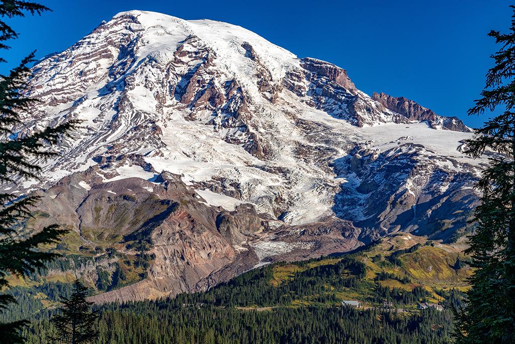
“The Mountain,” around which Mount Rainier National Park in Washington State is located, is a product of fire and ice, just like the other volcanoes of the Cascade Arc along the western side of the United States. The Star of the Show is composed of layers of andesite and dacite lava flows, pumice, and pyroclastic flows (hot ash, lava fragments, and gases), scoured and sculpted by glaciers.

A volcano scoured and sculpted by glaciers, Mount Rainier National Park / Rebecca Latson
Looking at the icy glaciers coating 14,410-foot-tall (4,392 m) Mount Rainier’s flanks, you wouldn’t think it’s an active volcano. But it is. Because of its two steaming craters, which “seem to avoid erosion from glaciation,” The United States Geological Survey (USGS) considers this mountain “… a youthful and active volcano with potential of future volcanic eruptions.”
Plate Tectonics
Cascade Range volcanoes are products of plate tectonics. Think of Earth’s outermost layer as a series of irregular slabs, or sheets, conveyed upon mobile, molten material beneath these slabs. This molten mantle material (the asthenosphere) is constantly in motion, ferrying the sheets all over the globe. Plate movement ranges from one centimeter (2.5 in) to more than 15 centimeters (0.39 – 5.9 in) per year, which sounds negligible until you start adding those centimeters/inches up over the course of millions of years.
The Cascade volcanoes run in a north-south direction paralleling the Pacific Coast for approximately 500 miles (804.7 km). This volcanic mountain chain, including Mount Rainier, is situated along the northwestern boundary of the Circum-Pacific Belt (aka Pacific Rim of Fire), where 90 percent of the world’s earthquakes and most of the world’s volcanism occurs. At this boundary, plates of mostly oceanic crust are sinking (subducting) beneath a larger tectonic plate.

The subduction zone creating the Cascade Range volcanoes / USGS graphic
In the USGS graphic above, the Juan de Fuca plate composed of denser oceanic crust is subducting beneath the North American Plate, made up of lighter continental crust upon which resides Washington State. The water in the material subducted heats up due to high temperatures and pressures at depth, melting the neighboring rocks to create molten magma. Magma is lighter than the surrounding rock and rises back up to the surface, forming chains of volcanoes, including Mount Rainier.
The Mountain
Mount Rainier is a stratovolcano (aka “composite” volcano), composed of silica-rich and gas-rich andesite and dacite lava layers along with pumice and pyroclastic flows. Stratovolcanoes have the most violent eruptions (ex. Mount St. Helens) because of their lava content, unlike the volcanoes of Hawai’i Volcanoes National Park, which extrude a less silica-rich basalt lava.
Scientists do know this volcano first erupted about 500,000 years ago, and have since been able to document eruptions from 420,000 years ago to the last eruption in the 1840s, although the Smithsonian Institution indicates Mount Rainier’s last eruption was confirmed as occurring in 1450, and the other eruptions since then (including the 1840 eruption) are considered “uncertain eruptions.”
The Glaciers

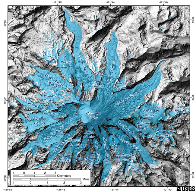
Mount Rainier glaciers overlain on a Lidar map of the terrain, Mount Rainier National Park / USGS
Thanks to Mount Rainier’s height (14,410 ft/4,392 m) and its northerly location, 28 named glaciers and numerous unnamed snowfields grace this volcano’s slopes, making it the most-glaciated peak in the contiguous United States. Emmons Glacier has the largest area (4.3 sq mi/11 sq km) and the Carbon Glacier has the lowest terminus altitude (3,600 ft/1,097 m) of all glaciers in the Lower 48. The USGS states glaciation of Mount Rainier “both preceded and followed the development of Rainier's modern cone, 500,000 years ago,” and the glaciers we see today are much “smaller descendents” of the vast ice that “overwhelmed” the Cascade Range during the Pleistocene (2.58 million-11,000 years).

Emmons Glacier anatomy, Mount Rainier National Park / NPS file
In addition to providing enough water to support five major river systems, Mount Rainier’s glaciers have adorned, scoured, and sculpted the park’s landscape. Walk from the Sunrise parking area to the Emmons Vista Overlook and you’ll be able to see numerous features of Emmons Glacier’s anatomy as noted by park staff:
A) Crevasses are cracks and breaks in the glacier ice, formed as the ice moves unevenly over the slopes of Mount Rainier. The circle around "A" shows a magnified view of a small portion of the crevasses on the Emmons Glacier.
B) Rock debris covers the lower portion of Emmons Glacier. Much of this rock came from a large rock fall in the 1960s. The rock layer helps insulate the glacier's ice from melting and is believed to have contributed to an advance of the Emmons Glacier for a time after the rockfall.
C) Terminus, or end, of the glacier.
D) Water from melting glacial ice leaving the terminus of the glacier. The melt water from the Emmons Glacier is the source of the White River. Streams flowing from glaciers are clouded with fine sediment, called glacial flour, created by the glacier grinding its rocky bed. The glacial flour gives the water a milky color.
E) Outwash Plain, filled with sediment, rocks, and other debris left behind behind the retreating glacier. Outwash plains are further shaped by the glacial meltwater streams, forming braided river beds through a process called aggradation.
F) Terminal Moraine, a large ridge-like formation of rocky debris left behind by the terminus of the glacier as it retreats. Terminal moraines like the one indicated here mark places in the valley that the glacier extended to in the past.
G) Glacial ponds can form if glacier ice broken off the main glacier melts and the water is captured behind a moraine. Terminal moraines can also dam the valley, causing melt water to pool.
H) Lateral moraines are debris ridges forming along the edges of the glacier instead of at the terminus. The large, steep lateral moraines near the Emmons Glacier indicated here were left behind by much larger, ice age glaciers that predated the Emmons Glacier.
Mount Rainier Factoid: this mountain’s magmatic system which provides heat for the fumaroles at the summit also has created the world’s largest volcanic ice cave system, closed to visitors since 1980 due to a changing climate creating unsafe conditions including ice chunks and flakes, some the size of a small car, breaking loose and falling from the cave ceiling.
The Hazards

A distant view of Mount Rainier over Puyallup Valley near Orting, Washington / USGS
Mount Rainier is considered the most dangerous volcano in the Cascade Range. According to the 2005 Geologic Resource Evaluation Report for Mount Rainier:
In terms of its potential impact on human populations, this “mountain of fire and ice” is the most dangerous volcano in the Cascade Range. In the shadow of Mount Rainier, live over 4 million people. The glaciers on Mount Rainier provide a steady flow of water for hydroelectric power in the region, regardless of the season. However, should an eruption occur, these 35 acres [14 hectares] of ice and snow could melt and send debris flows towards Puget Sound and the Seattle/Tacoma metropolitan area.
And that’s not all.
Mount Rainier is considered the second most seismically active volcano in the Cascades, second only to Mount St. Helens.
According to park staff:
In an average month, 1-5 well-located, high-frequency earthquakes are recorded. In addition, small swarms of 5-10 earthquakes over a 2-3-day time period occasionally occur. All of these earthquakes are shallow, with most locating near sea level (~4 km below the summit), and are interpreted … to be occurring in response to stresses associated with the circulation of hot fluids beneath Mount Rainier.
Numerous possible hazards created by a Mount Rainier eruption include lava flows, volcanic ashfall, volcanic projectiles, pyroclastic flows and surges, volcanic gases, debris flows, debris avalanches, lahars (a destructive, fast-moving mixture of water, volcanic ash, rock fragments, and ice that flows down the slopes of a volcano).
According to park staff:
More than 60 lahars have dramatically altered various portions of Mount Rainier during the past 10,000 years. They are one of the most common and powerful forces of change on the volcano since the ice age.
In the 1950s, geologist Dwight "Rocky" Crandell determined that the soil samples from Tacoma and Steamboat Prow came from Mount Rainier's slopes. Crandell and his colleague Don Mullineaux established that the mountain's summit and northeast slope collapsed during a volcanic eruption. Radiocarbon ages of wood from this huge lahar, the Osceola Mudflow, show it occurred 5,600 years ago. [The mountain lost about 1,000 feet of elevation as muddy debris raged down both forks of the White River as far as the Puget Sound. Yellowish, concrete-like outcrops of Osceola Mudflow material can be seen along the trail to Glacier Basin. The enormous amphitheater left behind by this event is clearly visible on the east side of the park.]
When a lahar roared through a forest near present-day Orting 600 years ago, it left behind a jumble of old trees and volcanic rock. The Electron Mudflow emerged on Rainier's west side, beginning with a collapse of clay-rich altered rocks, and continued to Puget Sound. The town of Orting has installed warning sirens connected to sensors on the mountain's slopes. The plan is to evacuate if another lahar approaches.
in 1947, massive amounts of water exploded from the Kautz Glacier, gouging a one-mile-long canyon through the ice. The water swept down the valley, picking up rocks, soil, and debris, scouring vegetation and snapping trees. The largest debris flow since the park was established, the Kautz Creek Mudflow moved 50 million cubic yards (>38 million cubic meters) of debris, dramatically changing the topography and vegetation of the area. Several smaller debris flows followed.
Other debris flows have occurred frequently throughout the history of the volcano, including a small event that damaged trails and temporarily closed the road to Paradise in 2001.
So, when do scientists think Mount Rainier will erupt next? That’s difficult to predict. According to the USGS, however, there will be warning signs in the days, weeks, or months preceding an eruption:
…Small earthquakes centered beneath the volcano, by subtle deformation of the volcano, and by increases in volcanic gas emissions and temperatures.
New eruptions of Mount Rainier will most likely start with steam and ash explosions at the summit, and progress to the effusion of a small lava flow or the disintegration of steeply sloping lava flows as avalanches of hot rock and gas called a pyroclastic flow.
A view of "The Mountain" at Emmons Vista, Sunrise Area, Mount Rainier National Park / Rebecca Latson


