Cuyahoga Valley National Park in Ohio gets its name from the Cuyahoga River, is fed by more than 190 miles of perennial (permanent) and ephemeral (temporary) streams, and the central natural feature of Cuyahoga Valley National Park . Twenty-five miles (40 km) of the river’s 100 miles (161 km) run the length of the park from south to north, so it’s a no-brainer to want to paddle a canoe or kayak through the park on this waterway.

Cuyahoga River Water Trail, Cuyahoga Valley National Park / NPS-DJ Reiser
While the National Park Service does not maintain the river for recreational use, nor does it rent out paddling equipment, you may still bring your own human-powered, non-motorized watercraft.
River Access Sites
There are several river access sites within this national park. Below is a quick rundown of each site. For more detailed information, click on each access site link.

Lock 29 river access, Cuyahoga Valley National Park / NPS-Arrye Rosser
Built in 2023, you can access the river from the Lock 29 Trailhead parking lot in Peninsula. Peninsula Depot and food are nearby.

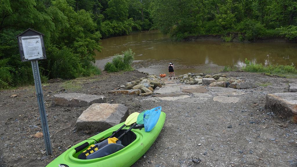
Boston Store Trailhead river access, Cuyahoga Valley National Park / NPS-Elena de Marco
Access the river from Boston Store Trailhead in the Village of Boston. Boston Mill Visitor Center is nearby.

Red Lock Trailhead river access, Cuyahoga Valley National Park / Conservancy for CVNP-Aaron Self
Access the river from the south side of the Vaughn Road bridge over the Cuyahoga River. This bridge is located near Red Lock Trailhead in Sagamore Hills.
Stanton Road Bridge river access, Cuyahoga Valley National Park / NPS-Tim Fenner
Access the river via the Station Road Bridge Trailhead in Brecksville. A mowed path leads from the southeast corner of the parking lot to the river.

Lock 39 river access, Cuyahoga Valley National Park / NPS - Tim Fenner
Access the river from the Lock 39 Trailhead in Independence. This site allows access for a long paddle, nearly 12 miles (19.3 km), into Cleveland. Rockside Station and food are nearby.
Rules and Regulations
According to park staff:
All paddlers on the Cuyahoga River should be familiar with federal, state, and park regulations that apply to the river. Ohio boating laws apply to all paddlers in Ohio, including visitors from other states. The National Park Service does not allow any alcohol to be consumed on Cuyahoga Valley National Park property without a permit.
- ORC 1547.54 All boats—including canoes, kayaks, motorboats, and most inflatable boats—must be registered. Ohio law requires that a boat's registration be carried onboard. Bring proof of residency if you are visiting from a state that does not require canoes or kayaks to be registered.
- ORC 1547.25 US Coast Guard-approved life jackets are required for every person onboard. They must be in serviceable condition and correctly sized for the wearer.
- ORC 1547.24 Children under the age of 10 are required to wear a properly fitted, US Coast Guard-approved life jacket at all times while on a boat under 18 feet (5.5 m) in length.
- ORC 1547.11 Operating any boat under the influence of alcohol or drugs is prohibited. Ohio's limit for impairment is 0.08 blood alcohol content level for persons who are of legal drinking age. It's 0.02 for anyone who is under 21. (Alcohol is not permitted on the river or in the national park without a permit.)
- ORC 1531.29 Disposing of any item considered to be litter in any ditch, stream, river, lake, pond, or other waterway is illegal.
- Children under the age of 12 who are operating a manually propelled boat must be directly supervised by an adult.
- Only human powered vessels are allowed on the Cuyahoga River. Inner-tubes and inflatable toy flotation devices are prohibited.
Respect the rights of landowners. Be aware that some of the land along the river is privately owned. Seek the owner's permission before using any private property.
Commercial use of the Cuyahoga River is not being authorized at this time. For more information visit the park’s permits page.Safety
The park does not maintain the river channel on a regular basis, and stream conditions are ever changing. Paddlers must assume complete responsibility for their own safety.
Swift currents, log jams, and strainers are common and serious hazards on the river. Strainers are downed branches or trees that allow water to pass through. Currents can pull boats into the strainer, trapping the paddler and creating a potential drowning situation. Paddlers should portage around obvious hazards or areas of uncertainty.
After it rains, the water may contain bacteria from combined sewer overflows and storm water runoff. A high level of bacteria in the water can be a health hazard. High bacteria levels can be harmful if ingested or is exposed to cuts on the skin. Most people do not plan to be in the river during their paddling trip, however hazards can occur suddenly and can cause a paddler to flip or capsize. Check the latest water quality information via USGS Great Lakes NowCast. Advisories are posted by approximately 9:15 a.m. daily from May through October.
Visit the water trail’s Plan a Safe Trip page before you leave home.
River water temperature and flow are recorded by the United States Geological Survey. The three nearest gages are: USGS Old Portage Gage, USGS Jaite Gage, or USGS Independence Gage.
Make sure you are aware of your location on the river in case of emergency. In the event of an emergency call the park's Communication Center at 440-546-5945 or dial 911.Note: There is currently a river-wide closure near river mile 17 due to bridge demolition and construction. The closure begins upstream of the Alexander/Pleasant Valley Road bridge and extends to downstream of the construction zone. Barrier cables with marker buoys extend across the river. Travel safely through the area by following temporary portages. One is just upstream of the Fitzwater Road bridge on the west side of the river (river left) and the other is just downstream of the Fitzwater Road bridge on the east side of the river (river right). During the Towpath Trail closure in December 2024 and January 2025, no portage is available north of Fitzwater.


