The Rio Grande River offers paddlers the chance to drift along quietly while enjoying the landscape, or challenge their abilities running the rapids.
There are five canyon locations along the Rio Grande for float trips of a day or more. According to park staff:
Boquillas Canyon
Floating through Boquillas Canyon, Big Bend National Park / NPS file
This 33-mile (53 km) canyon makes for a two- or three-day float trip (depending upon river flow rate and headwinds) complete with quiet spots and Class II rapids.
Put-in: The usual put-in is at the Rio Grande Village river access, located near the group campsites; an alternative location is at the Daniels' Ranch.
Take-out: The Heath Canyon take-out is located on the U.S. side of the river, just downstream of the La Linda bridge. Permission to take-out at Heath Canyon should be obtained by calling Heath Canyon Ranch at 432-376-2235.
Detailed Trip Description by American Whitewater
You can purchase the River Guide to the Rio Grande: Mariscal and Boquillas Canyons online through the Big Bend Natural History Association.
Mariscal Canyon
Canoeing through Mariscal Canyon, Big Bend National Park / NPS - J. Jurado
You’ll need a high-clearance vehicle to reach Mariscal Canyon, so you can be assured of plenty of remote solitude for this one-day float trip. Depending upon water levels, there are a few Class II – III rapids. At water levels above 1000 CFS open boats should use caution.
- Check with a ranger about road conditions along the River Road before embarking on your journey.
- Get Current River Flow Readings Here
- A backcountry permit is required for all overnight river trips
High clearance vehicles are usually required to reach both Mariscal Canyon access locations. Count on two to two-and-a-half hours driving time from Panther Junction to Talley. It is a good idea to go to Solis before you put in at Talley and scout the area to be able to recognize it from the river. It is best to have someone available to drop off your crew and gear at Talley, then meet you at Solis.
Put-in: Talley is the put-in for Mariscal Canyon. Be sure to check road conditions before making your final plans. The river road is rarely passable to passenger cars and sometimes is so rough as to be passable only to four- wheel-drive vehicles. Be especially careful to avoid getting stuck near the end of the Talley road, where you will encounter loose, drifted sand.
Take-out: Solis is the common take-out for the canyon. Be careful not to overshoot—it's a long way to the next one.
Detailed trip description by American Whitewater
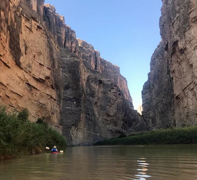
Santa Elena Canyon
Paddling through Santa Elena Canyon, Big Bend National Park / NPS file
This is the most popular overnight or three-day float trip in the park because of its “dramatic beauty” and 1,500 feet (457 m) cliffs on either side of the river. Put-in and take-out are easily accessed by car,
The first 13 meandering miles from the put-in at Lajitas give you a good look at the contrast between the riparian and desert ecosystem. The river becomes more technical in the last seven miles when you have entered the actual canyon. Two miles into the canyon, the largest rapid, the Rock Slide is classified as a Class IV rapid at certain water levels. 300 to 600 CFS is great for open boats. Above 600 CFS is approprate for rafts. A novice should reconsider any trip above 600 CFS flow rate.
A backcountry permit is required for all overnight river tripsSanta Elena Upstream
An enjoyable day trip consists of paddling upstream, from the Santa Elena Canyon Trailhead, a few miles into the canyon, and then returning back downstream (also known as a "boomerang" trip).This trip is possible at flow rates under 200 cfs. 100 cfs is ideal. Less than 100 cfs will require some dragging boats. Check current CFS rates here. If the water level is low, you do not have to fight the current much going upstream, making this trip quite leisurely. It is an ideal trip if you only have one vehicle, or if you do not want to pay for a shuttle back to your starting point. A backcountry use permit is required for all river trips; no fee is charged for day-use trips.
Detailed trip description by American Whitewater
You can purchase the River Guide to the Rio Grande: Colorado and Santa Elena Canyons online through the Big Bend Natural History Association.
Border Activity Notice: Illegal border crossings are known to occur in this area. If you encounter anything that appears illegal, suspicious, or out of place, please do not approach or intervene. Note the location, description, time, direction of travel, and call 911 as soon as possible.
Hot Springs and San Vicente Canyons
Canoeing the river through Hot Springs Canyon, Big Bend National Park / NPS file
Located between the river access at Solis and Rio Grande Village, these two small river canyons comprising 20 miles of floating are not regularly paddled. They offer plenty to see with few hazards. Put-ins for this section of river are located at various points along the primitive River Road, and a rugged high-clearance vehicle is required to access these areas.
Hot Springs Canyon is a relaxing half-to-whole day’s float great for paddlers of all skill levels. Launch at the river put-in near the Gravel Pit campsites along the River Road East (high clearance vehicle required), and float through open desert, past the historic Langford Hot Springs, and through small, but scenic Hot Springs Canyon to the Rio Grande Village take-out. This trip is approximately 5 miles (8 km) long and gentle at most river levels. You will need either two vehicles or arrange a guided trip or shuttle with a local outfitter. There is no overnight camping along this stretch of the river, so day trips only.
San Vicente Canyon, which includes floating through Hot Springs Canyon, makes for a nice overnight float trip from put-in at Solis to take-out at Rio Grande Village.
The Lower Canyons
The Lower Canyons area of the Rio Grande Wild and Scenic River / NPS - Herbert Young
The Lower Canyons between Heath Canyon and Dryden, downstream from Big Bend National Park, make up the heart of the Rio Grande Wild and Scenic River. Wild and isolated, the canyons provide opportunities for solitude and an outstanding wilderness experience. There are no facilities and access is limited due to rough terrain and constraints of private land. The arduous 83-mile (133.6 km) trip takes 7-10 days. Because of the remoteness of the area, help may be many hours or days away. Extensive experience and preparation are absolutely essential.
A 5-to-10-day float trip through the Lower Canyons offers a true wilderness experience. The trip begins at Heath Canyon near La Linda and ends at Dryden Crossing (83 miles / 133.6 km). The Black Gap Wildlife Management Area is a secondary option for put-ins.The terrain along the Lower Canyons is open desert, rugged hills, and deep canyons. Access to the river is difficult below La Linda and most of the land above the riverbank is privately owned. The rapids in the Lower Canyons are Class II-IV.
Flow rates above 600 CFS are safe for a raft...assuming levels are consistent and not dropping! Open boats (canoes/kayaks) are appropriate at 600 CFS or above, with the caveat that higher flows require a greater level of experience. Boaters should be prepared to portage or line boats through some portions of the river at all water levels.Put-in: The Heath Canyon put-in is located on the U.S. side of the river, just downstream of the La Linda bridge. Permission to use access at Heath Canyon should be obtained by calling Heath Canyon Ranch at 432-376-2235. River access at Black Gap Wildlife Management Area is available at Maravillas, 10 miles downstream from Heath Canyon. There is a $12 per person fee and the access pass is available at Barton Warnock Environmental Center, located in Lajitas, TX, online from Texas Parks & Wildlife Department, or anywhere hunting/fishing licenses are sold. Maravillas is closed for river access during deer season.
Take-out: All individuals, groups or group representatives must register a river take out request with Harrison Ranch & Stone to access John's Marina at Dryden Crossing.
Lower Canyons Assumption of Risk release form required
The Lower Canyons section of the Rio Grande passes through extensive private lands. All visitors who float the Lower Canyons of the Rio Grande are required to fill out and sign the following release form:
Assumption of Risks and Agreements of Release and Indemnity form
Please have this form printed, completed, and signed to give to the ranger when you arrange the river permit for your trip.You can purchase the River Guide to the Rio Grande: The Lower Canyons online through the Big Bend Natural History Association.
Remember, a river trips require planning, equipment, some experience, and a permit. Click here for river use regulations. You can obtain the required float trip permit at any visitor center in Big Bend up to 7 days in advance. Consult a river guide book and check with a park ranger for current conditions before embarking on any river trip. Be mindful of accessing private land while on your float trip. There are no facilities and help may be hours or even days away, depending upon location.


Fishing The Rio Grande
If you are thinking of dropping a line for a little fishing, there are only a few places in Big Bend that support fish: The Rio Grande and its two tributaries, Tornillo and Terlingua creeks. Most of the park’s 40 species of fish are minnow-sized, but you can catch catfish (blue, channel, and flathead). Lately, there’s been a decline in the number of fish along the Rio Grande.
According to park staff:
Two species of fish that had once inhabited the river have not been seen since shortly after the creation of dams upstream and downstream. The last American Eel (Anguilla rostrata) was taken from the Rio Grande near Castolon in 1954; later the last Atlantic sturgeon (Acipenser oxyrhynchus) was taken in the lower canyons. In both cases the fish were dependent on traveling to the ocean in order to breed and it would appear that large impoundments have become their misfortune.
You can get a required fishing permit (free) at any of the park’s visitor centers. The Rio Grande is the only place where fishing is allowed in the park.


