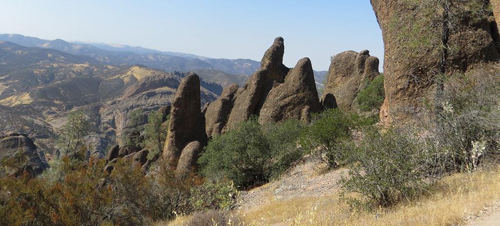
When you visit Pinnacles National Park in California, your eyes of course, will be drawn to those rounded, finger-like spires for which this park gets its name. The landscape, however, wasn’t always what you presently see. It took millions of years for these rocky fingers to form via tectonic plate movement, subduction, volcanics, transform faulting, and erosion.
The Pacific Plate meeting the North American Plate creating a transform boundary (strike-slip fault), Pinnacles National Park / NPS graphic
Plate Tectonics

Graphic of the Farallon Plate and the North American Plate / Opengeology.org
Think of the earth’s crust as a mosaic of dirt-and-rock “sheets” or “plates” that move in conveyor belt fashion atop the more viscous “plastic” rocks of the planet’s mantle. These relatively rigid pates move at a rate of roughly 0-10 cm (~4 in) annually, bumping into, plowing over, moving beneath (subducting), or sliding past each other. This movement doesn’t really seem like much until you multiply it over millions of years.
Subduction
About 60 million years ago, the oceanic Farallon Plate moved beneath (subducted) the larger North American Plate. Think of shoveling snow. As your shovel “subducts” beneath the snow layer and you push that shovel along a straight line collecting the snow on your driveway or sidewalk, you’ll notice the snow forming ridges and cracks as it crumples up against more snow on that moving shovel. In a similar manner, the North American Plate shoveled seafloor sediments off the subducting Farallon Plate. Those bulldozed sediments crumpled up against the North American Plate to create a wrinkled set of north-south ridges like kilt pleats. These ridges became the California Coast Ranges.
As one tectonic plate subducts beneath another tectonic plate, tension cracks and fissures form topside, creating conduits allowing the molten rock beneath to escape via volcanic eruptions. This very activity occurred as the Farallon Plate continued subducting, and thus was born the Pinnacles Volcanic Field 20-23 million years ago.
Eventually, subduction ended and the magma stopped fueling volcano formation and eruptions. The processes of wind and water took over and began eroding that volcanic landscape. That’s not the end of things, however. Along came the very large Pacific Plate, which rammed into the North American Plate.

Graphic of the Farallon Plate subducting beneath the North American Plate, resulting in the creation of a volcanic field, Pinnacles National Park / NPS graphic
Transform Boundary
According to park staff:
[The Pacific Plate] ground against the North American plate’s western edge until a small portion of the American plate snapped along the stress lines and became attached to the Pacific plate’s upper edge.
A transform boundary had come into being. And so had the San Andreas Fault zone, a crack in the earth that stretched more than six hundred miles from the Gulf of California to the Mendocino coast north of San Francisco. Directly in its path, and now astride the two plates, was the Pinnacles volcanic field. As the newly broken sliver of California began its strike-slip displacement journey northwest, thanks to the movement of the Pacific plate, it took with it two-thirds of the Pinnacles’ volcanic mass. Pinnacles now lies 195 miles north of its birthplace near Los Angeles, CA. The journey is far from over, however, as the San Andreas Fault zone continues to slip at a rate of one inch/year.The Pacific Plate meeting the North American Plate creating a transform boundary (strike-slip fault), Pinnacles National Park / NPS graphic
Somewhere along the way, the partial volcanic field -- trapped between the San Andreas on one side and a lesser fault (now called the Pinnacles fault) on the other -- began sinking downward until most of its bulk lay in a graben or ditch where it was protected by the fault-line ramparts rising high above it. In time the ramparts eroded, exposing Pinnacles to the full fury of wind, rain, and ice.
Thousands of feet of overlying rubble gradually wore away. Steep ravines developed; monoliths and colonnades took their place beside massive walls and lonely pillars; boulders fell from lofty recesses to overtop narrow stream channels [creating talus caves].

Rocks Of Pinnacles National Park
Climbers of all skill levels enjoy the challenge of ascending this national park’s canyons, cliffs, and spires. What is it about these rocks that make Pinnacles such a climber’s paradise?
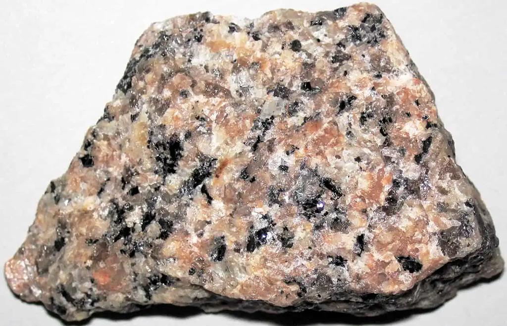
An example of granite / Wikimedia Commons
Starting at the bottom, a granitic basement is the very foundation of the park and the surrounding landscape. Granite is an intrusive volcanic rock composed of quartz, feldspar, and mica. The individual crystals in granite’s makeup are large because the rock cooled slowly beneath the earth’s surface. Had it cooled on the surface, the crystals composing the rock would be very small and almost unidentifiable with the unaided eye.
Atop this granitic basin are the rocks creating the formations we see today:

A breccia example - note the angular rocks differentiating it from a conglomerate / Geology.ECU-EDU
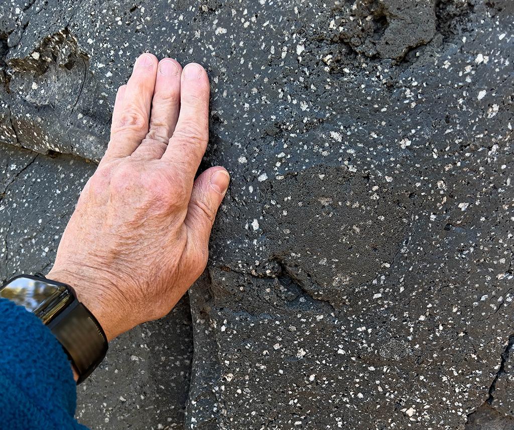
- Breccia: Reddish to gray, formed when molten rock explosively ejects fragments that weld into a lava or tuff matrix. This rock dominates the High Peaks and other formations.

Rhyolite banding example, Pinnacles National Park / NPS file
- Flow-banded Rhyolite: Fine-grained, viscous lava that develops stretch marks, similar to taffy, as it cools.

Pumice lapilli tuff, Pinnacles National Park / NPS via Facebook
- Pumice Lapilli Tuff: A welded volcanic ash composed of sand-sized particles. Weathering of magnesium and chromium-bearing minerals likely produces its green hue. The Bear Gulch Nature Center is constructed from this rock.
Perlite example / NPS file
- Perlite: An opaque volcanic glass that cooled rapidly in water.
Dacite example / Rebecca Latson
- Dacite: A light-colored lava rich in quartz and feldspar, associated with dikes at Pinnacles.

Andesite example / NPS via Flickr
- Andesite: Similar to dacite but with a higher content of dark minerals.
Faulting, fracturing along vertical joints, and wind/water erosion have further worn down the rock along these joints to create the landforms within Pinnacles National Park.


