Look at the terrain around you during a visit to Yosemite National Park. From the cliffs in the Yosemite Valley to the light-pink-and-beige domed mountains lining Tioga Road and beyond, it’s all about subsurface rocks (plutons), uplift, erosion, and glaciation. These are the principal geologic actors in the creation of the landscape on which Yosemite National Park was established.

A very large potassium feldspar crystal within the granite rock, Yosemite National Park / Rebecca Latson
Take a closer look at all that rock. You’ll see large and small crystals of quartz (white), plagioclase feldspar (black), potassium feldspar (pink), biotite (a black, platy, shiny mica), and hornblende (rectangular-ish black or green mineral). The rock is granite, and the fact you can see individual mineral grains means the rock cooled very slowly and solidified beneath the earth’s surface. Granite is a plutonic igneous rock.
Ninety percent of Yosemite’s landscape is composed of granitic rocks because the park lies within the heart of the Sierra Nevada Mountain range, created from the uplift and erosion of the 400-mile-long (643.7 km), 60-to-80-mile-wide (96.6 – 128.7 km) Sierra Nevada Batholith – individual masses of granites called plutons coming together to form a very large mass of granite approximately 105 – 85 million years old.
Over millions of years, the Sierra Nevada Batholith was pushed up (uplifted) due to plate tectonic subduction (one tectonic plate sinking beneath another tectonic plate). The sediments atop the batholith were eroded away by the elements and washed into rivers flowing into California’s Central Valley. Think of a person’s head getting a very close shave to reveal the scalp. What was left after those overlying sediments eroded away were the durable granites, eroding at a much, much slower rate.
Here, courtesy of staff at Yosemite, is a primer on the park’s glacial period and how it shaped the topography:
As the world started to cool about 3 million years ago, glaciers began to advance and retreat repeatedly from the range crest. During cold periods, glacial ice covered much of the higher Yosemite area and sent glaciers down most of the valleys. Glaciers deepened and widened previously stream-cut valleys that were later partially filled with sediment. Most of the glacial features in the park reflect the most recent major episode of glaciation, referred to locally as the Tioga Glaciation, which began about 26,000 years ago and reached its maximum extent about 18,000 years ago. During the Tioga Glaciation, glaciers covered most areas in and around Yosemite National Park above 8,900 feet (2,700 m) in elevation.
osemite's landscape would not be the same without the imprint of glaciers. Landforms that are the result of glaciation include glacially polished granite, U-shaped canyons, jagged peaks, rounded domes, waterfalls, moraines, erratics, and glacial lakes.
Glaciers tend to smooth those landforms that are completely buried in ice (such as Lembert Dome) and sharpen those that project above it (such as Cathedral Peak). As glaciers scrape over bedrock, sediment embedded in the ice polishes the granite and leaves behind linear scratches called glacial striations. Many features deposited by glaciers can be seen in the park, such as moraines and erratics, which are solitary boulders transported by glaciers, often long distances, and left behind as the ice melted. The joints (fractures) in the park’s granitic bedrock significantly influenced glacial erosion patterns in this otherwise homogeneous, erosion-resistant landscape.
Glaciers convert narrow, V-shaped, river-carved canyons into broader U-shaped valleys with steep walls and relatively flat floor, due to the erosional power of the moving ice that is extended far up the valley walls. Lyell Canyon and Yosemite Valley are examples of U-shaped valleys. Glaciers carving the main valleys were thicker and had more erosive power than those in tributary valleys. When glaciers retreat, the tributary valleys are left hanging high above the floor of the main valleys, and their streams pitch into the main valleys as waterfalls. Bridailveil, Yosemite, Sentinel, and Ribbon falls are hanging waterfalls. Virtually all the natural lakes in the park are the result of glacial scouring. But even these lakes are transitory, fated to fill with sediment and become meadows. Mirror Lake is an example of a former lake that is now nearly filled with sediment.
Today, rockfalls are the most active geological process in the park, triggered by rain, earthquakes, and even solar heating. These dramatic events continue to shape the valley walls but also pose considerable risk to people. More gradually, sediment fills alpine lakes, and the Maclure and Lyell Glaciers, although melting at a rapid rate, continue to scour the bedrock beneath them. From its granitic domes and waterfalls to its sediment-filled valleys, Yosemite National Park exhibits the past processes of plate tectonics and glaciation along with ongoing weathering and erosion that continue to shape one of America’s most impressive landscapes.
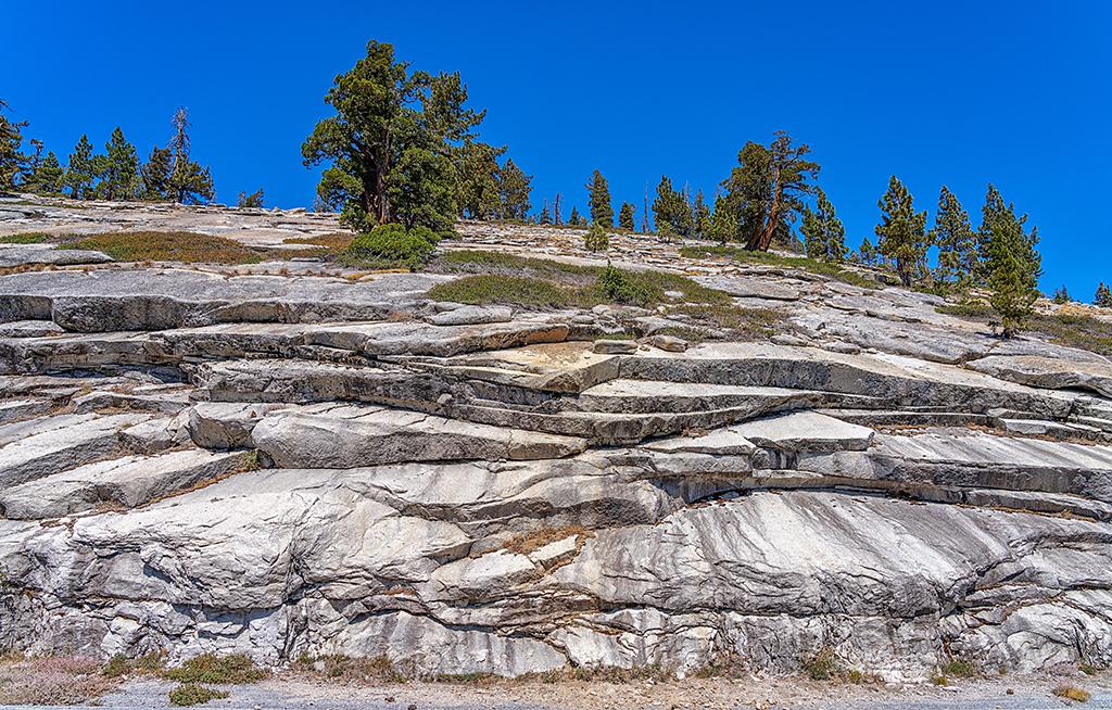
Drive along Tioga Road to view examples of past glacial action and continuing erosion. Note the sheet-like slabs of granite on the slopes, caused by a type of weathering called exfoliation.

Exfoliation weathering of the granite hills along Tioga Road, Yosemite National Park / Rebecca Latson
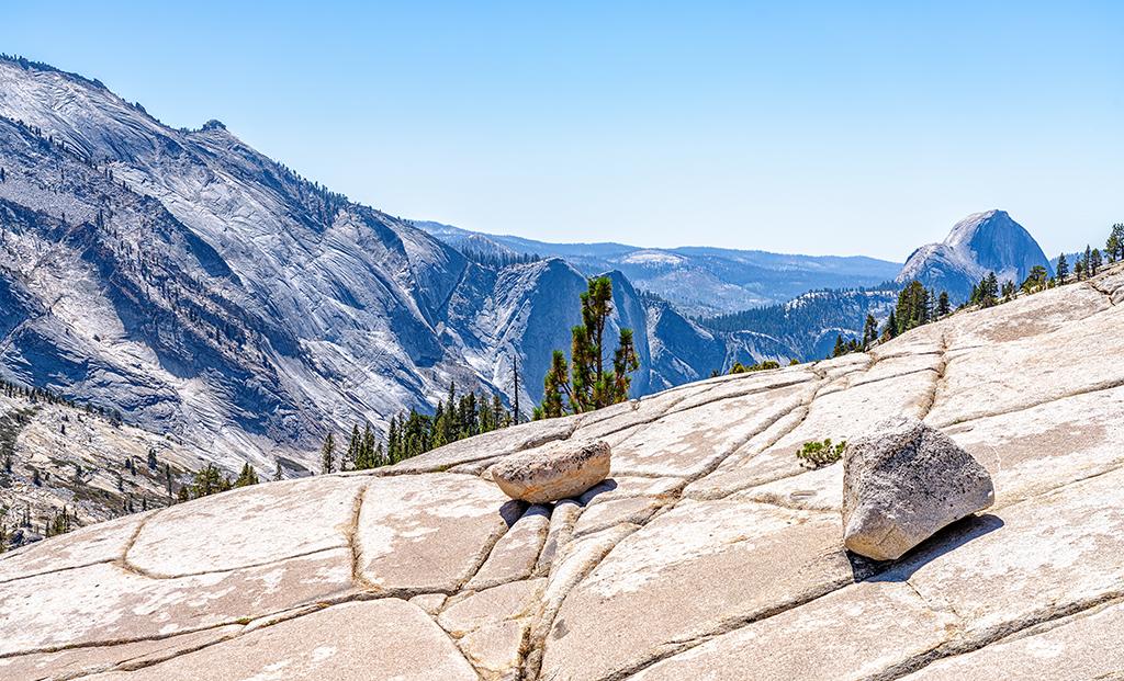
Perk your vehicle at Olmsted Point to see the vast panorama of the granitic Sierra Nevada Mountains and Half Dome. Walk onto the jointed granite surface and make note of the large rocks and boulders known as glacial erratics scattered across the smoothed surfaces.

Glacier erratics upon a jointed granite surface at Olmsted Point, Yosemite National Park / Rebecca Latson
Follow the direction of the joints. Do you notice any trends? These linear joints are the result of tectonic stresses associated with the uplift of the Sierra Nevada, and dictate the flow of water, which in turn dictates what lives within the area, such as this Jeffrey pine, the roots of which grow within these fractures.

The roots of a Jeffrey pine growing within the granite joints, Yosemite National Park / Rebecca Latson
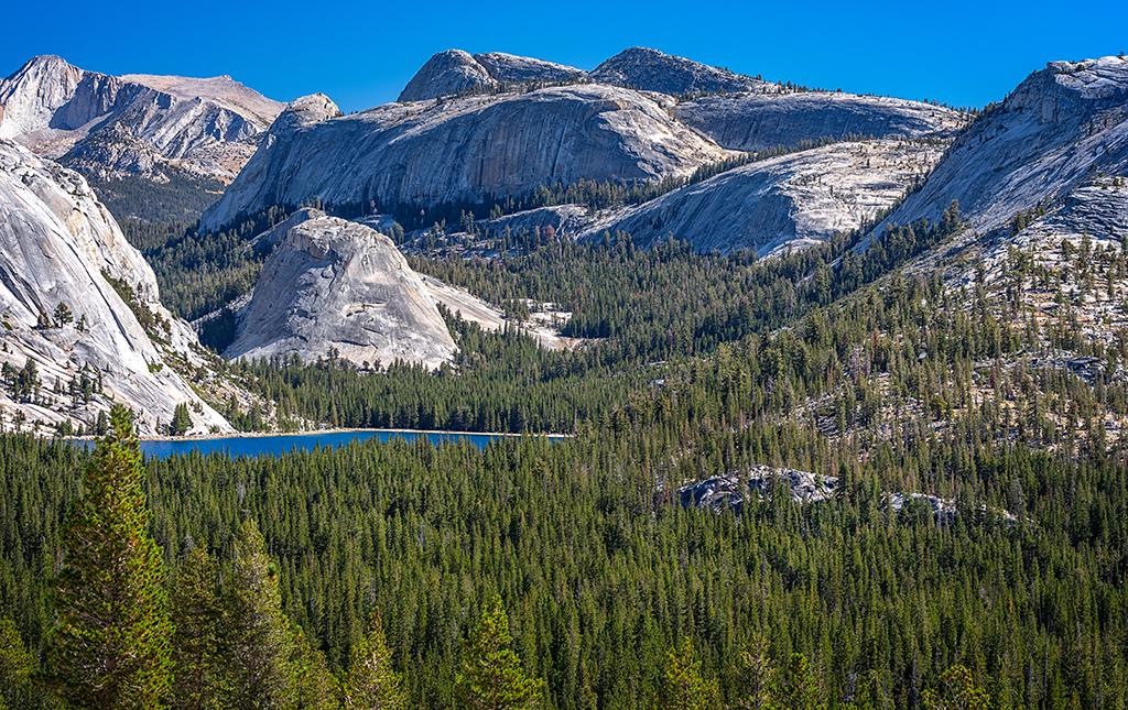
Continue your drive from Olmsted Point toward glacially-carved Tenaya Lake. Stop at one of the pullouts to gaze across to the many rounded granite mountains of the Sierra Nevada.

A view of Tenaya Lake and the High Sierras along Tioga Road, Yosemite National Park / Rebecca Latson
For a more detailed explanation of Yosemite’s geology, you can download this PDF The Geologic Story of Yosemite National Park, USGS Bulletin 1595.


