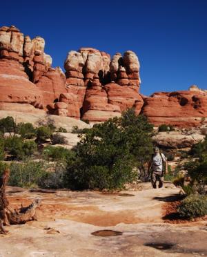
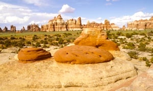
Rock. In every direction you glance in Canyonlands National Park, your eye confronts rock. And whether it's twisted, contorted, or shattered rock, it's also more likely than not incredibly colorful.

What created Upheaval Dome? Canyonlands National Park / Rebecca Latson
A kaleidoscope of tilted and carved geology laid down over the eons -- red and white Cedar Mesa sandstone, the grayish-green Morrison Formation, pinkish Entrada sandstone, tawny Navajo sandstone, just to name a few of the layers -- help make Canyonlands the most rugged national park in the Southwest, and quite possibly if you find yourself deep in the Maze, in the entire Lower 48.
Stand on the lip of Grand View Point atop the park's Island in the Sky District and before you sprawls an immense ruddy landscape in a constant state of decay sweeps before your eyes. From this island of rock you not only can gaze to the horizon through Mesa Arch or climb atop Whale Rock for a gander into Upheaval Dome, but you can look across the deep canyons cut by the Green River as its negotiates Stillwater Canyon.
Though it covers just 337,598 acres in southeastern Utah, or less than one-seventh the landscape of 2.2-million-acre Yellowstone National Park, Canyonlands feels much larger. No doubt the park's openness -- you won't find any forests here -- helps lend that impression. But so does standing from a vantage point that allows your eyes to take in a panoramic sweep of the landscape. You also get that impression striding between the tawny minarets of the Needles District, where you feel dwarfed by the landscape.
 This geologic setting long has fascinated visitors, both for the protection it offers and the features it presents. In the Needles District you can find yourself standing amid rock hoodoos and goblins, check out intriguing and curious formations, (including one dubbed Paul Bunyon's Potty and another known as Wooden Shoe Arch), or view not just a cowboy camp from the early 1900s but also prehistoric archaeological sites.
Canyonlands is a showcase of geology. In each of the districts, you can see the remarkable effects of millions of years of erosion on a landscape of sedimentary rock. For hundreds of millions of years, material was deposited from a variety of sources in what is now Canyonlands National Park. As movements in the earth’s crust altered surface features and the North American continent migrated north from the equator, the local environment changed dramatically.
Over time, southeast Utah was flooded by oceans, crisscrossed by rivers, covered by mudflats and buried by sand. The climate has resembled a tropical coast, an interior desert, and everything in between. Layer upon layer of sedimentary rock formed as buried materials were cemented by precipitates in ground water. Each layer contains clues, like patterns or fossils, that reveal its depositional environment. For example, the red and white layers of Cedar Mesa Sandstone occur where floods of iron-rich debris from nearby mountains periodically inundated coastal dunes of white sand. Only a trace of iron is needed to color a rock red.
It is difficult to imagine such major changes and the time scale they spanned. Equally surprising is the fact that all of these rock layers were flat when they were deposited. Only recently, speaking in geologic time, have these layers eroded to form the remarkable landscape seen today.
Until about 15 million years ago, most of the canyonlands area was near sea level. Local uplifts and volcanic activity had created features like Capitol Reef National Park's Waterpocket Fold and the La Sal Mountains near Moab, but then movements in the earth's crust caused the whole area to rise. Today, the average elevation is over 5,000 feet above sea level, and it's known as the Colorado Plateau.
One could spend a lifetime studying the park's intriguing geology. For those who lack that amount of time, here's a look at some of interesting features you can enjoy on a visit to Canyonlands:
Upheaval Dome
For decades folks have debated what created Upheaval Dome, which can be viewed from the Island in the Sky District. Was it the result of a salt dome that collapsed? Could it have been from the impact of a meteor? How about a giant sinkhole?
Some German researchers believe they've solved the mystery. Their vote is for a meteor. Elmar Buchner and Thomas Kenkmann say the key to their finding was tiny grains of "shocked quartz" -- basically, quartz that has a different microscopic structure from normal quartz due to undergoing extreme pressure of some sort -- that was created by the impact.
Whale Rock
This ponderous sandstone dome, also in the Island in the Sky District, is a guaranteed kid-pleaser, as not only can they scamper up onto the "whale's" back, but from there they can gander into the maw of Upheaval Dome.
Grabens
The grabens in the Needles District are a system of linear collapsed valleys caused by the movement of underlying salt layers toward the Colorado River canyon. The grabens begin near the Confluence of the Green and Colorado rivers and run roughly parallel to Cataract Canyon for about 15.5 miles (25 km), veering slightly west before they end. Graben is a German word meaning ditch or grave. In the geologic sense it is a collapsed or down-dropped block of rock that is bordered on its long sides by faults. Grabens are normally associated with horsts, which are the up-thrown blocks of rock. In German, Horst means aerie, referring to the high nesting sites of predatory birds.

Chesler Park, Canyonlands National Park
Chesler Park
In the backcountry of the Needles District, the redrock landscape with its boulders, spires, and cliffs wraps itself around you. You can get there via the Elephant Hill Trailhead and take the Chesler Park Loop into the backcountry. This is only an 11-mile loop (17.7 km), but since there's no water along the way you'll have to carry all you'll need and so you won't be looking into any really, really long hikes. But the payoff is a landscape of multi-colored spires, sunken grabens, and the extremely narrow "Joint Trail" that will determine whether you suffer from claustrophobia.


