Rugged as it seems, Canyonlands National Park has some great hikes -- both those that head off into the backcountry, and others that take you to interesting sights in the frontcountry.
There might not be a better time to hike Canyonlands than in the spring, thanks to the profuse displays of colorful wildflowers. But no matter which season you find yourself in the park, key to hiking here is preparation.
You need plenty of water, even if you're only sticking to the front-country hikes. Sun protection is paramount, as well, if you hike between April and November. A nice, wide-brimmed hat, good sunglasses, and sunblock will ensure you don't "wear" your hike on your face and any other exposed skin.
Heading into the backcountry? Maps, compass, GPS if you have one, and lots of water are essential. And leave details of where you're going with someone back home.
Hikes Featured on the Traveler
Elephant Hill Trail Towards Chesler Park
Without a doubt, there is no better time to hike in Utah's canyon country than spring. In Canyonlands on the Elephant Hill Trail mid-May blends on one palette the reds, yellows, golds, and whites of wildflowers against a redrock backdrop daubed with cream and buff.
While narrow-leaf yucca were concentrating on sprouting their flower stalks and hadn't yet thought of blooms, and the Mormon tea wasn't quite fully in bloom, claret-cup cactus, Desert Indian paintbrush, orange globemallows, and western peppergrass were in full bloom. And those were just the easy ones to name.
Hike the Elephant Hill Trail, which leads from a backcountry parking area in Canyonlands' Needles District and your eyes jump from the flowers rimming the trail and running across the ground to the surrounding minarets, boulders, and cliffs that define this section of the park.
To read more of this hike, head to this page.
Great Gallery, Horseshoe Canyon Unit
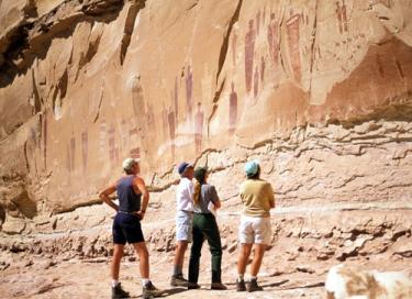
This canyon is worth the 2.5-hour drive from Moab, for it offers a fascinating trip back into prehistory, a time when nomadic tribes would follow the washes through the Southwest's canyon country from camp to camp.
Trek down into it and you'll find the “Holy Ghost” hovering above a sandy wash. Surrounded by lesser figures, the striking specter nearly eight feet tall shimmers on the canyon wall under the relentless sun.
 Ancient nomads created the larger-than-life image perhaps as long as 7,000 years ago by filling their mouths with red ocher-tinted paint and spraying it out with a mighty burst onto the sandstone. The “Holy Ghost” is the focal point of the Great Gallery, a vast mural some 300 feet (91 m) long and featuring about 80 figures ranging from flitting birds and bighorn sheep to bizarre figurines. No one knows for sure what the images represent or why they were painted.
For more details on this hike, head to this page.
Island in the Sky Trails
The Island is perhaps the best destination for families with young children looking for some easy, but spectacular, hikes. Within close proximity to each other are hikes that offer soaring views down into the surrounding canyons cut by the Green and Colorado rivers from this, the highpoint in the park; a visit to the park's iconic arch, Mesa; scampering onto the sandstone back of a "whale"; and visits to ancient granaries left by prehistoric cultures.
Aztec Butte Trail
Length: 2 mi/3 km round-trip
Start: Aztec Butte parking area
Time: 1.5 hours
Elevation Change: 225 ft/69 m
A steep climb up a slickrock dome leads to some ancestral Puebloan granaries and outstanding views of Taylor Canyon.
Grand View Point Trail
Length: 2 mi/3 km round trip
Start: Grand View Point
Time: 1 hour
An easy walk out to the very end of the Island in the Sky mesa. Panoramic views.

Approaching Mesa Arch, Canyonlands National Park / Rebecca Latson
Mesa Arch
Length: .5 mi/.8 km round trip
Start: Mesa Arch parking area
Time: 30 minutes
A mild walk out to an arch perched right on a cliff edge. A great sunrise hike.
Upheaval Dome Overlook Trail
Length (round-trip): 1 mi/1.5 km to first overlook
Start: Upheaval Dome parking area
Time: 30 minutes
Elevation Change: 50 ft/15 m
Good view of a very intriguing rock formation. Hiking to the second overlook adds 1 MI/1.5 km and at least 15 minutes.
Whale Rock Trail
Length (round-trip): 1 mi/1.5 km to main overlook
Start: Near Upheaval Dome parking area
Time: 1 hour
Elevation Change: 100 ft/30 m
Handrails provided for the steep climb up Whale Rock. Good views of upheaval dome area.
Backpacking the Island in the Sky
The Island is a challenging place to backpack. The landscape below the mesa top is a mixture of talus slopes and vast basins without any reliable water sources. Some routes lead below the White Rim Road to the rivers, but river water is silty and difficult to purify. All overnight routes involve a descent of over 1,000 feet, except Murphy Point which is on the mesa top and is an ideal destination for single-night trips. Backpackers camp at-large unless traveling along the Syncline Trail where there is a designated site. A permit is required for all overnight trips.
Lathrop Canyon
Length: 21.6 mi/34.7 km round-trip to the Colorado River
Start: Lathrop Trailhead
After crossing grasslands on the mesa top, this trail descends via steep switchbacks to a boulder-strewn wash that leads to the White Rim Road. Hikers can then follow the spur road down into Lathrop Canyon. Total elevation change of 2,000 ft. Three at-large camping permits are available. Groups may encounter significant traffic on the roads as well as near the river.
Murphy Loop
Length: 10.8 mi/17.4 km round-trip
Start: Murphy Point Trailhead
A few miles of hiking on the mesa top leads to a steep descent down a cliff face to a bench where the trail divides. One fork continues along Murphy Hogback, a slim mesa with great views of the White Rim Formation and the surrounding canyons. At Murphy camp, hikers follow the White Rim Road south for about a mile, then follow a rock-strewn wash back up onto the hogback. At-large backpacking only. No water.
Syncline Loop
Length: 8.3 mi/13.3 km round-trip
Start: Upheaval Dome Trailhead
This strenuous backcountry route follows the washes on either side of Upheaval Dome. Spur trails partway around the loop provide access to the center of the crater (3 mi/4.8 km) and the Green River (7 mi/11.2 km.) Total elevation change is roughly 1,300 feet. The north side of the loop passes through a riparian area where water and shade are usually available. There is one designated campsite along the trail.
Taylor Canyon
Length: 20 mi/32 km round-trip
Start: Alcove Spring Trailhead
Trail descends via steep switchbacks to a rocky wash that leads into this broad, steep-walled canyon. Hikers can follow the four-wheel-drive road to the Green River. Four at-large camping permits are available. Groups may encounter significant traffic on the roads as well as on the river. Returning to the trailhead via Upheaval Canyon reduces the round-trip mileage.
Needles District Trails
The Needles is a spectacular landscape of colorful minarets, spires, and blobs of sandstone that look like massive clay scultures left behind by giants. Best of all, you don't need to hike deep into the backcountry to see this wondrous landscape.
Overall, there are about 60 miles of interconnected trails in the district. But there are endless opportunities for those comfortable with going off trail and exploring this immense desertscape.
Springtime's best hike in the park just might be here, on the Elephant Hill Trail, when mid-May blends on one palette the reds, yellows, golds, and whites of wildflowers against redrock spires and cliffs daubed with cream and buff stripes.
Short Hikes in the Needles
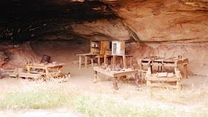
 Cave Spring Trail
Length (round-trip): .6 mi/1 km
Start: Cave Spring parking area
Time: 45 minutes
Trail features a historic cowboy line camp and prehistoric pictographs. Two wooden ladders must be climbed.

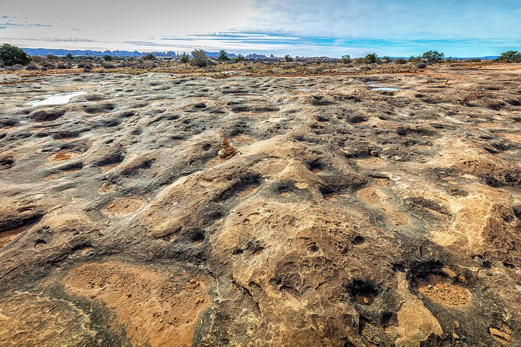
The view along Pothole Point Trail in the Needles District, Canyonlands National Park / Rebecca Latson
Pothole Point Trail
Length (round-trip): .6 mi/1 km
Start: Pothole Point parking area
Time: 40 minutes
Uneven slickrock surface. Trail leads to pothole communities and views of the Needles.
Roadside Ruin Trail
Length (round-trip): .3 mi/.5 km
Start: Roadside Ruin parking area
Time: 20 minutes
Trail features an ancestral Puebloan granary.
Slickrock Trail
Length (round-trip): 2.4 mi/4 km
Start: Near Big Spring Overlook
Time: 2 hours
Uneven slickrock surface. Several viewpoints and sometimes bighorn sheep.
Longer Hikes in the Needles
Chesler Park Loop / Joint Trail
Length: 11 mi/18 km round-trip
Start: Elephant Hill Trailhead
Hiking three miles along this trail brings visitors to a saddle overlooking Chesler Park, a scenic expanse of desert grasses and shrubs surrounded by colorful sandstone spires. The loop around Chesler is fairly level and winds through a series of deep, narrow fractures called the Joint Trail. Five backpacking sites. No water.
Elephant Canyon / Druid Arch
Length: 11 mi/18 km round-trip
Start: Elephant Hill Trailhead
This trail offers one of the most spectacular views in the Needles. It follows the Chesler Park access trail to Elephant Canyon, then travels along the canyon bottom across a mixture of deep sand and loose rock all the way to its upper end. The last .25 mile is a steep climb involving one ladder and some scrambling. Three backpacking sites. Water available seasonally.
Confluence Overlook
Length: 10 mi/16.5 km round-trip
Start: Big Spring Canyon Overlook
Unlike other hikes in the district, this trail traverses mostly dry, open country along the northern edge of the geologic faults that shaped the Needles. Trail ends at a cliff overlooking the junction of the Green and Colorado rivers. At-large camping only. No water.
Big Spring to Squaw Canyon
Length: 7.5 mi/12 km round-trip
Start: Squaw Flat Loop “A” Trailhead
A great introduction to the landscape of the Needles, connecting two canyons for a loop across varied terrain. The route between the canyons climbs steep grades that are dangerous when wet and may make people with a fear of heights uncomfortable. Two backpacking sites in each canyon. Water available seasonally.
Squaw Canyon to Lost Canyon
Length: 8.7 mi/14 km round-trip
Start: Squaw Flat Loop “A” Trailhead
Similar to Big Spring to Squaw Canyon loop, but travels deeper into a canyon with more abundant riparian vegetation, wildlife, and sense of isolation. Three backpacking sites. Water reliably available.
Peekaboo Trail
Length: 10 mi/16.5 km round-trip
Start: Squaw Flat Loop “A” Trailhead
Trail crosses both Squaw and Lost canyons, climbing up and along a series of exposed sandstone rims. Spectacular views are the payoff for this challenging hike. Two ladders must be climbed. One 4WD vehicle accessible campsite at trail's end. Water available seasonally.
Lower Red Lake Canyon
Length: 18.8 mi/30 km round-trip
Start: Elephant Hill Trailhead
The hike from Elephant Hill to the Colorado River is very strenuous, with an elevation change of 1,400 feet (426.7 m). There is little shade along the way as the trail climbs in and out of the Grabens and then descends the steep talus slope of Lower Red Lake Canyon toward the river. This trail is recommended as a multi-day hike. At-large camping only. No water before reaching the river.
Salt Creek Canyon
Length: 22.5 mi/34 km one-way
Start: Peekaboo or Cathedral Butte
The trail follows the main drainage of the canyon past cottonwood groves, through thick brush, and down an old four-wheel-drive road. The trail is often obscured by dense vegetation. Many archaeological sites and arches can be seen. Four designated campsites in upper section. Lower section (along the old road) is at-large camping only. Water is usually available.
Backpacking in the Needles
The Needles is the most popular backpacking destination in the park. Most trailheads are accessible by two-wheel-drive vehicles, and water may be found seasonally in many of the canyons east of Chesler Park.
Permits are required for all overnight trips in the backcountry. During the spring and fall, demand for permits frequently exceeds the number available. If you plan to visit Canyonlands during peak season, especially during spring break (March), it is recommended that you make reservations well in advance.
Designated campsites (one group per site) have been established along most trails. Groups camp at-large in areas without sites or trails. The status of most water sources is available at the visitor center.
Hiking in the Maze District
The Maze is the least accessible district of Canyonlands. Due to the district’s remoteness and the difficulty of roads and trails, travel to the Maze requires more time, as well as a greater degree of self-sufficiency. Rarely do visitors spend less than three days in the Maze, and the area can easily absorb a week-long trip.
The Orange Cliffs Unit of Glen Canyon National Recreation Area shares Canyonlands' western boundary and is administered under the same backcountry management plan and permit/reservation system. While some regulations differ, the information here should assist Orange Cliffs visitors in planning trips.
Location
The Hans Flat Ranger Station, open year-round from 9 a.m. to 4:30 p.m., is two and one-half hours from Green River, Utah. From I-70, take Utah Highway 24 south for 24 miles (38.6 km). A left hand turn just beyond the turnoff to Goblin Valley State Park will take you along a two-wheel-drive dirt road 46 miles (76 km) southeast to the ranger station. There is a small sales area with books and maps. There are no amenities like food or gas, no entrance fees and no potable water sources in the Maze District.
From the ranger station, the canyons of the Maze are another 3 to 6 hours by high-clearance, 4WD (more if traveling by foot). Another four-wheel-drive road leads into the Maze north from Highway 95 near Hite Marina (driving time is 3+ hours to the park boundary).


