Gazing out across Petrified Forest National Park, it's hard to believe that this view once was thick with vegetation, streams, and animals.

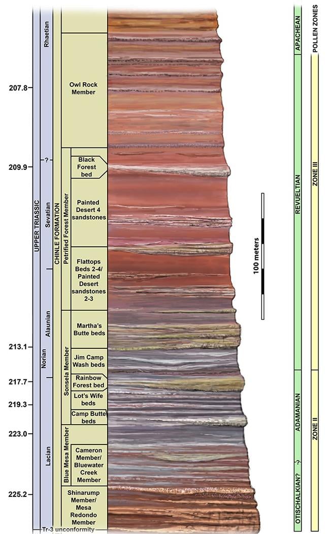
The stratigraphy column of the Chinle Formation, Petrified Forest National Park / NPS graphic
But that was hundreds of millions of years ago, during the Late Triassic Period when the land mass was much, much closer to the equator than it is today. And that landmass, part of the prehistoric continent known as Pangaea, was steamy, lush, and wet.
About that time, Park Service geologists tell us, the region was a vast basin with numerous rivers and streams flowing through the lowland.
A lush landscape with coniferous trees up to nine feet in diameter and towering almost 200 feet (61 m) into the sky rose above the land. Galleries of trees, ferns, and giant horsetails grew abundantly along the waterway, providing food and shelter for many insects, reptiles, amphibians, and other creatures. Cycads, bennettitaleans, ginkgoes, and coniferous trees grew in the slightly dryer areas a short distance from the water.
Over time, trees fell into the waterways, knocked down by wind, undercut by water, or killed by insects. Rivers and streams carried the trees downstream, breaking off branches and roots along the way. Many tree trunks came to rest on the banks of the rivers while others were buried in the stream channels.
Most of the trees decomposed and disappeared, but some of the trees were petrified, becoming the beautiful fossilized logs we see today. Many of the fossilized logs are from a tree called Araucarioxylon arizonicum. Two others, Woodworthia arizonica and Schilderia adamanica, occur in small quantities in the northern part of the park.
At least nine species of fossil trees have been identified from the park; all are now extinct.
Distant volcanoes to the west spewed tons of ash into the atmosphere, carried by the wind into this area where it was incorporated into the river sediments. Some logs were buried by sediment before they could decompose. Ground water dissolved silica from the volcanic ash and carried it into the logs. This solution formed quartz crystals which filled hollows, cracks, even the interior of the cells, and sometimes replaced the cell walls.
The process could be so exact the resulting fossils show many details of the logs’ original surfaces and, occasionally, the internal cell structures. Traces of iron and other minerals combined with quartz during the petrification process, creating the brilliant rainbow of colors. Within the larger cracks and hollows the growth of quartz crystals was not limited in size and larger crystals of clear and milky quartz, purple amethyst, and yellow citrine formed.
This area has endured many changes. As time passed, a thick sequence of younger rock buried the Chinle Formation. Over millions of years, the region was uplifted as part of the massive Colorado Plateau. Wind and water eroded the land, removing the younger layers of rock and exposing parts of the Chinle Formation. Now fossilized logs that were once embedded in the Chinle Formation lie strewn across the clay hills and are exposed in cliff faces.
You might notice that most of the logs are broken into segments. Who cut the logs? This is one of the park’s most common questions!
People did not cut the logs. Because the sections are still in order, we know that the logs fractured after they were buried and the petrification process was complete. Composed of quartz, petrified logs are hard and brittle, breaking easily when subjected to stress. Softer sedimentary layers surround the hard logs. As the sedimentary layers shifted and settled, stress on the rigid logs caused fractures. Some researchers believe that such stress may have been produced by earthquakes or the gradual uplifting of the Colorado Plateau.
Erosion continues today. Rain and wind wear away the land, uncovering additional logs, while freezing and thawing break down the logs exposed on the surface. With the infinite patience of time, the layers of sediment will continue to erode, exposing more pages of this ancient history book.

Who cut the logs? Nobody! Petrified Forest National Park / Rebecca Latson


