You are here

All Photos

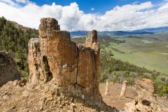
El Capitan at Sunset, Guadalupe Mountains National Park

According to the National Park Service, "Capitan Reef is now recognized as one of the most well-preserved fossil reefs in the world ... Movement of faults over the last 20 million years caused a long-buried portion of the Capitan Reef to rise several thousand feet above its original position. This uplifted block was then exposed to wind and rain causing the softer overlying sediments to erode, uncovering the more resistant fossil reef and forming the modern Guadalupe Mountains.

NPS - D. Buehler
bootstrap

Precariously Perched Desert Bighorn Sheep, Canyonlands National Park

According to the National Park Service, "Desert bighorn sheep roam some of the most inhospitable land in canyon country. Their diet consists of the same spiny shrubs that scrape the shins of hikers. Once feared to be nearing extinction, the desert bighorn is making a tentative comeback in southeast Utah due to reintroduction efforts by the National Park Service. With one of the few remaining native herds, Canyonlands has been a vital source of animals for this program."

NPS - Jennifer Anderson
bootstrap

Early Iron Rung And Stonework Of The Precipice Trail, Acadia National Park

Precipice Loop Trail is definitely not for the faint of heart. With an elevation gain of almost 1,000 feet (305 m) just under a mile (1.4 km), this trail "is a rugged, non-technical climb with open cliff faces and iron rungs. Upon reaching the summit of Champlain Mountain, climbers are rewarded with impressive views." Precipice Loop Trail, however, "is not recommended for small children, for people with a fear of heights, or for anyone in wet weather. Descending the Precipice is dangerous and not advised."

NPS - Michael Custodio
bootstrap

Sandhill Cranes, Dunes, and Mt. Herard In The Distance, Great Sand Dunes National Park And Preserve

One of 250 bird species found in the park, More than 20,000 sandhill cranes will spend 6 - 7 weeks each year in the San Luis Valley during their annual migration to southern New Mexico. Look for them in early February through late March, then again in late September through late March.

National Park Service
bootstrap

An Aerial View Of The Waterpocket Fold, Capitol Reef National Park

According to the National Park Service, "The Waterpocket Fold defines Capitol Reef National Park. A nearly 100-mile long warp in the Earth's crust, the Waterpocket Fold is a classic monocline, a "step-up" in the rock layers. It formed between 50 and 70 million years ago when a major mountain building event in western North America, the Laramide Orogeny, reactivated an ancient buried fault in this region. Movement along the fault caused the west side to shift upwards relative to the east side. The overlying sedimentary layers were draped above the fault and formed a monocline.

National Park Service
bootstrap

Johns Hopkins Inlet On A Sunny Day, Glacier Bay National Park And Preserve

Johns Hopkins Glacier is found at the end of Johns Hopkins Inlet, in the farthest northwest of the Glacier Bay fjord. The glacier fills the end of the fjord, stretching about 1-mile (1.6 km) wide, and reaching 250 feet (76 m) high above the waterline. The ice front extends under sea level, to a depth of approximately 200 feet (61 m), where an underwater moraine protects the deepest extent of the glacial ice like armor against the warm ocean water.

NPS - S. Tevebaugh
bootstrap

INN Member

The easiest way to explore RV-friendly National Park campgrounds.

The Essential RVing Guide to the National Parks

Here’s the definitive guide to National Park System campgrounds where RVers can park their rigs.

Our app is packed with RVing- specific details on more than 250 campgrounds in more than 70 national parks.

You’ll also find stories about RVing in the parks, tips helpful if you’ve just recently become an RVer, and useful planning suggestions.

The Essential RVing Guide to the National Parks

FREE for iPhones and Android phones.