
Ahab had his white whale, Moby-Dick, which drove him to his death. I had the Common Loon, a fish-loving, deep-diving waterfowl that mocked me with its tremolo call as I stood on the shore of Shoshone Lake in Yellowstone National Park.
I had come to Shoshone with my two sons and a long-time friend to enjoy the backcountry via canoe. A pair of loons welcomed us with their calls on our first day not long after we had left the Lewis River Channel that connects Shoshone and Lewis lakes and headed west on Shoshone towards our first night's campsite.
Now, on our last day on the lake, the loons again were hooting and hollaring in their unique speech patterns to warn one and all that humans were around. I had brought a digital recorder with me to record just such an event, set it up on the shore, and turned it on.
The loons, however, weren't cooperating. They settled quietly down and I had collected nearly a half-hour of waves slapping the sandy beach. After turning off the recorder and returning to breakfast, the loons started up again, spooked by more paddlers heading deeper into the Shoshone Lake waterscape. I grabbed the recorder and set it up again on the shore, and envisioned a tremedous recording as the birds again spewed forth their wavering and yodeling. It wasn't until about ten minutes later, after they had settled back down, that I realized a case of "operator failure" had left the recorder in its standby phase.

Crossing Lewis Lake. Bob Mishak photo.
Chagrined and defeated, I turned off the recorder. My boys headed to their tent to pack it and their sleeping bags away, my buddy headed to ours to pack up his things, and I headed to the pit toilet to contemplate.
Naturally, just minutes after settling onto the throne, the loons revved back up, their songs spreading across the lake and shoreline. And the recorder was packed away. Now, mocking loons aren't the only reason to head to Shoshone Lake.
Shoshone Lake Offers More Than Loons
Most Yellowstone visitors don't even think of Shoshone, and fewer still spot it from the overlook on Craig Pass.
But the watery side of the park can be just as impressive as the forests, meadows, and thermal basins. Spanning more than 8,000 acres, and thought to be the largest backcountry lake in the country that you can't drive to, Shoshone offers lakeside campsites, fishing for those with a tolerance for elusive lake trout and brown trout that would offer plank-sized filets, as well as a wonderful geyser basin thought to feature one of the most dense collections of geysers in the world, with more than 80 dotting an area roughly five football fields long by three wide.
Getting there is half the fun. You launch your boat -- canoe or kayak, the choice is yours --- from the dock near the Lewis Campground on the southeast side of Lewis Lake. Things can get a bit hectic here due to the small size of the dock. When we arrived with our two canoes and gear, no one else was there, but before too long two other groups showed up to launch, and we all jockeyed to get our boats into the water and loaded with gear. Green, orange, yellow, and blue dry bags littered the narrow dock, along with coolers, PFDs, throw bags, and fishing poles.
Once you shove off from the dock, you must travel roughly 4 miles northwest towards Shoshone Lake.

The Lewis RIver Channel requires some walking. Kurt Repanshek photo.
On calm days this is no great challenge, but when the winds rise they kick up swells that, while only 2-3 feet high, can make some canoeists a tad nervous. If that's the case, you head directly west across the lake and then paddle north along its shoreline to travel in the lee of the winds.
Once you reach the northern end of Lewis Lake you enter the Lewis River Channel, a narrow, beautiful stream that extends several miles to the outlet of Shoshone Lake, half of which is usually deep enough to paddle. Keen, and fortunate, eyes might spot river otters. Easier seen are lily pads, their yellow flowers bright against the dark green pads, along the shores.
Here and there paddle small convoys of Common Mergansers. At one point I spied one mom and her ducklings lined up on a log running into the stream. Overhead, you might spot a bald eagle, as we did on our trip back out of the channel five days later.
In the final mile or so of the Lewis River Channel, the stream thins out and gets bony with rocks. Here you must pull your boats upstream as you skirt rocks bearing red, blue, and green streaks of plastic left by Royalex boats. My beloved Wenonah Odyssey gained some new scratches in its gel-coat finish, but they were not to be avoided and meant I'd soon be expanding my skills in boat repairs.
Options, Options, Options
Upon reaching Shoshone Lake, your options are many. Most paddlers seem to head west, hoping no doubt to visit the geyser basin during their stay on the lake. You can go east along the lakeshore, but there are few campsites on that side of Shoshone. To the west there are plenty of campsites to choose from -- you typically reserve yours months ahead of your trip, though I've seen some paddlers walk into the park's South Entrance Ranger Station and land sites.
Some sites are better than others, some very much better. Those carrying "mosquito" in their names should be avoided early in summer, for obvious reasons. Others have steep shorelines to negotiate, something that can be tricky when it comes to hauling not just gear but also canoes/kayaks ashore.

One of the nicer campsites on Shoshone. Kurt Repanshek photo.
Unfortunately, more and more sites have been used so many times and beaten down with so many feet and tents that staying in them can be described as camping in dirt and dust. At 8Q4, Moose Creek Point, rangers trying to restore part of the site have posted "Keep Out" signs with hopes natural revegetation will take charge.
I can tell you that there are a few wonderful sites with great landing points, numerous tent sites set amid the lodgepole forest, and offering great views of the lake.
Rocks And Geysers
Walk the shoreline after you've set up camp and, if you like anything about geology or volcanism, you'll be amazed at the diverse color and collection of rocks, stones, and gravels to be seen. There are blackish-gray pumices, ruddy scorias, and speckled andesites, along with a mix of rhyolite, obsidian, and basalt.
Head to the far western shore of the lake and you'll arrive at the Shoshone Geyser Basin, a landscape fuming steam and spewing boiling water from features named Bead, Geyser, Black Boiler Spring, Iron Conch Spring, Kitchen Spring and more. Here, too, is a marshy area rife with waterfowl and the occasional bald eagle looking for a meal.
Fully exploring Shoshone Lake can take time, skills and, at times, patience. Circumnavigating Shoshone Lake can entail long days of paddling as you follow the shoreline.

Though bears aren't seldom seen around Shoshone Lake, you still need to hang your food. Bob Mishak photo.
Cutting across the lake can be done, at the obviously named "Narrows" section. This is typically best done early in the morning or early in the evening once the winds have quit.
As we headed across on our second day, shortly before 10 a.m., the winds weren't too bad, and the swells not yet crowned by white froth. About half-way across the winds did rise, and some whitecaps appeared, but by quartering the waves, and at times taking them head on, we were able to safely cross without any difficulties.
One interesting aspect of the crossing, though, was that the canoe, a 16-and-a-half-foot Ally packable canoe (more on the Ally in a future post), flexed its aluminum chines, thwarts, and gunnels in such a way that the boat actually bent as we crossed waves -- my son, Sean, in the front would be dropping down off the crest while I was still heading up.
To Build A Fire, Or Not
If there's a downside to exploring Yellowstone via Shoshone Lake, it's that the Park Service doesn't allow campfires here. The official line is that "Past use of campfires and woodgathering practices, combined with high levels of visitor use, caused significant and lasting impacts." Yet today the campsites and their surroundings are cluttered with downed trees waiting for the next conflagration to arrive, while campers rely on gas- or charcoal fires to cook their meals.
The banishment of campfires to set around after a long day and chat while the flames leap and flicker places a once-integral part of backcountry camping out of reach. Would a return to campfires on Shoshone's shores denude the forests? The lake does enjoy high use, and no doubt a return to campfires would see a significant amount of that downed and kiln-dry wood go up in smoke.
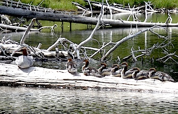
Mergansers are found along the Lewis River Channel. Kurt Repanshek photo.
On the other hand, the forest's fuel load seems incredibly high, something that could lead to a particularly large, and hot, wildfire with a correctly aimed lightning strike.
While a fire would have been nice during our recent five-day stay on Shoshone, sitting under the star-studded night sky was just as enjoyable without a fire, and made it a bit easier to see the stars.
Traveler footnote: Don't have a canoe or kayak? No worries. You can backpack down to the lake from Old Faithful via the Howard Eaton and Shoshone Lake trails, or via the Dogshead Trail near Lewis Lake. Both will lead you to some great lake-side campsites.
If You Go
Lewis Lake to Shoshone Lake
Trailhead: Lewis Lake boat dock.
Distance: Varies, though in our five-day trip we covered about 25 miles.
Difficulty: Moderate to difficult, depending on your paddling skills and the weather.
Maps: Trails Illustrated's No. 302, Southwest Yellowstone - Old Faithful Trail Map


Comments
I thought this was going to be about your inability to *see* the loon. I was going to suggest we really needed to get you better binoculars. Although I did have an episode paddling Long Lake in Acadia when a loon kept surfacing very close to the canoe on the opposite side of where I was looking, then dived as soon as I moved my head.
I see both sides of the fire argument. It's alarming how devoid of any fallen wood the area around some popular campsites can be, to the point of completely altering floor communities of fauna and flora. On the other hand, popular sites tend to be altered already, so you could make a case that it doesn't matter. I'm not sure how effective of a fire retardant having an area X meters in radius from a string of popular campsites completely denuded of wood would be. You can usually find a "too far" line where people don't want to walk any farther for wood. Beyond that, there will be just as much ground fuel. Now, if campers selectively removed fuel over a greater area...
I must admit a measure or two of surprise at the loons, Kirby. I've long associated their calls with evenings and early mornings, and these two called to us around noon on our first day on the lake. We found them in the same area four days later...so they must have carved some sort of territory out of the area. They were visible all day long, and not bashful at all, either in calling or popping up relatively near to us. No binoculars needed! (But a longer camera lens would have been nice....;-))