
This map, said to have come from Blackberry Farm Resort, shows two trails -- the Boundary Trail and the Blair Gap Trail -- that are not listed on Great Smoky Mountains National Park's official trail map/Southern Forest Watch
Sometime in recent years two trails running more than a mile-and-a-half were cut into the backcountry of Great Smoky Mountains National Park, allegedly for the use of a private resort that borders the park, according to court documents.
When contacted by the Traveler, park officials declined to discuss the trails, or even acknowledge their existence, as their presence has been raised in litigation. However, the "Boundary Trail" and "Blair Gap Trail" depicted on a trail map purportedly handed out by the Blackberry Farm Resort do not match any trails on the park's official trail map. Together they run along the park's western boundary roughly from the Beard Cane Trail to the Cane Creek Trail. Officials at the resort, where rooms start at $745 a night, had no immediate comment when asked about the trails this week.

A trail of downed trees allegedly marked an illegal trail cut in Great Smoky Mountains National Park/Southern Forest Watch
The existence of the trails surfaced in connection with a lawsuit brought against the Park Service by Southern Forest Watch, a nonprofit group organized to overturn the park's $4 per night fee charged on backcountry travelers. Though not central to the fight over the backcountry reservation system, the group pointed to the "illegal trail system" as part of a pattern of "political patronage" that former park Superintendent Dale Ditmanson oversaw. Mr. Ditmanson, who instituted the backcountry fee system in 2013, retired from the Park Service earlier this year.
By allowing the Blackberry Farm Resort to maintain these trails for the use of their customers and residents, Great Smoky Mountains officials were limiting the general public's access to the park's backcountry and allowing it to be impaired, charges Southern Forest Watch's lawsuit.
The Park Service, in court documents responding to Southern Forest Watch's complaint, denied allowing a "private resort to maintain and utilize their own separate, exclusive network of trails into, on and within the boundaries" of the park. However the agency did admit that there was a signpost with a map box located outside the park boundary and that "any signs that were erected within Park boundaries by Blackberry Farm Resort were erected without permission from NPS and have since been removed."
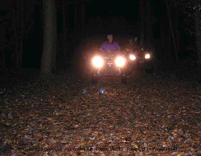
These ATVers allegedly were entering Great Smoky Mountains National Park from the Cane Creek Trailhead/Southern Forest Watch
The trail map showing the Boundary and Blair Gap trails came from the map box on the signpost, according to Southern Forest Watch's lawyer.
The trail signs and maps were found by John Quillen, a member of Southern Forest Watch. A park volunteer who regularly hikes the Cane Creek Trail to help maintain it, Mr. Quillen discovered the Boundary Trail in 2009 when he came upon a trail of trees that had been chainsawed down. He and some friends also heard a chainsaw at work, and encountered riders on two all-terrain vehicles who allegedly claimed they had come from Blackberry Farm. Photos of a trail sign, the ATV, and downed trees are part of Southern Forest Watch's court filing.
No court date for the matter has been set.


Comments
Here is a picture of a sign that currently sits at the intersection of Ace Gap and Beard Cane trails, where the private resort trail system begins. Does this look like an NPS sign?
http://www.southernhighlanders.com/9_BlairGapTrailSignlittleun.JPG
Well that is certainly interesting. Just to confirm, that sign and the "trail" cover-up attempt are inside the park??? The hand-painted sign and the alleged use of chainsaws to cover up the "trail" seem so far-fetched as to make it unbelievable!
This is for the "trail denier" crowd that seems to creep from the NPS woodwork around here. This document was filed in federal court last week, I have excerpted it here.
AFFIDAVIT OF MARK COOKE
I, Mark Cooke, declare that:
1. I recently hike along Ace Gap Trail to the trails intersection with Beard Cane Trail.
2. While hiking along Ace Gap Trail, I noticed what appeared to be a recently installed survey pin on the south side of the trail. The coordinates of that survey pin are N35 40.264, W83 49.850.
3. This recently installed survey pin appeared to be on the National Park Service side of the trail within the boundary of the Great Smoky Mountains National Park.
4. Pictures of this survey pin are attached hereto as Exhibits A and B.
5. In this same area, I noticed 2 small National Park Service boundary signs tacked about 20 feet apart onto small 4 inch diameter trees. The park boundary sign installation did not appear to be the work of the National Park Service.
6. Attached as Exhibit C is a topographical map showing this portion of my hike up Ace Gap Trail.
7. At the intersection of Ace Gap Trail and Beard Cane Trail, there is erected a non-National Park Service sign that states: “Blair Gap Trail Closed Beyond This Point.” Pictures of the sign are attached hereto as Exhibits D, E and F.
8. Adjacent to the new trail sign, there is survey tape and the corner of an National Park Service boundary sign on a tree stump. Pictures showing the stump and removed National Park Service boundary sign are attached hereto as Exhibits G and H.
Pursuant to 28 U.S.C. § 1746, I declare, under penalty of perjury, that the foregoing is true and correct.
Dated July 17, 2014. /s/ Mark Cooke
John, you do realize those coordinates you posted are on private property outside of the park by about a 1/10th of a mile, right? Your friend was basically hiking on a road on private property.
Let's see, we have the NPS admitting that Blackberry Farms had trail signs erected on NPS property and asked them to remove it, there are pics of the trails on NPS land with the chain sawed trees and Blackberry Farms who " refuses to comment" and today a signed affidavit from another witness and then we have Gary Wilson citing gps coordinates from someone he doesn't know of a place he has admittedly never been. I can't imagine why no one would ever believe a guy who posts fraudulently under my name on this site. Of course, this is coming from a guy who last week said that he thinks the Smokies should be free of fees except for backcountry campers, so he can not only get paid to do commercial photography in the Smokies but not have to be bothered with the burden of paying to do so. You just can't make stuff like this up. I'm still waiting for your much ballyhooed expedition up to the trails, Gary. I presume you know how to work a camera and could provide some personal evidence. You are up there "all the time". Or is it because no one is paying you to go up there. Those of us dumb, native Tennesseans who don't make our living off the Smokies are on pins and needles.
John, the coordinates posted shows that he's on private property as linked to in my post. This is a non-issue. I also never stated that i'm for or against the fees, and you are quoting me very much out of context again. I said it would have pluses and minuses. The rest of your accusations about me is just more jargon that doesn't deserve any response.
New information uncovered by local news agency proving that the NPS was aware of the Blackberry Farm Trail system for many years. A document obtained through FOIA from ABC affiliate WATE shows that the private resort was warned about the trail and told to stop but did not and NPS did nothing.
http://www.wate.com/story/26631327/watchdog-group-alleges-blackberry-far...
The letter would seem to indicate that both of the major antagonist in this thread have been incorrect with their primary points. Obviously it does show (contrary to Gary's assertions) that Blackberry made notorious and illegal use of trails in the Park. On the otherhand, the letter indicates that this was not a condoned practice by the upper management of the Park. It well documents they made repeated efforts to stop the illegal use once becoming aware of the issue.
To me, most glaring shortfall of the NPS was by the ranger that inspected the area in 2009. How does one find violations, ask for corrections and then not revisit the area for 3 years and even then only because his superiors asked him to do so. No doubt this ranger fell short of his duty. Malfeasance or misfeasance? Perhaps that is what needs to be investigated.