This map, said to have come from Blackberry Farm Resort, shows two trails -- the Boundary Trail and the Blair Gap Trail -- that are not listed on Great Smoky Mountains National Park's official trail map/Southern Forest Watch
Sometime in recent years two trails running more than a mile-and-a-half were cut into the backcountry of Great Smoky Mountains National Park, allegedly for the use of a private resort that borders the park, according to court documents.
When contacted by the Traveler, park officials declined to discuss the trails, or even acknowledge their existence, as their presence has been raised in litigation. However, the "Boundary Trail" and "Blair Gap Trail" depicted on a trail map purportedly handed out by the Blackberry Farm Resort do not match any trails on the park's official trail map. Together they run along the park's western boundary roughly from the Beard Cane Trail to the Cane Creek Trail. Officials at the resort, where rooms start at $745 a night, had no immediate comment when asked about the trails this week.

A trail of downed trees allegedly marked an illegal trail cut in Great Smoky Mountains National Park/Southern Forest Watch
The existence of the trails surfaced in connection with a lawsuit brought against the Park Service by Southern Forest Watch, a nonprofit group organized to overturn the park's $4 per night fee charged on backcountry travelers. Though not central to the fight over the backcountry reservation system, the group pointed to the "illegal trail system" as part of a pattern of "political patronage" that former park Superintendent Dale Ditmanson oversaw. Mr. Ditmanson, who instituted the backcountry fee system in 2013, retired from the Park Service earlier this year.
By allowing the Blackberry Farm Resort to maintain these trails for the use of their customers and residents, Great Smoky Mountains officials were limiting the general public's access to the park's backcountry and allowing it to be impaired, charges Southern Forest Watch's lawsuit.
The Park Service, in court documents responding to Southern Forest Watch's complaint, denied allowing a "private resort to maintain and utilize their own separate, exclusive network of trails into, on and within the boundaries" of the park. However the agency did admit that there was a signpost with a map box located outside the park boundary and that "any signs that were erected within Park boundaries by Blackberry Farm Resort were erected without permission from NPS and have since been removed."

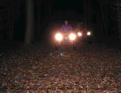
These ATVers allegedly were entering Great Smoky Mountains National Park from the Cane Creek Trailhead/Southern Forest Watch
The trail map showing the Boundary and Blair Gap trails came from the map box on the signpost, according to Southern Forest Watch's lawyer.
The trail signs and maps were found by John Quillen, a member of Southern Forest Watch. A park volunteer who regularly hikes the Cane Creek Trail to help maintain it, Mr. Quillen discovered the Boundary Trail in 2009 when he came upon a trail of trees that had been chainsawed down. He and some friends also heard a chainsaw at work, and encountered riders on two all-terrain vehicles who allegedly claimed they had come from Blackberry Farm. Photos of a trail sign, the ATV, and downed trees are part of Southern Forest Watch's court filing.
No court date for the matter has been set.

 Support Essential Coverage of Essential Places


Comments
Nope, SB, I don't have to present any evidence of anything because I'm not the opposing side of your argument. I'm sitting on the sidelines trying to understand, and with the angry vehemence fueling your side, it's hard to get objective information, which is what my requests for clarification have been seeking. I gotta tell you, though, good luck convincing an objective judge when your diatribe has been such that it moved Ecbuck and I to a similar viewpoint.
That's why we take our argument to offical judges.
Somewhat familiar with Common Law and VERY familiar with real estate law. At best, the NPS would have a claim of prescriptive easement which would allow it to use the trail but would not give it ownership. It doesn't appear they excercised that right. The NPS has never owned the property and you can't give away property you don't own.
If anyone would have a right of inverse condemnation, it would be Sundquist (or the prior property owner). But then the NPS would have had to excercise eminent domain and I have seen no evdience the NPS went through eminent domain procedures which require a court hearing and payment to the property owner.
If any of you are interested as to why this private resort has been allowed to rape the Smokies for financial gain while the nps turns a blind eye, here is your political answer.
http://www.democraticunderground.com/discuss/duboard.php?az=view_all&add...